Maxim Khomiakov
GeoFormer: A Multi-Polygon Segmentation Transformer
Nov 25, 2024


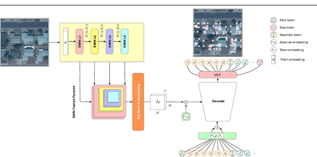
Abstract:In remote sensing there exists a common need for learning scale invariant shapes of objects like buildings. Prior works relies on tweaking multiple loss functions to convert segmentation maps into the final scale invariant representation, necessitating arduous design and optimization. For this purpose we introduce the GeoFormer, a novel architecture which presents a remedy to the said challenges, learning to generate multipolygons end-to-end. By modeling keypoints as spatially dependent tokens in an auto-regressive manner, the GeoFormer outperforms existing works in delineating building objects from satellite imagery. We evaluate the robustness of the GeoFormer against former methods through a variety of parameter ablations and highlight the advantages of optimizing a single likelihood function. Our study presents the first successful application of auto-regressive transformer models for multi-polygon predictions in remote sensing, suggesting a promising methodological alternative for building vectorization.
Polygonizer: An auto-regressive building delineator
Apr 08, 2023


Abstract:In geospatial planning, it is often essential to represent objects in a vectorized format, as this format easily translates to downstream tasks such as web development, graphics, or design. While these problems are frequently addressed using semantic segmentation, which requires additional post-processing to vectorize objects in a non-trivial way, we present an Image-to-Sequence model that allows for direct shape inference and is ready for vector-based workflows out of the box. We demonstrate the model's performance in various ways, including perturbations to the image input that correspond to variations or artifacts commonly encountered in remote sensing applications. Our model outperforms prior works when using ground truth bounding boxes (one object per image), achieving the lowest maximum tangent angle error.
Learning to Generate 3D Representations of Building Roofs Using Single-View Aerial Imagery
Mar 20, 2023


Abstract:We present a novel pipeline for learning the conditional distribution of a building roof mesh given pixels from an aerial image, under the assumption that roof geometry follows a set of regular patterns. Unlike alternative methods that require multiple images of the same object, our approach enables estimating 3D roof meshes using only a single image for predictions. The approach employs the PolyGen, a deep generative transformer architecture for 3D meshes. We apply this model in a new domain and investigate the sensitivity of the image resolution. We propose a novel metric to evaluate the performance of the inferred meshes, and our results show that the model is robust even at lower resolutions, while qualitatively producing realistic representations for out-of-distribution samples.
SolarDK: A high-resolution urban solar panel image classification and localization dataset
Dec 02, 2022


Abstract:The body of research on classification of solar panel arrays from aerial imagery is increasing, yet there are still not many public benchmark datasets. This paper introduces two novel benchmark datasets for classifying and localizing solar panel arrays in Denmark: A human annotated dataset for classification and segmentation, as well as a classification dataset acquired using self-reported data from the Danish national building registry. We explore the performance of prior works on the new benchmark dataset, and present results after fine-tuning models using a similar approach as recent works. Furthermore, we train models of newer architectures and provide benchmark baselines to our datasets in several scenarios. We believe the release of these datasets may improve future research in both local and global geospatial domains for identifying and mapping of solar panel arrays from aerial imagery. The data is accessible at https://osf.io/aj539/.
 Add to Chrome
 Add to Firefox
 Add to Edge