GeoFormer: A Multi-Polygon Segmentation Transformer
Paper and Code
Nov 25, 2024


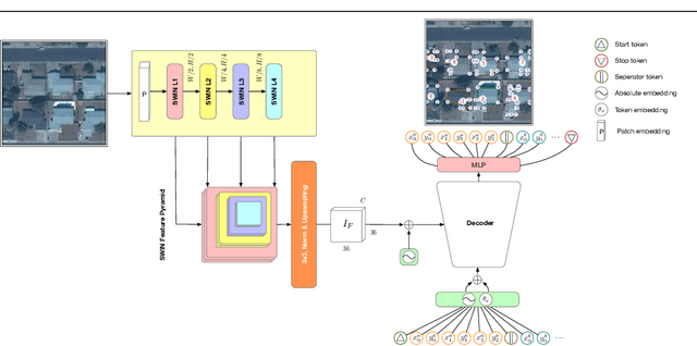
In remote sensing there exists a common need for learning scale invariant shapes of objects like buildings. Prior works relies on tweaking multiple loss functions to convert segmentation maps into the final scale invariant representation, necessitating arduous design and optimization. For this purpose we introduce the GeoFormer, a novel architecture which presents a remedy to the said challenges, learning to generate multipolygons end-to-end. By modeling keypoints as spatially dependent tokens in an auto-regressive manner, the GeoFormer outperforms existing works in delineating building objects from satellite imagery. We evaluate the robustness of the GeoFormer against former methods through a variety of parameter ablations and highlight the advantages of optimizing a single likelihood function. Our study presents the first successful application of auto-regressive transformer models for multi-polygon predictions in remote sensing, suggesting a promising methodological alternative for building vectorization.
 Add to Chrome
 Add to Firefox
 Add to Edge