Marek Vajgl
Coastline extraction from ALOS-2 satellite SAR images
Apr 10, 2021


Abstract:The continuous monitoring of a shore plays an essential role in designing strategies for shore protection against erosion. To avoid the effect of clouds and sunlight, satellite-based imagery with synthetic aperture radar is used to provide the required data. We show how such data can be processed using state-of-the-art methods, namely, by a deep-learning-based approach, to detect the coastline location. We split the process into data reading, data preprocessing, model training, inference, ensembling, and postprocessing, and describe the best techniques for each of the parts. Finally, we present our own solution that is able to precisely extract the coastline from an image even if it is not recognizable by a human. Our solution has been validated against the real GPS location of the coastline during Signate's competition, where it was runner-up among 109 teams across the whole world.
Poly-YOLO: higher speed, more precise detection and instance segmentation for YOLOv3
May 29, 2020


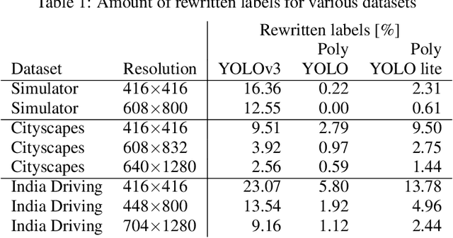
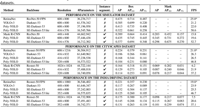
Abstract:We present a new version of YOLO with better performance and extended with instance segmentation called Poly-YOLO. Poly-YOLO builds on the original ideas of YOLOv3 and removes two of its weaknesses: a large amount of rewritten labels and inefficient distribution of anchors. Poly-YOLO reduces the issues by aggregating features from a light SE-Darknet-53 backbone with a hypercolumn technique, using stairstep upsampling, and produces a single scale output with high resolution. In comparison with YOLOv3, Poly-YOLO has only 60% of its trainable parameters but improves mAP by a relative 40%. We also present Poly-YOLO lite with fewer parameters and a lower output resolution. It has the same precision as YOLOv3, but it is three times smaller and twice as fast, thus suitable for embedded devices. Finally, Poly-YOLO performs instance segmentation using bounding polygons. The network is trained to detect size-independent polygons defined on a polar grid. Vertices of each polygon are being predicted with their confidence, and therefore Poly-YOLO produces polygons with a varying number of vertices.
 Add to Chrome
 Add to Firefox
 Add to Edge