Ivan Zvonkov
How accurate are existing land cover maps for agriculture in Sub-Saharan Africa?
Jul 05, 2023Abstract:Satellite Earth observations (EO) can provide affordable and timely information for assessing crop conditions and food production. Such monitoring systems are essential in Africa, where there is high food insecurity and sparse agricultural statistics. EO-based monitoring systems require accurate cropland maps to provide information about croplands, but there is a lack of data to determine which of the many available land cover maps most accurately identify cropland in African countries. This study provides a quantitative evaluation and intercomparison of 11 publicly available land cover maps to assess their suitability for cropland classification and EO-based agriculture monitoring in Africa using statistically rigorous reference datasets from 8 countries. We hope the results of this study will help users determine the most suitable map for their needs and encourage future work to focus on resolving inconsistencies between maps and improving accuracy in low-accuracy regions.
Lightweight, Pre-trained Transformers for Remote Sensing Timeseries
Apr 27, 2023


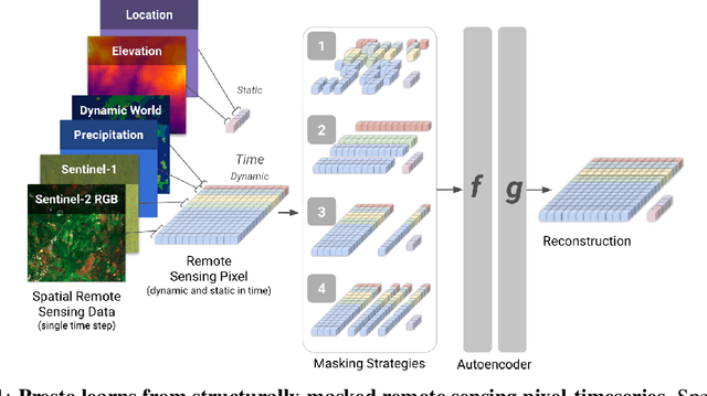
Abstract:Machine learning algorithms for parsing remote sensing data have a wide range of societally relevant applications, but labels used to train these algorithms can be difficult or impossible to acquire. This challenge has spurred research into self-supervised learning for remote sensing data aiming to unlock the use of machine learning in geographies or application domains where labelled datasets are small. Current self-supervised learning approaches for remote sensing data draw significant inspiration from techniques applied to natural images. However, remote sensing data has important differences from natural images -- for example, the temporal dimension is critical for many tasks and data is collected from many complementary sensors. We show that designing models and self-supervised training techniques specifically for remote sensing data results in both smaller and more performant models. We introduce the Pretrained Remote Sensing Transformer (Presto), a transformer-based model pre-trained on remote sensing pixel-timeseries data. Presto excels at a wide variety of globally distributed remote sensing tasks and outperforms much larger models. Presto can be used for transfer learning or as a feature extractor for simple models, enabling efficient deployment at scale.
 Add to Chrome
 Add to Firefox
 Add to Edge