Gabriel Kasmi
One Wave to Explain Them All: A Unifying Perspective on Post-hoc Explainability
Oct 02, 2024Abstract:Despite the growing use of deep neural networks in safety-critical decision-making, their inherent black-box nature hinders transparency and interpretability. Explainable AI (XAI) methods have thus emerged to understand a model's internal workings, and notably attribution methods also called saliency maps. Conventional attribution methods typically identify the locations -- the where -- of significant regions within an input. However, because they overlook the inherent structure of the input data, these methods often fail to interpret what these regions represent in terms of structural components (e.g., textures in images or transients in sounds). Furthermore, existing methods are usually tailored to a single data modality, limiting their generalizability. In this paper, we propose leveraging the wavelet domain as a robust mathematical foundation for attribution. Our approach, the Wavelet Attribution Method (WAM) extends the existing gradient-based feature attributions into the wavelet domain, providing a unified framework for explaining classifiers across images, audio, and 3D shapes. Empirical evaluations demonstrate that WAM matches or surpasses state-of-the-art methods across faithfulness metrics and models in image, audio, and 3D explainability. Finally, we show how our method explains not only the where -- the important parts of the input -- but also the what -- the relevant patterns in terms of structural components.
Can We Reliably Improve the Robustness to Image Acquisition of Remote Sensing of PV Systems?
Sep 21, 2023
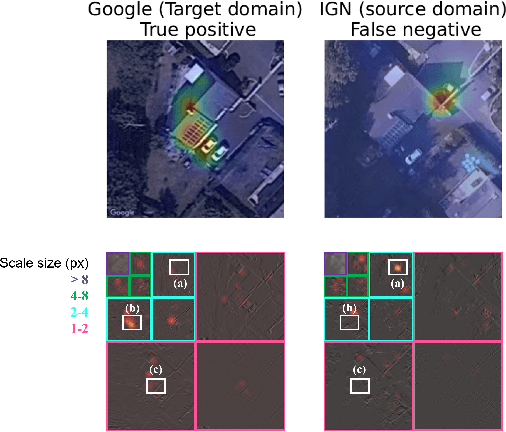

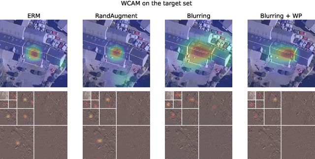
Abstract:Photovoltaic (PV) energy is crucial for the decarbonization of energy systems. Due to the lack of centralized data, remote sensing of rooftop PV installations is the best option to monitor the evolution of the rooftop PV installed fleet at a regional scale. However, current techniques lack reliability and are notably sensitive to shifts in the acquisition conditions. To overcome this, we leverage the wavelet scale attribution method (WCAM), which decomposes a model's prediction in the space-scale domain. The WCAM enables us to assess on which scales the representation of a PV model rests and provides insights to derive methods that improve the robustness to acquisition conditions, thus increasing trust in deep learning systems to encourage their use for the safe integration of clean energy in electric systems.
PyPVRoof: a Python package for extracting the characteristics of rooftop PV installations using remote sensing data
Sep 05, 2023

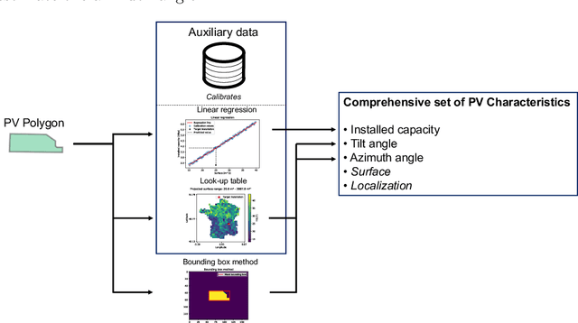

Abstract:Photovoltaic (PV) energy grows at an unprecedented pace, which makes it difficult to maintain up-to-date and accurate PV registries, which are critical for many applications such as PV power generation estimation. This lack of qualitative data is especially true in the case of rooftop PV installations. As a result, extensive efforts are put into the constitution of PV inventories. However, although valuable, these registries cannot be directly used for monitoring the deployment of PV or estimating the PV power generation, as these tasks usually require PV systems {\it characteristics}. To seamlessly extract these characteristics from the global inventories, we introduce {\tt PyPVRoof}. {\tt PyPVRoof} is a Python package to extract essential PV installation characteristics. These characteristics are tilt angle, azimuth, surface, localization, and installed capacity. {\tt PyPVRoof} is designed to cover all use cases regarding data availability and user needs and is based on a benchmark of the best existing methods. Data for replicating our accuracy benchmarks are available on our Zenodo repository \cite{tremenbert2023pypvroof}, and the package code is accessible at this URL: \url{https://github.com/gabrielkasmi/pypvroof}.
Scale Matters: Attribution Meets the Wavelet Domain to Explain Model Sensitivity to Image Corruptions
May 24, 2023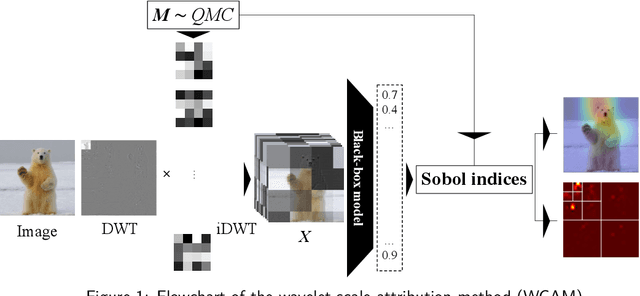
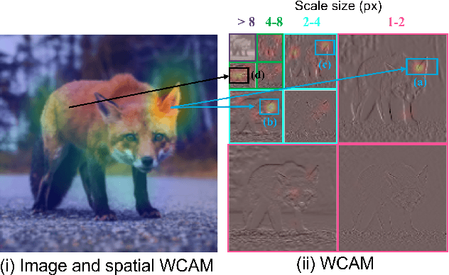
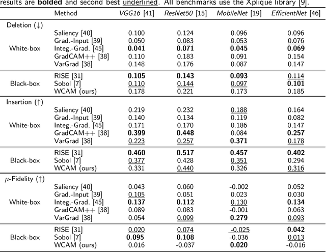
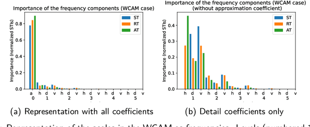
Abstract:Neural networks have shown remarkable performance in computer vision, but their deployment in real-world scenarios is challenging due to their sensitivity to image corruptions. Existing attribution methods are uninformative for explaining the sensitivity to image corruptions, while the literature on robustness only provides model-based explanations. However, the ability to scrutinize models' behavior under image corruptions is crucial to increase the user's trust. Towards this end, we introduce the Wavelet sCale Attribution Method (WCAM), a generalization of attribution from the pixel domain to the space-scale domain. Attribution in the space-scale domain reveals where and on what scales the model focuses. We show that the WCAM explains models' failures under image corruptions, identifies sufficient information for prediction, and explains how zoom-in increases accuracy.
A crowdsourced dataset of aerial images with annotated solar photovoltaic arrays and installation metadata
Sep 08, 2022


Abstract:Photovoltaic (PV) energy generation plays a crucial role in the energy transition. Small-scale PV installations are deployed at an unprecedented pace, and their integration into the grid can be challenging since public authorities often lack quality data about them. Overhead imagery is increasingly used to improve the knowledge of residential PV installations with machine learning models capable of automatically mapping these installations. However, these models cannot be easily transferred from one region or data source to another due to differences in image acquisition. To address this issue known as domain shift and foster the development of PV array mapping pipelines, we propose a dataset containing aerial images, annotations, and segmentation masks. We provide installation metadata for more than 28,000 installations. We provide ground truth segmentation masks for 13,000 installations, including 7,000 with annotations for two different image providers. Finally, we provide installation metadata that matches the annotation for more than 8,000 installations. Dataset applications include end-to-end PV registry construction, robust PV installations mapping, and analysis of crowdsourced datasets.
DeepSolar tracker: towards unsupervised assessment with open-source data of the accuracy of deep learning-based distributed PV mapping
Jul 15, 2022
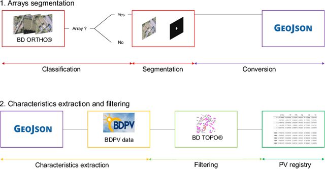
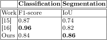

Abstract:Photovoltaic (PV) energy is key to mitigating the current energy crisis. However, distributed PV generation, which amounts to half of the PV energy generation, makes it increasingly difficult for transmission system operators (TSOs) to balance the load and supply and avoid grid congestions. Indeed, in the absence of measurements, estimating the distributed PV generation is tough. In recent years, many remote sensing-based approaches have been proposed to map distributed PV installations. However, to be applicable in industrial settings, one needs to assess the accuracy of the mapping over the whole deployment area. We build on existing work to propose an automated PV registry pipeline. This pipeline automatically generates a dataset recording all distributed PV installations' location, area, installed capacity, and tilt angle. It only requires aerial orthoimagery and topological data, both of which are freely accessible online. In order to assess the accuracy of the registry, we propose an unsupervised method based on the {\it Registre national d'installation} (RNI), that centralizes all individual PV systems aggregated at communal level, enabling practitioners to assess the accuracy of the registry and eventually remove outliers. We deploy our model on 9 French {\it d\'epartements} covering more than 50 000 square kilometers, providing the largest mapping of distributed PV panels with this level of detail to date. We then demonstrate how practitioners can use our unsupervised accuracy assessment method to assess the accuracy of the outputs. In particular, we show how it can easily identify outliers in the detections. Overall, our approach paves the way for a safer integration of deep learning-based pipelines for remote PV mapping. Code is available at {\tt https://github.com/gabrielkasmi/dsfrance}.
 Add to Chrome
 Add to Firefox
 Add to Edge