 Add to Chrome
 Add to Firefox
 Add to Edge
ClustViT: Clustering-based Token Merging for Semantic Segmentation
Oct 02, 2025Vision Transformers can achieve high accuracy and strong generalization across various contexts, but their practical applicability on real-world robotic systems is limited due to their quadratic attention complexity. Recent works have focused on dynamically merging tokens according to the image complexity. Token merging works well for classification but is less suited to dense prediction. We propose ClustViT, where we expand upon the Vision Transformer (ViT) backbone and address semantic segmentation. Within our architecture, a trainable Cluster module merges similar tokens along the network guided by pseudo-clusters from segmentation masks. Subsequently, a Regenerator module restores fine details for downstream heads. Our approach achieves up to 2.18x fewer GFLOPs and 1.64x faster inference on three different datasets, with comparable segmentation accuracy. Our code and models will be made publicly available.
A Survey on Dynamic Neural Networks: from Computer Vision to Multi-modal Sensor Fusion
Jan 13, 2025Model compression is essential in the deployment of large Computer Vision models on embedded devices. However, static optimization techniques (e.g. pruning, quantization, etc.) neglect the fact that different inputs have different complexities, thus requiring different amount of computations. Dynamic Neural Networks allow to condition the number of computations to the specific input. The current literature on the topic is very extensive and fragmented. We present a comprehensive survey that synthesizes and unifies existing Dynamic Neural Networks research in the context of Computer Vision. Additionally, we provide a logical taxonomy based on which component of the network is adaptive: the output, the computation graph or the input. Furthermore, we argue that Dynamic Neural Networks are particularly beneficial in the context of Sensor Fusion for better adaptivity, noise reduction and information prioritization. We present preliminary works in this direction.
Landslide mapping from Sentinel-2 imagery through change detection
May 30, 2024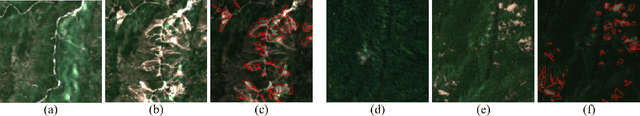
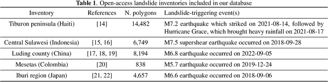
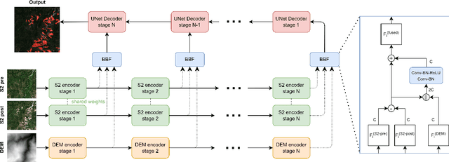
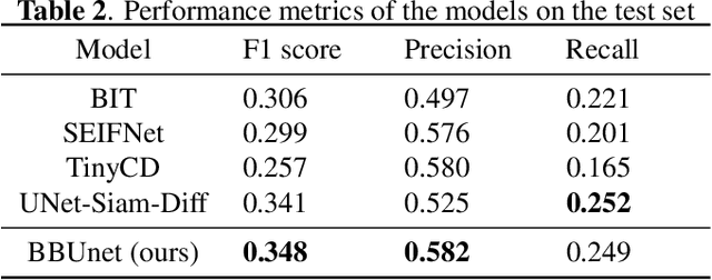
Landslides are one of the most critical and destructive geohazards. Widespread development of human activities and settlements combined with the effects of climate change on weather are resulting in a high increase in the frequency and destructive power of landslides, making them a major threat to human life and the economy. In this paper, we explore methodologies to map newly-occurred landslides using Sentinel-2 imagery automatically. All approaches presented are framed as a bi-temporal change detection problem, requiring only a pair of Sentinel-2 images, taken respectively before and after a landslide-triggering event. Furthermore, we introduce a novel deep learning architecture for fusing Sentinel-2 bi-temporal image pairs with Digital Elevation Model (DEM) data, showcasing its promising performances w.r.t. other change detection models in the literature. As a parallel task, we address limitations in existing datasets by creating a novel geodatabase, which includes manually validated open-access landslide inventories over heterogeneous ecoregions of the world. We release both code and dataset with an open-source license.