Deqiang Xu
3DRIMR: 3D Reconstruction and Imaging via mmWave Radar based on Deep Learning
Aug 05, 2021


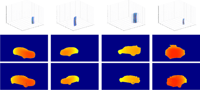
Abstract:mmWave radar has been shown as an effective sensing technique in low visibility, smoke, dusty, and dense fog environment. However tapping the potential of radar sensing to reconstruct 3D object shapes remains a great challenge, due to the characteristics of radar data such as sparsity, low resolution, specularity, high noise, and multi-path induced shadow reflections and artifacts. In this paper we propose 3D Reconstruction and Imaging via mmWave Radar (3DRIMR), a deep learning based architecture that reconstructs 3D shape of an object in dense detailed point cloud format, based on sparse raw mmWave radar intensity data. The architecture consists of two back-to-back conditional GAN deep neural networks: the first generator network generates 2D depth images based on raw radar intensity data, and the second generator network outputs 3D point clouds based on the results of the first generator. The architecture exploits both convolutional neural network's convolutional operation (that extracts local structure neighborhood information) and the efficiency and detailed geometry capture capability of point clouds (other than costly voxelization of 3D space or distance fields). Our experiments have demonstrated 3DRIMR's effectiveness in reconstructing 3D objects, and its performance improvement over standard techniques.
LIDAUS: Localization of IoT Device via Anchor UAV SLAM
Aug 05, 2021


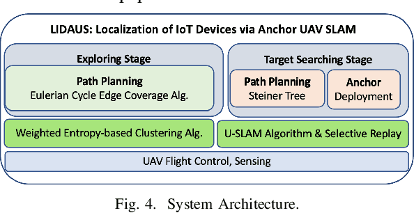
Abstract:We introduce LIDAUS Localization of IoT Device via Anchor UAV SLAM), an infrastructure-free, multi-stage SLAM system that utilizes an Unmanned Aerial Vehicle (UAV) to accurately localize IoT devices in a 3D indoor space where GPS signals are unavailable or weak, e.g., manufacturing factories, disaster sites, or smart buildings. The lack of GPS signals and infrastructure support makes most of the existing indoor localization systems not practical when localizing a large number of wireless IoT devices. In addition, safety concerns, access restriction, and simply the huge amount of IoT devices make it not practical for humans to manually localize and track IoT devices. To address these challenges, the UAV in our LIDAUS system conducts multi-stage 3D SLAM trips to localize devices based only on RSSIs, the most widely available measurement of the signals of almost all commodity IoT devices. The main novelties of the system include a weighted entropy-based clustering algorithm to select high quality RSSI observation locations, a 3D U-SLAM algorithm that is enhanced by deploying anchor beacons along the UAV's path, and the path planning based on Eulerian cycles on multi-layer grid graphs that model the space in exploring stage and Steiner tree paths in searching stages. Our simulations and experiments of Bluetooth IoT devices have demonstrated that the system can achieve high localization accuracy based only on RSSIs of commodity IoT devices.
 Add to Chrome
 Add to Firefox
 Add to Edge