Chang-Sik Choi
Leveraging Aerial Platforms for Downlink Communications in Sparse Satellite Networks
Nov 28, 2024Abstract:Although a significant number satellites are deemed essential for facilitating diverse applications of satellite networks, aerial platforms are emerging as excellent alternatives for enabling reliable communications with fewer satellites. In scenarios with sparse satellite networks, aerial platforms participate in downlink communications, serving effectively as relays and providing comparable or even superior coverage compared to a large number of satellites. This paper explores the role of aerial platforms in assisting downlink communications, emphasizing their potential as an alternative to dense satellite networks. Firstly, we account for the space-time interconnected movement of satellites in orbits by establishing a stochastic geometry framework based on an isotropic satellite Cox point process. Using this model, we evaluate space-and-time performance metrics such as the number of orbits, the number of communicable satellites, and the connectivity probability, primarily assessing the geometric impact of aerial platforms. Subsequently, we analyze signal-to-noise ratio (SNR) coverage probability, end-to-end throughput, and association delay. Through examination of these performance metrics, we explicitly demonstrate how aerial platforms enhance downlink communications by improving various key network performance metrics that would have been achieved only by many satellites, thereby assessing their potential as an excellent alternative to dense satellite networks.
Analysis of a Delay-Tolerant Data Harvest Architecture Leveraging Low Earth Orbit Satellite Networks
Aug 09, 2024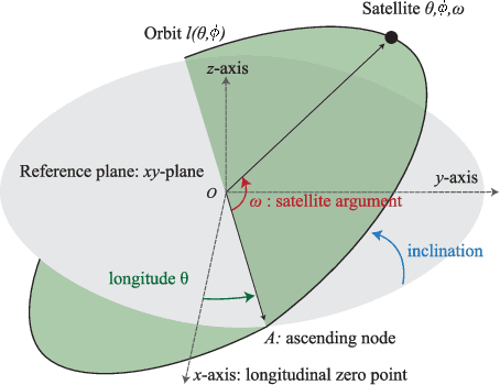
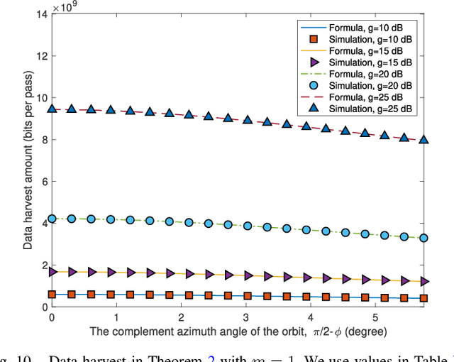
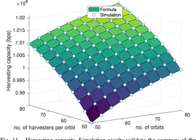
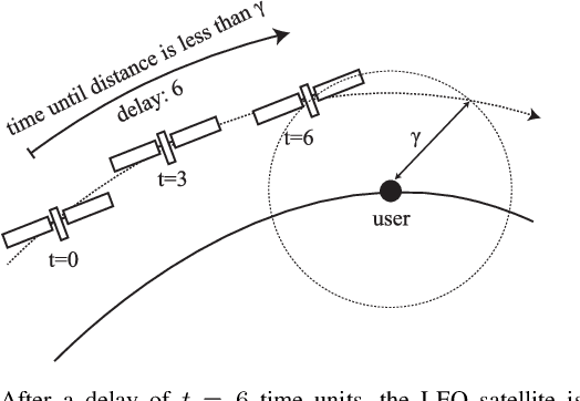
Abstract:Reaching all regions of Earth, low Earth orbit (LEO) satellites can harvest delay-tolerant data from remotely located users on Earth without ground infrastructure. This work aims to assess a data harvest network architecture where users generate data and LEO satellites harvest data from users when passing by. By developing a novel stochastic geometry Cox point process model that simultaneously generates orbits and the motion of LEO satellite harvesters on them, we analyze key performance indices of such a network by deriving the following: (i) the average fraction of time that the typical user is served by LEO satellite harvesters, (ii) the average amount of data uploaded per each satellite pass, (iii) the maximum harvesting capacity of the proposed network model, and (iv) the delay distribution in the proposed network. These key metrics are given as functions of key network variables such as $\lambda$ the mean number of orbits and $\mu$ the mean number of satellites per orbit. Providing rich comprehensive analytical results and practical interpretations of these results, this work assesses the potential of the delay-tolerant use of LEO satellites and also serves as a versatile framework to analyze, design, and optimize delay-tolerant LEO satellite networks.
* IEEE Journal on Selected Areas in Communications ( Volume: 42, Issue: 5, May 2024)
Stochastic Geometry Analysis of RIS-Assisted Cellular Networks with Reflective Intelligent Surfaces on Roads
Aug 09, 2024Abstract:Reconfigurable intelligent surfaces (RISs) provide alternative routes for reflected signals to network users, offering numerous applications. This paper explores an innovative approach of strategically deploying RISs along road areas to leverage various propagation and blockage conditions present in cellular networks with roads. To address the local network geometries shown by such networks, we use a stochastic geometry framework, specifically the Cox point processes, to model the locations of RISs and vehicle users. Then, we define the coverage probability as the chance that either a base station or an RIS is in line of sight (LOS) of the typical user and that the LOS signal has a signal-to-noise ratio (SNR) greater than a threshold. We derive the coverage probability as a function of key parameters such as RIS density and path loss exponent. We observe that the network geometry highly affects the coverage and that the proposed RIS deployment effectively leverages the underlying difference of attenuation and blockage, significantly increasing the coverage of vehicle users in the network. With experimental results addressing the impact of key variables to network performance, this work serves as a versatile tool for designing, analyzing, and optimizing RIS-assisted cellular networks with many vehicles.
Modeling and Analysis of Downlink Communications in a Heterogeneous LEO Satellite Network
Aug 09, 2024Abstract:Low Earth Orbit (LEO) satellite networks connect millions of devices on Earth and offer various services, such as data communications, remote sensing, and data harvesting. As the number of services increases, LEO satellite networks will continue to grow, and many LEO satellite network operators will share the same spectrum resources. We aim to examine the coexistence of such a future heterogeneous LEO satellite network by proposing a tractable spatial model and analyzing the basic performance of downlink communications. We model a heterogeneous LEO satellite network as Cox point processes, ensuring satellites are located on various orbits. Then, we analyze two different access technologies for such a heterogeneous satellite network: closed access and open access. For both cases, we derive the coverage probability and prove that the coverage probability of the open access scenario outperforms that of the closed access, and this coverage enhancement applies to all users. By providing essential network performance statistics as key distributional parameters and by presenting the fact that the Cox point process approximates a forthcoming future constellation with slight variation, the developed framework and analysis will serve as a tractable instrument to design, evaluate, and optimize heterogeneous LEO satellite networks with numerous constellations.
* IEEE Trans. Wireless Communications
Cox Point Processes for Multi-Altitude LEO Satellite Networks
Jan 06, 2023Abstract:We propose a simple analytical approach to describe the locations of low earth orbit (LEO) satellites based on a Cox point process. We develop a variable-altitude Poisson orbit process by accounting for the fact that satellites are always located on circular orbits and these orbits may have different altitudes. Then, the satellites on these orbits are modeled as the Poisson point processes conditionally on the orbit process. For this model, we derive the distribution of the distance to the nearest visible satellite, the outage probability, the Laplace functional of the proposed satellite Cox point process, and the Laplace transform of the interference under a general fading. The derived statistics allow one to evaluate the performance of such LEO satellite communication systems as functions of network parameters.
An Analytical Framework for Downlink LEO Satellite Communications based on Cox Point Processes
Dec 07, 2022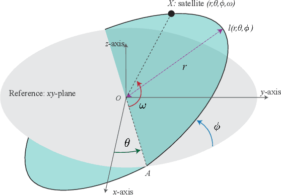
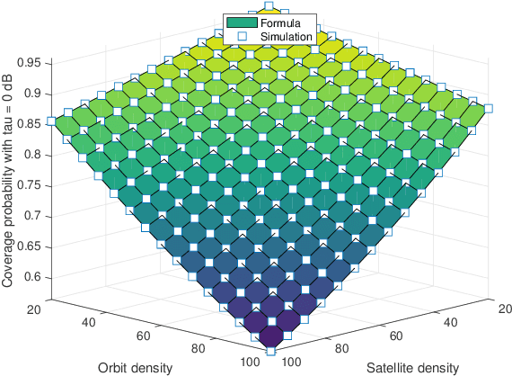
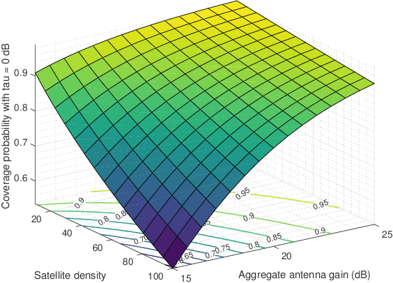
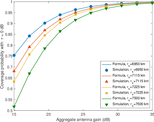
Abstract:This work develops an analytical framework for downlink low earth orbit (LEO) satellite communications, leveraging tools from stochastic geometry. We propose a tractable approach to the analysis of such satellite communication systems accounting for the fact that satellites are located on circular orbits. We accurately characterize this geometric property of such LEO satellite constellations by developing a Cox point process model that jointly produces orbits and satellites on these orbits. Our work differs from existing studies that have assumed satellites' locations as completely random binomial point processes. For this Cox model, we derive the outage probability of the proposed network and the distribution of the signal-to-interference-plus-noise ratio (SINR) of an arbitrarily located user in the network. By determining various network performance metrics as functions of key network parameters, this work allows one to assess the statistical properties of downlink LEO satellite communications and thus can be used as a system-level design tool.
Modeling and Analysis of 2-Tier Heterogeneous Vehicular Networks Leveraging Roadside Units and Vehicle Relays
Apr 26, 2022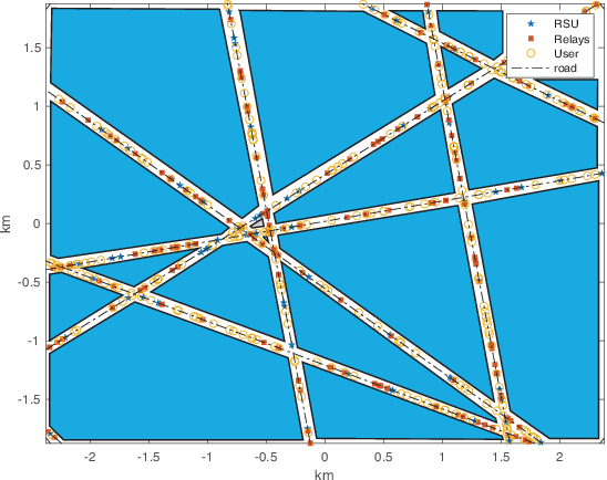
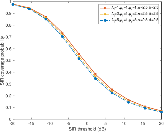
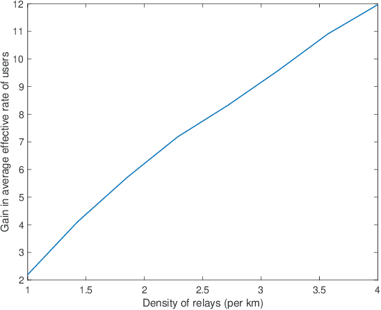
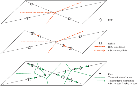
Abstract:While roadside units (RSUs) play an essential role in vehicle-to-everything (V2X) by communicating with users, some users in congestion areas may not be well-served due to data traffic, signal attenuation, and interference. In these cases, vehicle relays can be employed to enhance the network topology to better serve those users. This paper leverages stochastic geometry to propose a novel framework for the performance analysis of heterogeneous vehicular networks with RSUs, vehicle relays, and vehicle users. We present a two-dimensional analytical model where the spatial dependence between RSUs, vehicle relays, vehicle users, and roads is accurately taken into account through a Cox point process structure. Assuming relays are backhauled to RSUs over a reserved wireless resource and users are associated with the closest RSU or relay, we derive the probability that the typical user is associated with either an RSU or a relay. Then, we derive the signal-to-interference ratio (SIR) coverage probability of the typical user. Finally, using the derived formulas, we evaluate the average effective rate of the typical user in the network. This allows us to determine the gain of the average effective rate of users that results from the deployment of relays in the network.
An Analysis of LOS Coverage in Vehicular Networks with Roadside Units and Relays
Oct 26, 2021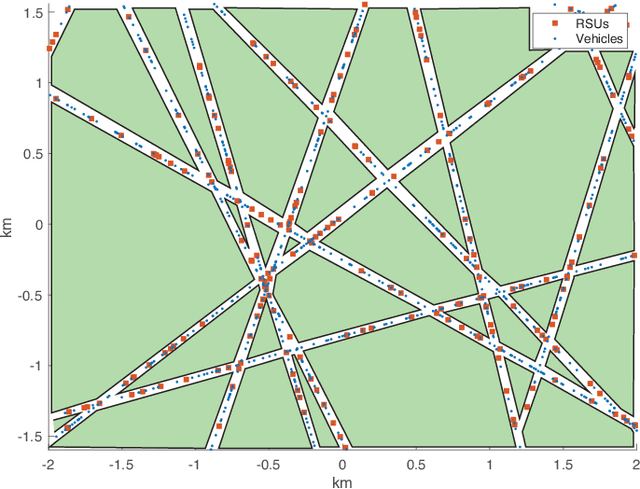
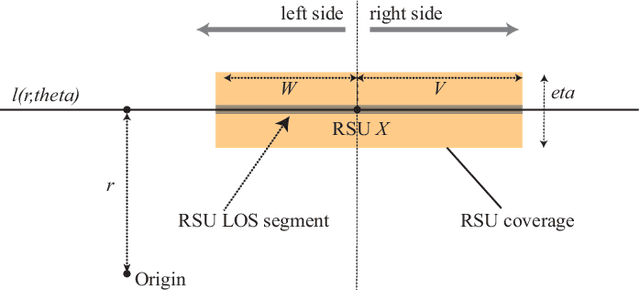
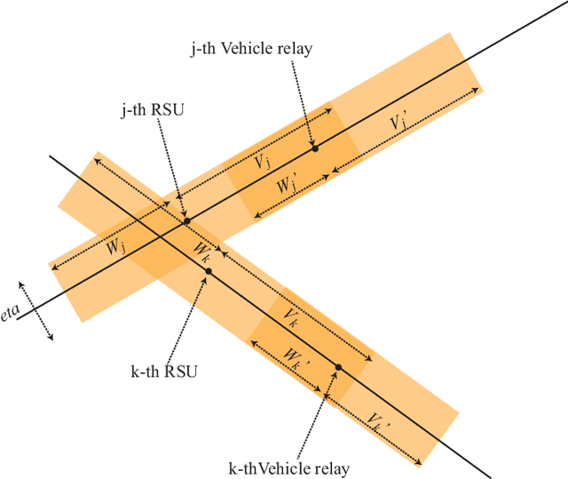
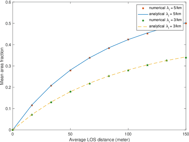
Abstract:This paper analyzes the use of vehicular relays as a means to extend the Line-of-Sight (LOS) coverage from roadside units(RSUs) toward users on the streets in mmWave or visible light communications. In this paper, we consider the scenario where RSUs select vehicles within their LOS coverage as relays. As a result, the LOS coverage of those RSUs is extended by the LOS coverage newly provided by the vehicular relays. To account for the spatial relationship between vehicles and RSUs, we use Cox point processes. We assume that the LOS distances from RSUs or relays are independent and exponentially distributed. To address the spatial interactions between RSU LOS coverage and relay LOS coverage, we use the notion of mean area fraction to evaluate the LOS coverage.
A Random Geometric Model of Blockages in Vehicular Networks
Aug 24, 2021

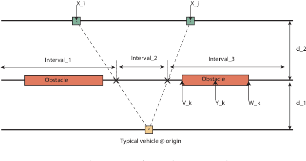
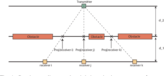
Abstract:This paper presents a novel spatially consistent approach for modeling line-of-sight (LOS) paths in vehicular networks. We use stochastic geometry to model transmitters, obstacles, and receivers located in three parallel lines, respectively. Their geometric interactions are leveraged to characterize the existence of LOS paths. Specifically, the proposed approach focuses on the role of obstacles in blocking one or more LOS paths, which has been overlooked in most statistical models for blockage. Under the proposed framework, we derive the probability that a typical vehicle is in LOS with respect to transmitters with received signal-to-noise ratios greater than a threshold. The proposed framework and LOS coverage analysis are instrumental to the analysis of LOS-critical applications such as positioning or mmWave communications in vehicular networks.
 Add to Chrome
 Add to Firefox
 Add to Edge