Anthony B. Davis
GEOSCAN: Global Earth Observation using Swarm of Coordinated Autonomous Nanosats
Nov 27, 2021


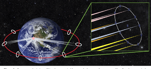
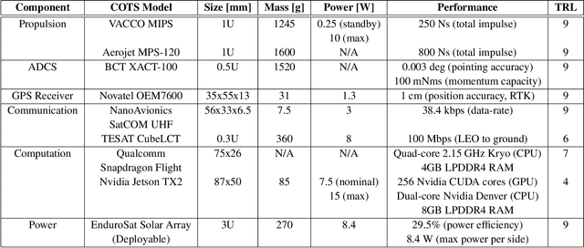
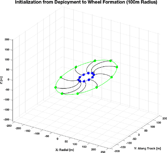
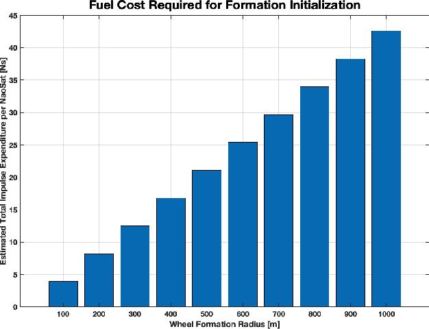
Abstract:The climate crisis we are facing calls for significant improvements in our understanding of natural phenomena, with clouds being identified as a dominant source of uncertainty. To this end, the emerging field of 3D computed cloud tomography (CCT) aims to more precisely characterize clouds by utilizing multi-dimensional imaging to reconstruct their outer and inner structure. In this paper, we propose a future Earth observation mission concept, driven by the needs of CCT, that operates constellation of NanoSats to provide multi-angular, spectrally-resolved, spatial and temporal scientific measurements of natural atmospheric phenomena. Our proposed mission, GEOSCAN, will on-board active steering capability to rapidly reconfigure networked swarm of autonomous Nanosats to track evolving phenomena of interest, on-demand, in real-time. We present the structure of the GEOSCAN constellation and discuss details of the mission concept from both science and engineering perspectives. On the science side, we outline the types of remote Earth observation measurements that GEOSCAN enables beyond the state-of-the-art, and how such measurements translate to improvements in CCT that can lead to reduction in uncertainty of the global climate models (GCMs). From the engineering side, we investigate feasibility of the concept starting from hardware components of the NanoSat that form the basis of the constellation. In particular, we focus on the active steering capability of the GEOSCAN with algorithmic approaches that enable coordination from new software. We identify technology gaps that need to be bridged and discuss other aspects of the mission that require in-depth analysis to further mature the concept.
Multi-view polarimetric scattering cloud tomography and retrieval of droplet size
May 22, 2020


Abstract:Tomography aims to recover a three-dimensional (3D) density map of a medium or an object. In medical imaging, it is extensively used for diagnostics via X-ray computed tomography (CT). Optical diffusion tomography is an alternative to X-ray CT that uses multiply scattered light to deliver coarse density maps for soft tissues. We define and derive tomography of cloud droplet distributions via passive remote sensing. We use multi-view polarimetric images to fit a 3D polarized radiative transfer (RT) forward model. Our motivation is 3D volumetric probing of vertically-developed convectively-driven clouds that are ill-served by current methods in operational passive remote sensing. These techniques are based on strictly 1D RT modeling and applied to a single cloudy pixel, where cloud geometry is assumed to be that of a plane-parallel slab. Incident unpolarized sunlight, once scattered by cloud-droplets, changes its polarization state according to droplet size. Therefore, polarimetric measurements in the rainbow and glory angular regions can be used to infer the droplet size distribution. This work defines and derives a framework for a full 3D tomography of cloud droplets for both their mass concentration in space and their distribution across a range of sizes. This 3D retrieval of key microphysical properties is made tractable by our novel approach that involves a restructuring and differentiation of an open-source polarized 3D RT code to accommodate a special two-step optimization technique. Physically-realistic synthetic clouds are used to demonstrate the methodology with rigorous uncertainty quantification.
 Add to Chrome
 Add to Firefox
 Add to Edge