Angela Busheska
TerraTrace: Temporal Signature Land Use Mapping System
Feb 25, 2025


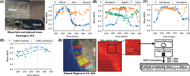
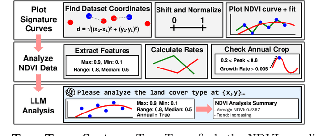
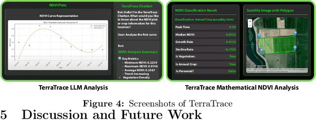
Abstract:Understanding land use over time is critical to tracking events related to climate change, like deforestation. However, satellite-based remote sensing tools which are used for monitoring struggle to differentiate vegetation types in farms and orchards from forests. We observe that metrics such as the Normalized Difference Vegetation Index (NDVI), based on plant photosynthesis, have unique temporal signatures that reflect agricultural practices and seasonal cycles. We analyze yearly NDVI changes on 20 farms for 10 unique crops. Initial results show that NDVI curves are coherent with agricultural practices, are unique to each crop, consistent globally, and can differentiate farms from forests. We develop a novel longitudinal NDVI dataset for the state of California from 2020-2023 with 500~m resolution and over 70 million points. We use this to develop the TerraTrace platform, an end-to-end analytic tool that classifies land use using NDVI signatures and allows users to query the system through an LLM chatbot and graphical interface.
Machine Learning and Thermography Applied to the Detection and Classification of Cracks in Building
Dec 30, 2022Abstract:Due to the environmental impacts caused by the construction industry, repurposing existing buildings and making them more energy-efficient has become a high-priority issue. However, a legitimate concern of land developers is associated with the buildings' state of conservation. For that reason, infrared thermography has been used as a powerful tool to characterize these buildings' state of conservation by detecting pathologies, such as cracks and humidity. Thermal cameras detect the radiation emitted by any material and translate it into temperature-color-coded images. Abnormal temperature changes may indicate the presence of pathologies, however, reading thermal images might not be quite simple. This research project aims to combine infrared thermography and machine learning (ML) to help stakeholders determine the viability of reusing existing buildings by identifying their pathologies and defects more efficiently and accurately. In this particular phase of this research project, we've used an image classification machine learning model of Convolutional Neural Networks (DCNN) to differentiate three levels of cracks in one particular building. The model's accuracy was compared between the MSX and thermal images acquired from two distinct thermal cameras and fused images (formed through multisource information) to test the influence of the input data and network on the detection results.
 Add to Chrome
 Add to Firefox
 Add to Edge