Will there be a construction? Predicting road constructions based on heterogeneous spatiotemporal data
Paper and Code
Sep 14, 2022


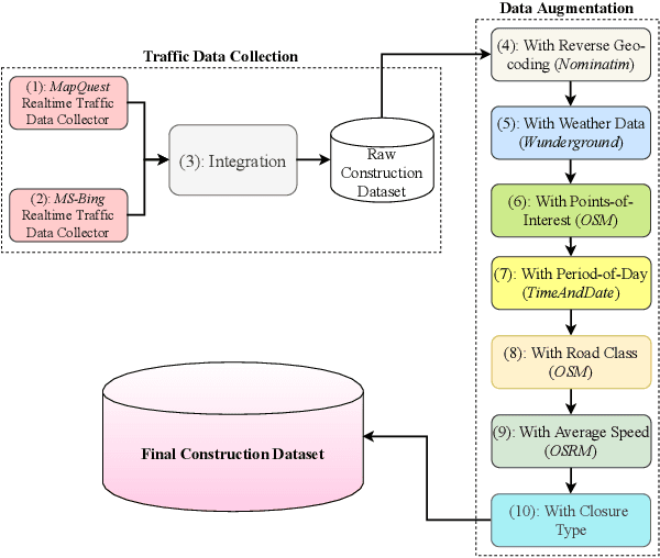
Road construction projects maintain transportation infrastructures. These projects range from the short-term (e.g., resurfacing or fixing potholes) to the long-term (e.g., adding a shoulder or building a bridge). Deciding what the next construction project is and when it is to be scheduled is traditionally done through inspection by humans using special equipment. This approach is costly and difficult to scale. An alternative is the use of computational approaches that integrate and analyze multiple types of past and present spatiotemporal data to predict location and time of future road constructions. This paper reports on such an approach, one that uses a deep-neural-network-based model to predict future constructions. Our model applies both convolutional and recurrent components on a heterogeneous dataset consisting of construction, weather, map and road-network data. We also report on how we addressed the lack of adequate publicly available data - by building a large scale dataset named "US-Constructions", that includes 6.2 million cases of road constructions augmented by a variety of spatiotemporal attributes and road-network features, collected in the contiguous United States (US) between 2016 and 2021. Using extensive experiments on several major cities in the US, we show the applicability of our work in accurately predicting future constructions - an average f1-score of 0.85 and accuracy 82.2% - that outperform baselines. Additionally, we show how our training pipeline addresses spatial sparsity of data.
 Add to Chrome
 Add to Firefox
 Add to Edge