Prioritizing Potential Wetland Areas via Region-to-Region Knowledge Transfer and Adaptive Propagation
Paper and Code
Jun 08, 2024


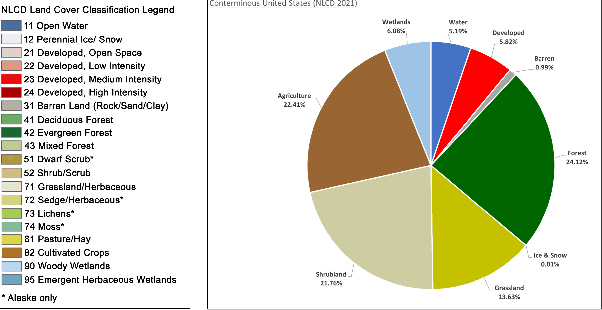
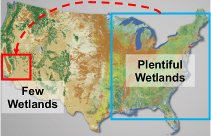
Wetlands are important to communities, offering benefits ranging from water purification, and flood protection to recreation and tourism. Therefore, identifying and prioritizing potential wetland areas is a critical decision problem. While data-driven solutions are feasible, this is complicated by significant data sparsity due to the low proportion of wetlands (3-6\%) in many areas of interest in the southwestern US. This makes it hard to develop data-driven models that can help guide the identification of additional wetland areas. To solve this limitation, we propose two strategies: (1) The first of these is knowledge transfer from regions with rich wetlands (such as the Eastern US) to sparser regions (such as the Southwestern area with few wetlands). Recognizing that these regions are likely to be very different from each other in terms of soil characteristics, population distribution, and land use, we propose a domain disentanglement strategy that identifies and transfers only the applicable aspects of the learned model. (2) We complement this with a spatial data enrichment strategy that relies on an adaptive propagation mechanism. This mechanism differentiates between node pairs that have positive and negative impacts on each other for Graph Neural Networks (GNNs). To summarize, given two spatial cells belonging to different regions, we identify domain-specific and domain-shareable features, and, for each region, we rely on adaptive propagation to enrich features with the features of surrounding cells. We conduct rigorous experiments to substantiate our proposed method's effectiveness, robustness, and scalability compared to state-of-the-art baselines. Additionally, an ablation study demonstrates that each module is essential in prioritizing potential wetlands, which justifies our assumption.
 Add to Chrome
 Add to Firefox
 Add to Edge