 Add to Chrome
 Add to Firefox
 Add to Edge
Variable Neighborhood Search for the Electric Vehicle Routing Problem
Nov 11, 2025The Electric Vehicle Routing Problem (EVRP) extends the classical Vehicle Routing Problem (VRP) to reflect the growing use of electric and hybrid vehicles in logistics. Due to the variety of constraints considered in the literature, comparing approaches across different problem variants remains challenging. A minimalistic variant of the EVRP, known as the Capacitated Green Vehicle Routing Problem (CGVRP), was the focus of the CEC-12 competition held during the 2020 IEEE World Congress on Computational Intelligence. This paper presents the competition-winning approach, based on the Variable Neighborhood Search (VNS) metaheuristic. The method achieves the best results on the full competition dataset and also outperforms a more recent algorithm published afterward.
Detailed Aerial Mapping of Photovoltaic Power Plants Through Semantically Significant Keypoints
Oct 06, 2025An accurate and up-to-date model of a photovoltaic (PV) power plant is essential for its optimal operation and maintenance. However, such a model may not be easily available. This work introduces a novel approach for PV power plant mapping based on aerial overview images. It enables the automation of the mapping process while removing the reliance on third-party data. The presented mapping method takes advantage of the structural layout of the power plants to achieve detailed modeling down to the level of individual PV modules. The approach relies on visual segmentation of PV modules in overview images and the inference of structural information in each image, assigning modules to individual benches, rows, and columns. We identify visual keypoints related to the layout and use these to merge detections from multiple images while maintaining their structural integrity. The presented method was experimentally verified and evaluated on two different power plants. The final fusion of 3D positions and semantic structures results in a compact georeferenced model suitable for power plant maintenance.
Visual Localization via Semantic Structures in Autonomous Photovoltaic Power Plant Inspection
Jan 24, 2025


Inspection systems utilizing unmanned aerial vehicles (UAVs) equipped with thermal cameras are increasingly popular for the maintenance of photovoltaic (PV) power plants. However, automation of the inspection task is a challenging problem as it requires precise navigation to capture images from optimal distances and viewing angles. This paper presents a novel localization pipeline that directly integrates PV module detection with UAV navigation, allowing precise positioning during inspection. Detections are used to identify the power plant structures in the image and associate these with the power plant model. We define visually recognizable anchor points for the initial association and use object tracking to discern global associations. We present three distinct methods for visual segmentation of PV modules based on traditional computer vision, deep learning, and their fusion, and we evaluate their performance in relation to the proposed localization pipeline. The presented methods were verified and evaluated using custom aerial inspection data sets, demonstrating their robustness and applicability for real-time navigation. Additionally, we evaluate the influence of the power plant model's precision on the localization methods.
An Integrated Approach to Autonomous Environment Modeling
Jan 22, 2019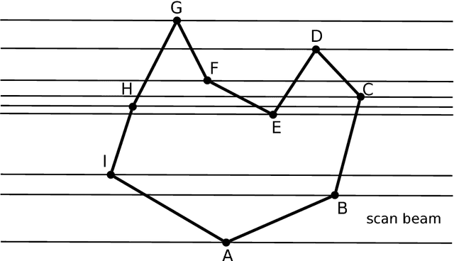
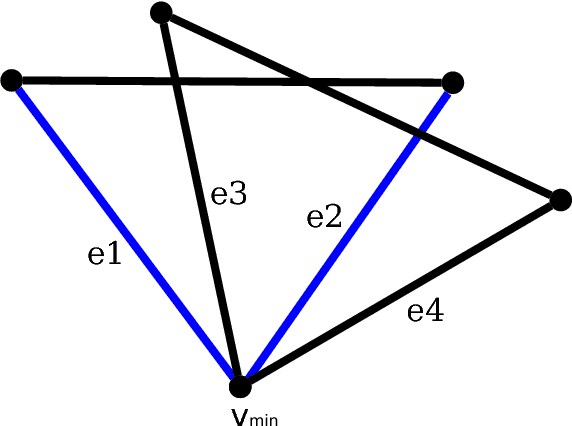
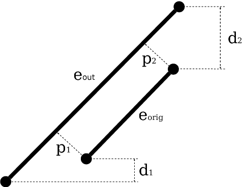
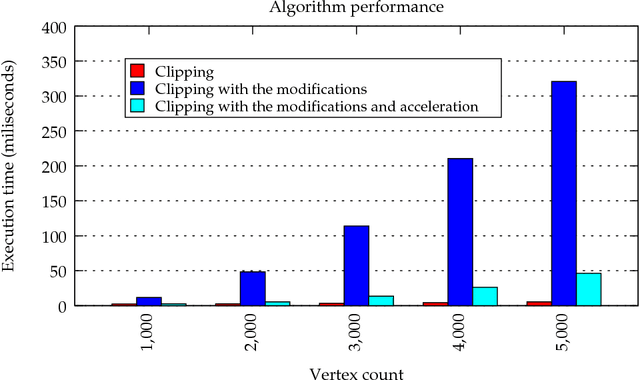
In this paper, we present an integrated solution to memory-efficient environment modeling by an autonomous mobile robot equipped with a laser range-finder. Majority of nowadays approaches to autonomous environment modeling, called exploration, employs occupancy grids as environment representation where the working space is divided into small cells each storing information about the corresponding piece of the environment in the form of a probabilistic estimate of its state. In contrast, the presented approach uses a polygonal representation of the explored environment which consumes much less memory, enables fast planning and decision-making algorithms and it is thus reliable for large-scale environments. Simultaneous localization and mapping (SLAM) has been integrated into the presented framework to correct odometry errors and to provide accurate position estimates. This involves also a refinement of the already generated environment model in case of loop closure, i.e. when the robot detects that it revisited an already explored place. The framework has been implemented in Robot Operating System (ROS) and tested with a real robot in various environments. The experiments show that the polygonal representation with SLAM integrated can be used in the real world as it is fast, memory efficient and accurate. Moreover, the refinement can be executed in real-time during the exploration process.