Sully Chen
The ASNR-MICCAI Brain Tumor Segmentation (BraTS) Challenge 2023: Intracranial Meningioma
May 12, 2023


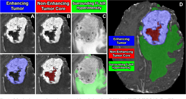
Abstract:Meningiomas are the most common primary intracranial tumor in adults and can be associated with significant morbidity and mortality. Radiologists, neurosurgeons, neuro-oncologists, and radiation oncologists rely on multiparametric MRI (mpMRI) for diagnosis, treatment planning, and longitudinal treatment monitoring; yet automated, objective, and quantitative tools for non-invasive assessment of meningiomas on mpMRI are lacking. The BraTS meningioma 2023 challenge will provide a community standard and benchmark for state-of-the-art automated intracranial meningioma segmentation models based on the largest expert annotated multilabel meningioma mpMRI dataset to date. Challenge competitors will develop automated segmentation models to predict three distinct meningioma sub-regions on MRI including enhancing tumor, non-enhancing tumor core, and surrounding nonenhancing T2/FLAIR hyperintensity. Models will be evaluated on separate validation and held-out test datasets using standardized metrics utilized across the BraTS 2023 series of challenges including the Dice similarity coefficient and Hausdorff distance. The models developed during the course of this challenge will aid in incorporation of automated meningioma MRI segmentation into clinical practice, which will ultimately improve care of patients with meningioma.
Satellite Monitoring of Terrestrial Plastic Waste
Mar 24, 2022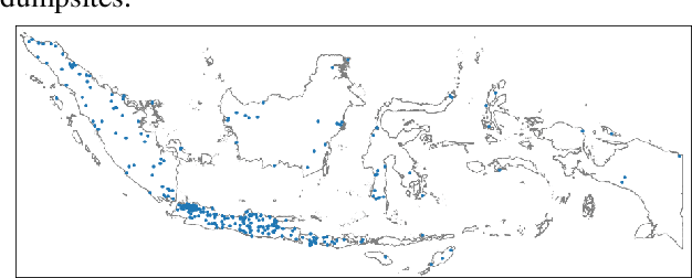
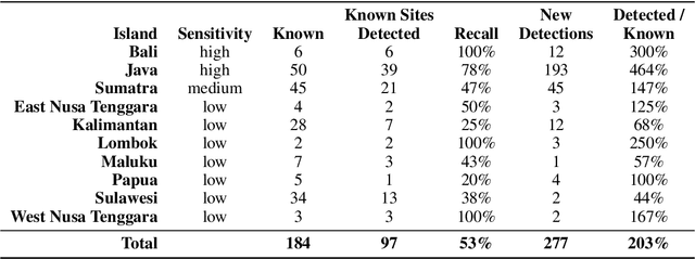
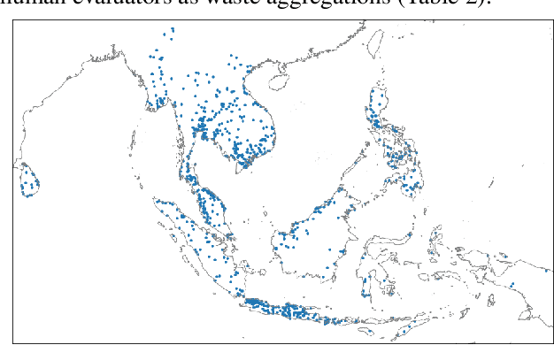
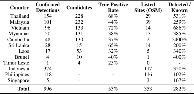
Abstract:Plastic waste is a significant environmental pollutant that is difficult to monitor. We created a system of neural networks to analyze spectral, spatial, and temporal components of Sentinel-2 satellite data to identify terrestrial aggregations of waste. The system works at continental scale. We evaluated performance in Indonesia and detected 374 waste aggregations, more than double the number of sites found in public databases. The same system deployed across twelve countries in Southeast Asia identifies 996 subsequently confirmed waste sites. For each detected site, we algorithmically monitor waste site footprints through time and cross-reference other datasets to generate physical and social metadata. 19% of detected waste sites are located within 200 m of a waterway. Numerous sites sit directly on riverbanks, with high risk of ocean leakage.
 Add to Chrome
 Add to Firefox
 Add to Edge