 Add to Chrome
 Add to Firefox
 Add to Edge
Self-Supervised Large Scale Point Cloud Completion for Archaeological Site Restoration
Mar 06, 2025Point cloud completion helps restore partial incomplete point clouds suffering occlusions. Current self-supervised methods fail to give high fidelity completion for large objects with missing surfaces and unbalanced distribution of available points. In this paper, we present a novel method for restoring large-scale point clouds with limited and imbalanced ground-truth. Using rough boundary annotations for a region of interest, we project the original point clouds into a multiple-center-of-projection (MCOP) image, where fragments are projected to images of 5 channels (RGB, depth, and rotation). Completion of the original point cloud is reduced to inpainting the missing pixels in the MCOP images. Due to lack of complete structures and an unbalanced distribution of existing parts, we develop a self-supervised scheme which learns to infill the MCOP image with points resembling existing "complete" patches. Special losses are applied to further enhance the regularity and consistency of completed MCOP images, which is mapped back to 3D to form final restoration. Extensive experiments demonstrate the superiority of our method in completing 600+ incomplete and unbalanced archaeological structures in Peru.
Semi-Supervised Contrastive Learning for Remote Sensing: Identifying Ancient Urbanization in the South Central Andes
Dec 13, 2021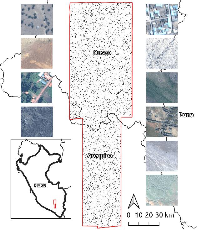
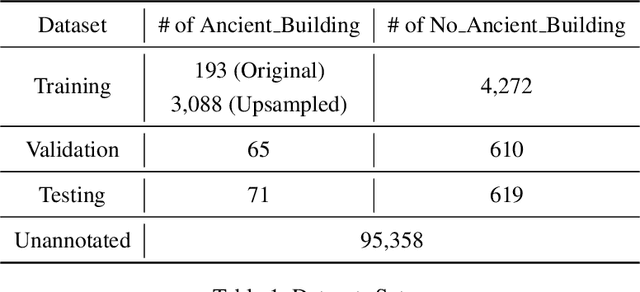
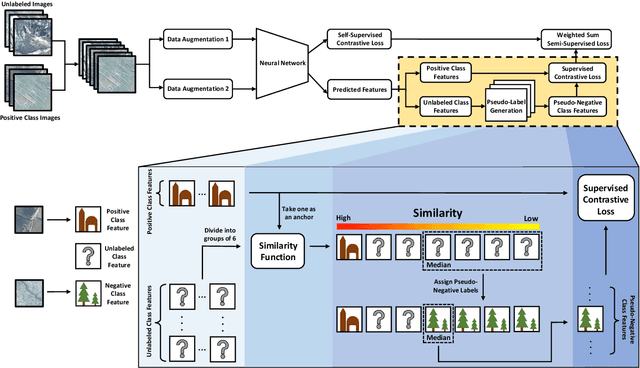
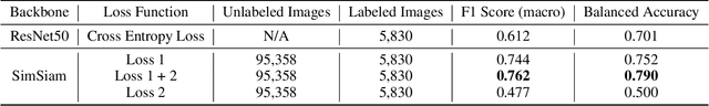
The detection of ancient settlements is a key focus in landscape archaeology. Traditionally, settlements were identified through pedestrian survey, as researchers physically traversed the landscape and recorded settlement locations. Recently the manual identification and labeling of ancient remains in satellite imagery have increased the scale of archaeological data collection, but the process remains tremendously time-consuming and arduous. The development of self-supervised learning (e.g., contrastive learning) offers a scalable learning scheme in locating archaeological sites using unlabeled satellite and historical aerial images. However, archaeology sites are only present in a very small proportion of the whole landscape, while the modern contrastive-supervised learning approach typically yield inferior performance on the highly balanced dataset, such as identifying sparsely localized ancient urbanization on a large area using satellite images. In this work, we propose a framework to solve this long-tail problem. As opposed to the existing contrastive learning approaches that typically treat the labeled and unlabeled data separately, the proposed method reforms the learning paradigm under a semi-supervised setting to fully utilize the precious annotated data (<7% in our setting). Specifically, the highly unbalanced nature of the data is employed as the prior knowledge to form pseudo negative pairs by ranking the similarities between unannotated image patches and annotated anchor images. In this study, we used 95,358 unlabeled images and 5,830 labeled images to solve the problem of detecting ancient buildings from a long-tailed satellite image dataset. From the results, our semi-supervised contrastive learning model achieved a promising testing balanced accuracy of 79.0%, which is 3.8% improvement over state-of-the-art approaches.