 Add to Chrome
 Add to Firefox
 Add to Edge
Photometric Redshift Estimation Using Scaled Ensemble Learning
Jan 12, 2026The development of the state-of-the-art telescopic systems capable of performing expansive sky surveys such as the Sloan Digital Sky Survey, Euclid, and the Rubin Observatory's Legacy Survey of Space and Time (LSST) has significantly advanced efforts to refine cosmological models. These advances offer deeper insight into persistent challenges in astrophysics and our understanding of the Universe's evolution. A critical component of this progress is the reliable estimation of photometric redshifts (Pz). To improve the precision and efficiency of such estimations, the application of machine learning (ML) techniques to large-scale astronomical datasets has become essential. This study presents a new ensemble-based ML framework aimed at predicting Pz for faint galaxies and higher redshift ranges, relying solely on optical (grizy) photometric data. The proposed architecture integrates several learning algorithms, including gradient boosting machine, extreme gradient boosting, k-nearest neighbors, and artificial neural networks, within a scaled ensemble structure. By using bagged input data, the ensemble approach delivers improved predictive performance compared to stand-alone models. The framework demonstrates consistent accuracy in estimating redshifts, maintaining strong performance up to z ~ 4. The model is validated using publicly available data from the Hyper Suprime-Cam Strategic Survey Program by the Subaru Telescope. Our results show marked improvements in the precision and reliability of Pz estimation. Furthermore, this approach closely adheres to-and in certain instances exceeds-the benchmarks specified in the LSST Science Requirements Document. Evaluation metrics include catastrophic outlier, bias, and rms.
* 10 pages, 2 figures, 3 tables
Understanding Urban Water Consumption using Remotely Sensed Data
May 03, 2022


Urban metabolism is an active field of research that deals with the estimation of emissions and resource consumption from urban regions. The analysis could be carried out through a manual surveyor by the implementation of elegant machine learning algorithms. In this exploratory work, we estimate the water consumption by the buildings in the region captured by satellite imagery. To this end, we break our analysis into three parts: i) Identification of building pixels, given a satellite image, followed by ii) identification of the building type (residential/non-residential) from the building pixels, and finally iii) using the building pixels along with their type to estimate the water consumption using the average per unit area consumption for different building types as obtained from municipal surveys.
Human Assisted Artificial Intelligence Based Technique to Create Natural Features for OpenStreetMap
Jul 08, 2020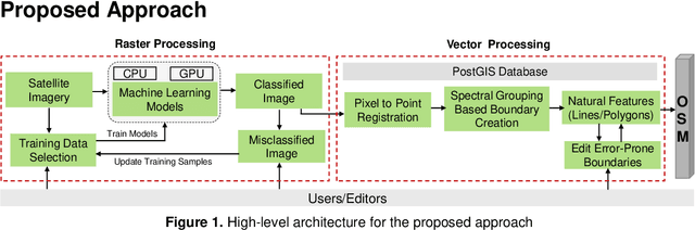

In this work, we propose an AI-based technique using freely available satellite images like Landsat and Sentinel to create natural features over OSM in congruence with human editors acting as initiators and validators. The method is based on Interactive Machine Learning technique where human inputs are coupled with the machine to solve complex problems efficiently as compare to pure autonomous process. We use a bottom-up approach where a machine learning (ML) pipeline in loop with editors is used to extract classes using spectral signatures of images and later convert them to editable features to create natural features.