Rafael Pires de Lima
Investigating the Effect of Spatial Context on Multi-Task Sea Ice Segmentation
Jul 28, 2025Abstract:Capturing spatial context at multiple scales is crucial for deep learning-based sea ice segmentation. However, the optimal specification of spatial context based on observation resolution and task characteristics remains underexplored. This study investigates the impact of spatial context on the segmentation of sea ice concentration, stage of development, and floe size using a multi-task segmentation model. We implement Atrous Spatial Pyramid Pooling with varying atrous rates to systematically control the receptive field size of convolutional operations, and to capture multi-scale contextual information. We explore the interactions between spatial context and feature resolution for different sea ice properties and examine how spatial context influences segmentation performance across different input feature combinations from Sentinel-1 SAR and Advanced Microwave Radiometer-2 (AMSR2) for multi-task mapping. Using Gradient-weighted Class Activation Mapping, we visualize how atrous rates influence model decisions. Our findings indicate that smaller receptive fields excel for high-resolution Sentinel-1 data, while medium receptive fields yield better performances for stage of development segmentation and larger receptive fields often lead to diminished performances. The fusion of SAR and AMSR2 enhances segmentation across all tasks. We highlight the value of lower-resolution 18.7 and 36.5 GHz AMSR2 channels in sea ice mapping. These findings highlight the importance of selecting appropriate spatial context based on observation resolution and target properties in sea ice mapping. By systematically analyzing receptive field effects in a multi-task setting, our study provides insights for optimizing deep learning models in geospatial applications.
Comparison of Cross-Entropy, Dice, and Focal Loss for Sea Ice Type Segmentation
Oct 26, 2023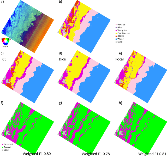
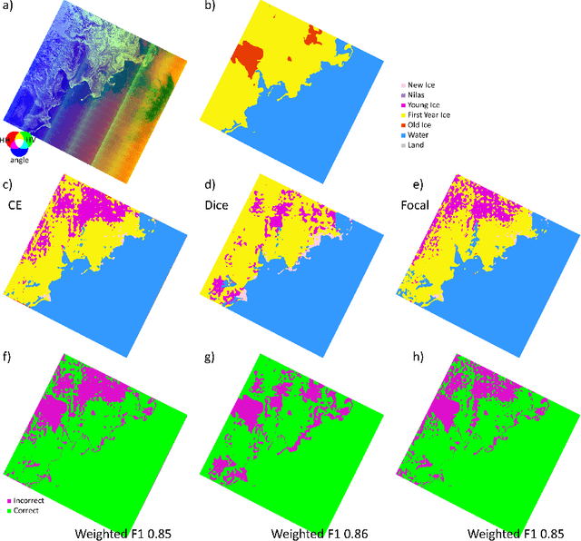
Abstract:Up-to-date sea ice charts are crucial for safer navigation in ice-infested waters. Recently, Convolutional Neural Network (CNN) models show the potential to accelerate the generation of ice maps for large regions. However, results from CNN models still need to undergo scrutiny as higher metrics performance not always translate to adequate outputs. Sea ice type classes are imbalanced, requiring special treatment during training. We evaluate how three different loss functions, some developed for imbalanced class problems, affect the performance of CNN models trained to predict the dominant ice type in Sentinel-1 images. Despite the fact that Dice and Focal loss produce higher metrics, results from cross-entropy seem generally more physically consistent.
Enhancing sea ice segmentation in Sentinel-1 images with atrous convolutions
Oct 26, 2023Abstract:Due to the growing volume of remote sensing data and the low latency required for safe marine navigation, machine learning (ML) algorithms are being developed to accelerate sea ice chart generation, currently a manual interpretation task. However, the low signal-to-noise ratio of the freely available Sentinel-1 Synthetic Aperture Radar (SAR) imagery, the ambiguity of backscatter signals for ice types, and the scarcity of open-source high-resolution labelled data makes automating sea ice mapping challenging. We use Extreme Earth version 2, a high-resolution benchmark dataset generated for ML training and evaluation, to investigate the effectiveness of ML for automated sea ice mapping. Our customized pipeline combines ResNets and Atrous Spatial Pyramid Pooling for SAR image segmentation. We investigate the performance of our model for: i) binary classification of sea ice and open water in a segmentation framework; and ii) a multiclass segmentation of five sea ice types. For binary ice-water classification, models trained with our largest training set have weighted F1 scores all greater than 0.95 for January and July test scenes. Specifically, the median weighted F1 score was 0.98, indicating high performance for both months. By comparison, a competitive baseline U-Net has a weighted average F1 score of ranging from 0.92 to 0.94 (median 0.93) for July, and 0.97 to 0.98 (median 0.97) for January. Multiclass ice type classification is more challenging, and even though our models achieve 2% improvement in weighted F1 average compared to the baseline U-Net, test weighted F1 is generally between 0.6 and 0.80. Our approach can efficiently segment full SAR scenes in one run, is faster than the baseline U-Net, retains spatial resolution and dimension, and is more robust against noise compared to approaches that rely on patch classification.
Deep Learning on SAR Imagery: Transfer Learning Versus Randomly Initialized Weights
Oct 26, 2023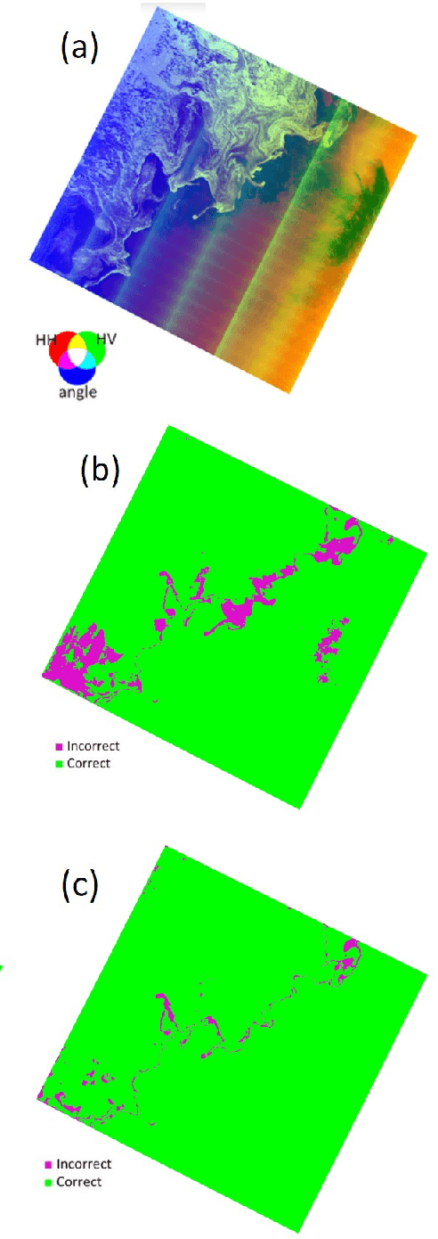
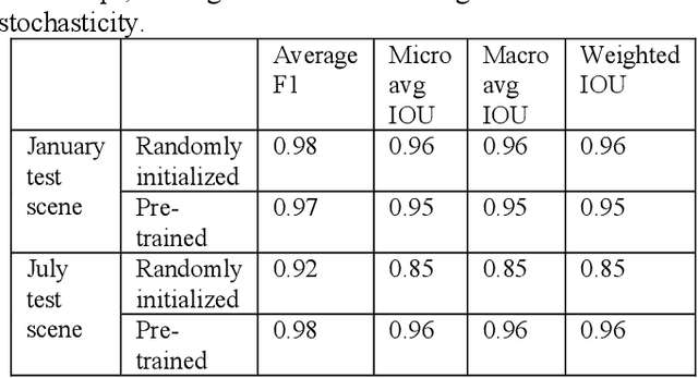
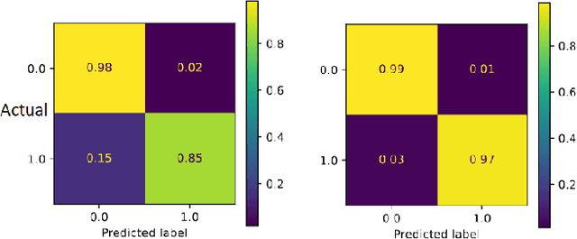

Abstract:Deploying deep learning on Synthetic Aperture Radar (SAR) data is becoming more common for mapping purposes. One such case is sea ice, which is highly dynamic and rapidly changes as a result of the combined effect of wind, temperature, and ocean currents. Therefore, frequent mapping of sea ice is necessary to ensure safe marine navigation. However, there is a general shortage of expert-labeled data to train deep learning algorithms. Fine-tuning a pre-trained model on SAR imagery is a potential solution. In this paper, we compare the performance of deep learning models trained from scratch using randomly initialized weights against pre-trained models that we fine-tune for this purpose. Our results show that pre-trained models lead to better results, especially on test samples from the melt season.
 Add to Chrome
 Add to Firefox
 Add to Edge