Peiqi Jin
Developing Flying Explorer for Autonomous Digital Modelling in Wild Unknowns
Dec 29, 2023


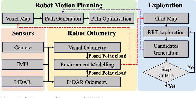
Abstract:This work presents an innovative solution for robotic odometry, path planning and exploration in wild unknown environments, focusing on digital modelling. The approach uses a minimum cost formulation with pseudo-randomly generated objectives, integrating multi-path planning and evaluation, with emphasis on full coverage of unknown maps based on feasible boundaries of interest. The evaluation carried out on a robotic platform with a lightweight 3D LiDAR sensor model, assesses the consistency and efficiency in exploring completely unknown subterranean-like areas. The algorithm allows for dynamic changes to the desired target and behaviour. At the same time, the paper details the design of AREX, highlighting its robust localisation, mapping and efficient exploration target selection capabilities, with a focus on continuity in exploration direction for increased efficiency and reduced odometry errors. The real-time, high-precision environmental perception module is identified as critical for accurate obstacle avoidance and exploration boundary identification.
 Add to Chrome
 Add to Firefox
 Add to Edge