 Add to Chrome
 Add to Firefox
 Add to Edge
Beyond Coverage Path Planning: Can UAV Swarms Perfect Scattered Regions Inspections?
Dec 29, 2025Unmanned Aerial Vehicles (UAVs) have revolutionized inspection tasks by offering a safer, more efficient, and flexible alternative to traditional methods. However, battery limitations often constrain their effectiveness, necessitating the development of optimized flight paths and data collection techniques. While existing approaches like coverage path planning (CPP) ensure comprehensive data collection, they can be inefficient, especially when inspecting multiple non connected Regions of Interest (ROIs). This paper introduces the Fast Inspection of Scattered Regions (FISR) problem and proposes a novel solution, the multi UAV Disjoint Areas Inspection (mUDAI) method. The introduced approach implements a two fold optimization procedure, for calculating the best image capturing positions and the most efficient UAV trajectories, balancing data resolution and operational time, minimizing redundant data collection and resource consumption. The mUDAI method is designed to enable rapid, efficient inspections of scattered ROIs, making it ideal for applications such as security infrastructure assessments, agricultural inspections, and emergency site evaluations. A combination of simulated evaluations and real world deployments is used to validate and quantify the method's ability to improve operational efficiency while preserving high quality data capture, demonstrating its effectiveness in real world operations. An open source Python implementation of the mUDAI method can be found on GitHub (https://github.com/soc12/mUDAI) and the collected and processed data from the real world experiments are all hosted on Zenodo (https://zenodo.org/records/13866483). Finally, this online platform (https://sites.google.com/view/mudai-platform/) allows interested readers to interact with the mUDAI method and generate their own multi UAV FISR missions.
Terrain-Aware Adaptation for Two-Dimensional UAV Path Planners
Jul 24, 2025Multi-UAV Coverage Path Planning (mCPP) algorithms in popular commercial software typically treat a Region of Interest (RoI) only as a 2D plane, ignoring important3D structure characteristics. This leads to incomplete 3Dreconstructions, especially around occluded or vertical surfaces. In this paper, we propose a modular algorithm that can extend commercial two-dimensional path planners to facilitate terrain-aware planning by adjusting altitude and camera orientations. To demonstrate it, we extend the well-known DARP (Divide Areas for Optimal Multi-Robot Coverage Path Planning) algorithm and produce DARP-3D. We present simulation results in multiple 3D environments and a real-world flight test using DJI hardware. Compared to baseline, our approach consistently captures improved 3D reconstructions, particularly in areas with significant vertical features. An open-source implementation of the algorithm is available here:https://github.com/konskara/TerraPlan
Cooperative Multi-UAV Coverage Mission Planning Platform for Remote Sensing Applications
Jan 19, 2022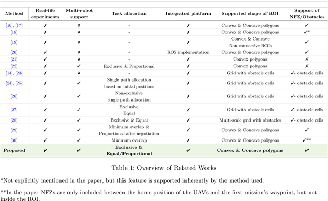


This paper proposes a novel mission planning platform, capable of efficiently deploying a team of UAVs to cover complex-shaped areas, in various remote sensing applications. Under the hood lies a novel optimization scheme for grid-based methods, utilizing Simulated Annealing algorithm, that significantly increases the achieved percentage of coverage and improves the qualitative features of the generated paths. Extensive simulated evaluation in comparison with a state-of-the-art alternative methodology, for coverage path planning (CPP) operations, establishes the performance gains in terms of achieved coverage and overall duration of the generated missions. On top of that, DARP algorithm is employed to allocate sub-tasks to each member of the swarm, taking into account each UAV's sensing and operational capabilities, their initial positions and any no-fly-zones possibly defined inside the operational area. This feature is of paramount importance in real-life applications, as it has the potential to achieve tremendous performance improvements in terms of time demanded to complete a mission, while at the same time it unlocks a wide new range of applications, that was previously not feasible due to the limited battery life of UAVs. In order to investigate the actual efficiency gains that are introduced by the multi-UAV utilization, a simulated study is performed as well. All of these capabilities are packed inside an end-to-end platform that eases the utilization of UAVs' swarms in remote sensing applications. Its versatility is demonstrated via two different real-life applications: (i) a photogrametry for precision agriculture and (ii) an indicative search and rescue for first responders missions, that were performed utilizing a swarm of commercial UAVs. The source code can be found at: https://github.com/savvas-ap/mCPP-optimized-DARP
* An implementation of the mCPP methodology introduced in this work, as well as a link for a demonstrative video and a link for a fully functional, on-line hosted instance of the presented platform can be found here: https://github.com/savvas-ap/mCPP-optimized-DARP