Mateo Neira
Graph representation learning for street networks
Nov 09, 2022Abstract:Streets networks provide an invaluable source of information about the different temporal and spatial patterns emerging in our cities. These streets are often represented as graphs where intersections are modelled as nodes and streets as links between them. Previous work has shown that raster representations of the original data can be created through a learning algorithm on low-dimensional representations of the street networks. In contrast, models that capture high-level urban network metrics can be trained through convolutional neural networks. However, the detailed topological data is lost through the rasterisation of the street network. The models cannot recover this information from the image alone, failing to capture complex street network features. This paper proposes a model capable of inferring good representations directly from the street network. Specifically, we use a variational autoencoder with graph convolutional layers and a decoder that outputs a probabilistic fully-connected graph to learn latent representations that encode both local network structure and the spatial distribution of nodes. We train the model on thousands of street network segments and use the learnt representations to generate synthetic street configurations. Finally, we proposed a possible application to classify the urban morphology of different network segments by investigating their common characteristics in the learnt space.
Learning from Discovering: An unsupervised approach to Geographical Knowledge Discovery using street level and street network images
Jun 18, 2019


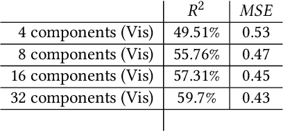
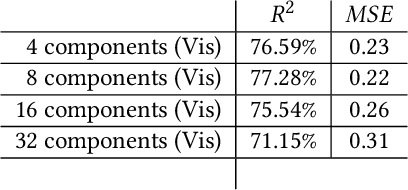
Abstract:Recent researches have shown the increasing use of machine learning methods in geography and urban analytics, primarily to extract features and patterns from spatial and temporal data. Research, integrating geographical processes in machine learning models and, leveraging on geographical information to better interpret these methods had been sparse. This research contributes to the ladder, where we show how latent variables learned from unsupervised learning methods can be used for geographic knowledge discovery. In particular, we propose a simple and novel approach called Convolutional-PCA (ConvPCA) which are applied on both street level and street network images in finding a set of uncorrelated visual latent responses. The approach allows for meaningful explanations using a combination of, geographical and generative visualizations to explore the latent space, and to show how the learned embeddings can be used to predict urban characteristics such as street-level enclosures and street network density.
 Add to Chrome
 Add to Firefox
 Add to Edge