Mark Mulligan
AdaTreeFormer: Few Shot Domain Adaptation for Tree Counting from a Single High-Resolution Image
Feb 05, 2024


Abstract:The process of estimating and counting tree density using only a single aerial or satellite image is a difficult task in the fields of photogrammetry and remote sensing. However, it plays a crucial role in the management of forests. The huge variety of trees in varied topography severely hinders tree counting models to perform well. The purpose of this paper is to propose a framework that is learnt from the source domain with sufficient labeled trees and is adapted to the target domain with only a limited number of labeled trees. Our method, termed as AdaTreeFormer, contains one shared encoder with a hierarchical feature extraction scheme to extract robust features from the source and target domains. It also consists of three subnets: two for extracting self-domain attention maps from source and target domains respectively and one for extracting cross-domain attention maps. For the latter, an attention-to-adapt mechanism is introduced to distill relevant information from different domains while generating tree density maps; a hierarchical cross-domain feature alignment scheme is proposed that progressively aligns the features from the source and target domains. We also adopt adversarial learning into the framework to further reduce the gap between source and target domains. Our AdaTreeFormer is evaluated on six designed domain adaptation tasks using three tree counting datasets, ie Jiangsu, Yosemite, and London; and outperforms the state of the art methods significantly.
TreeFormer: a Semi-Supervised Transformer-based Framework for Tree Counting from a Single High Resolution Image
Jul 12, 2023Abstract:Automatic tree density estimation and counting using single aerial and satellite images is a challenging task in photogrammetry and remote sensing, yet has an important role in forest management. In this paper, we propose the first semisupervised transformer-based framework for tree counting which reduces the expensive tree annotations for remote sensing images. Our method, termed as TreeFormer, first develops a pyramid tree representation module based on transformer blocks to extract multi-scale features during the encoding stage. Contextual attention-based feature fusion and tree density regressor modules are further designed to utilize the robust features from the encoder to estimate tree density maps in the decoder. Moreover, we propose a pyramid learning strategy that includes local tree density consistency and local tree count ranking losses to utilize unlabeled images into the training process. Finally, the tree counter token is introduced to regulate the network by computing the global tree counts for both labeled and unlabeled images. Our model was evaluated on two benchmark tree counting datasets, Jiangsu, and Yosemite, as well as a new dataset, KCL-London, created by ourselves. Our TreeFormer outperforms the state of the art semi-supervised methods under the same setting and exceeds the fully-supervised methods using the same number of labeled images. The codes and datasets are available at https://github.com/HAAClassic/TreeFormer.
Dam reservoir extraction from remote sensing imagery using tailored metric learning strategies
Jul 12, 2022


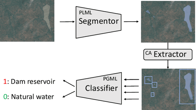
Abstract:Dam reservoirs play an important role in meeting sustainable development goals and global climate targets. However, particularly for small dam reservoirs, there is a lack of consistent data on their geographical location. To address this data gap, a promising approach is to perform automated dam reservoir extraction based on globally available remote sensing imagery. It can be considered as a fine-grained task of water body extraction, which involves extracting water areas in images and then separating dam reservoirs from natural water bodies. We propose a novel deep neural network (DNN) based pipeline that decomposes dam reservoir extraction into water body segmentation and dam reservoir recognition. Water bodies are firstly separated from background lands in a segmentation model and each individual water body is then predicted as either dam reservoir or natural water body in a classification model. For the former step, point-level metric learning with triplets across images is injected into the segmentation model to address contour ambiguities between water areas and land regions. For the latter step, prior-guided metric learning with triplets from clusters is injected into the classification model to optimize the image embedding space in a fine-grained level based on reservoir clusters. To facilitate future research, we establish a benchmark dataset with earth imagery data and human labelled reservoirs from river basins in West Africa and India. Extensive experiments were conducted on this benchmark in the water body segmentation task, dam reservoir recognition task, and the joint dam reservoir extraction task. Superior performance has been observed in the respective tasks when comparing our method with state of the art approaches.
 Add to Chrome
 Add to Firefox
 Add to Edge