Mario Rüttgers
HydroGym: A Reinforcement Learning Platform for Fluid Dynamics
Dec 19, 2025Abstract:Modeling and controlling fluid flows is critical for several fields of science and engineering, including transportation, energy, and medicine. Effective flow control can lead to, e.g., lift increase, drag reduction, mixing enhancement, and noise reduction. However, controlling a fluid faces several significant challenges, including high-dimensional, nonlinear, and multiscale interactions in space and time. Reinforcement learning (RL) has recently shown great success in complex domains, such as robotics and protein folding, but its application to flow control is hindered by a lack of standardized benchmark platforms and the computational demands of fluid simulations. To address these challenges, we introduce HydroGym, a solver-independent RL platform for flow control research. HydroGym integrates sophisticated flow control benchmarks, scalable runtime infrastructure, and state-of-the-art RL algorithms. Our platform includes 42 validated environments spanning from canonical laminar flows to complex three-dimensional turbulent scenarios, validated over a wide range of Reynolds numbers. We provide non-differentiable solvers for traditional RL and differentiable solvers that dramatically improve sample efficiency through gradient-enhanced optimization. Comprehensive evaluation reveals that RL agents consistently discover robust control principles across configurations, such as boundary layer manipulation, acoustic feedback disruption, and wake reorganization. Transfer learning studies demonstrate that controllers learned at one Reynolds number or geometry adapt efficiently to new conditions, requiring approximately 50% fewer training episodes. The HydroGym platform is highly extensible and scalable, providing a framework for researchers in fluid dynamics, machine learning, and control to add environments, surrogate models, and control algorithms to advance science and technology.
How Regional Wind Characteristics Affect CNN-based wind predictions: Insights from Spatiotemporal Correlation Analysis
Apr 18, 2023


Abstract:This paper investigates how incorporating spatio-temporal data dimensions can improve the precision of a wind forecasting model developed using a neural network. While previous studies have shown that including spatial data can enhance the accuracy of such models, little research has explored the impact of different spatial scales and optimal temporal lengths of input data on their predictive performance. To address this gap, we employ data with various spatio-temporal dimensions as inputs when forecasting wind using 3D-Convolutional Neural Networks (3D-CNN) and assess their predictive performance. We demonstrate that using spatial data of the surrounding area and multi-time data of past wind information during 3D-CNN training favorably affects the predictive performance of the model. Moreover, we propose correlation analyses, including auto- and Pearson correlation analyses, to reveal the influence of spatio-temporal wind phenomena on the prediction performance of the 3D-CNN model. We show that local geometric and seasonal wind conditions can significantly influence the forecast capability of the predictive model through the auto- and Pearson correlation analyses. This study provides insights into the optimal spatio-temporal dimensions of input data for wind forecasting models, which can be useful for improving their predictive performance and can be applied for selecting wind farm sites.
Typhoon track prediction using satellite images in a Generative Adversarial Network
Aug 16, 2018


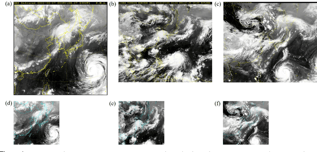
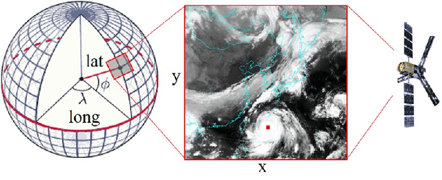
Abstract:Tracks of typhoons are predicted using satellite images as input for a Generative Adversarial Network (GAN). The satellite images have time gaps of 6 hours and are marked with a red square at the location of the typhoon center. The GAN uses images from the past to generate an image one time step ahead. The generated image shows the future location of the typhoon center, as well as the future cloud structures. The errors between predicted and real typhoon centers are measured quantitatively in kilometers. 42.4% of all typhoon center predictions have absolute errors of less than 80 km, 32.1% lie within a range of 80 - 120 km and the remaining 25.5% have accuracies above 120 km. The relative error sets the above mentioned absolute error in relation to the distance that has been traveled by a typhoon over the past 6 hours. High relative errors are found in three types of situations, when a typhoon moves on the open sea far away from land, when a typhoon changes its course suddenly and when a typhoon is about to hit the mainland. The cloud structure prediction is evaluated qualitatively. It is shown that the GAN is able to predict trends in cloud motion. In order to improve both, the typhoon center and cloud motion prediction, the present study suggests to add information about the sea surface temperature, surface pressure and velocity fields to the input data.
 Add to Chrome
 Add to Firefox
 Add to Edge