Manoochehr Shirzaei
A model-based approach for transforming InSAR-derived vertical land motion from a local to a global reference frame
Dec 13, 2024Abstract:Vertical land motion (VLM) observations obtained from Interferometric Synthetic Aperture Radar (InSAR) have transformed our understanding of crustal deformation processes over the past 3 decades. However, these observations are often related to a local reference frame, posing challenges for studies that require large-scale observations within a global reference frame, such as assessments of relative sea level rise and associated hazards. Here, we present a novel approach that enables transforming InSAR-derived VLM at any location worldwide to a global (e.g., International Terrestrial Reference Frame) reference frame without a direct need for GNSS (Global Navigation Satellite System) measurements. To this end, we employ a coarse resolution model of global VLM obtained by interpolating rates of all available GNSS stations over the global land areas. Our rationale is that the high-resolution InSAR-derived VLM data do not capture the long-wavelength signals present in the global VLM model. Therefore, we employ a set of 2D polynomial models to evaluate the difference between InSAR-derived VLM and the global model and then add it back to the InSAR-derived VLM. We examined the validity of our rationale using normalized power spectrum analysis and tested the effect of polynomial order on the accuracy of transformed VLM and the overall success of our approach using two datasets from Los Angeles and New York City. This approach improves the usability of InSAR-derived VLM in geophysical applications, including monitoring regional land subsidence.
Leveraging power of deep learning for fast and efficient elite pixel selection in time series SAR interferometry
Feb 26, 2024


Abstract:This work proposes an improved convolutional long short-term memory (ConvLSTM) based architecture for selection of elite pixels (i.e., less noisy) in time series interferometric synthetic aperture radar (TS-InSAR). Compared to previous version, the model can process InSAR stacks of variable time steps and select both persistent (PS) and distributed scatterers (DS). We trained the model on ~20,000 training images (interferograms), each of size 100 by 100 pixels, extracted from InSAR time series interferograms containing both artificial features (buildings and infrastructure) and objects of natural environment (vegetation, forests, barren or agricultural land, water bodies). Based on such categorization, we developed two deep learning models, primarily focusing on urban and coastal sites. Training labels were generated from elite pixel selection outputs generated from the wavelet-based InSAR (WabInSAR) software developed by Shirzaei (2013) and improved in Lee and Shirzaei (2023). With 4 urban and 7 coastal sites used for training and validation, the predicted elite pixel selection maps reveal that the proposed models efficiently learn from WabInSAR-generated labels, reaching a validation accuracy of 94%. The models accurately discard pixels affected by geometric and temporal decorrelation while selecting pixels corresponding to urban objects and those with stable phase history unaffected by temporal and geometric decorrelation. The density of pixels in urban areas is comparable to and higher for coastal areas compared to WabInSAR outputs. With significantly reduced time computation (order of minutes) and improved selection of elite pixels, the proposed models can efficiently process long InSAR time series stacks and generate rapid deformation maps.
Surface Deformation of New York City from Multitemporal Interferometric Analysis of Sentinel-1 SAR Datasets
Jul 26, 2023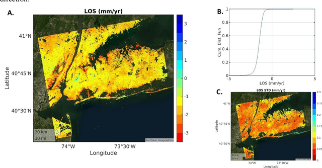
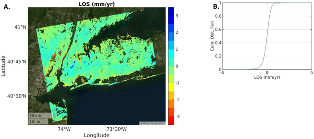
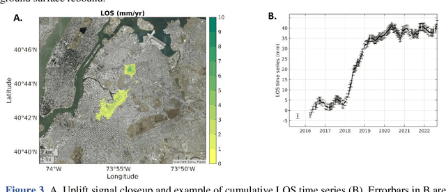
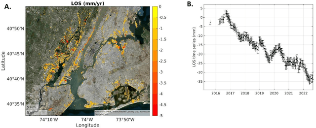
Abstract:Sentinel-1, the Synthetic Aperture Radar (SAR) mission operated by the European Space Agency (ESA) as part of the Copernicus program, provides Free and Open Data with global coverage, transforming our ability to monitor subtle changes in land surface elevation due to natural and anthropogenic process. Here, we use SAR datasets over New York spanning 2015/03/12 to 2022/08/26 and apply an advanced multitemporal SAR interferometric algorithm to measure rates and time series of surface deformation at an unprecedented resolution and accuracy. We found Line-Of-Sight (LOS) subsidence and uplift rates of up to 25.7 -+ 0.2 mm/yr and 8.7 -+ 0.3 mm/yr affecting parts of the city. The LOS velocities, standard deviations, and local incidence angles for ~1,792,000 pixels at ~25m -+ 25 m resolution are provided in an online repository.
A Kalman Filter Framework for Resolving 3D Displacement Field Time Series By Combining Multitrack Multitemporal InSAR and GNSS Horizontal Velocities
Mar 07, 2023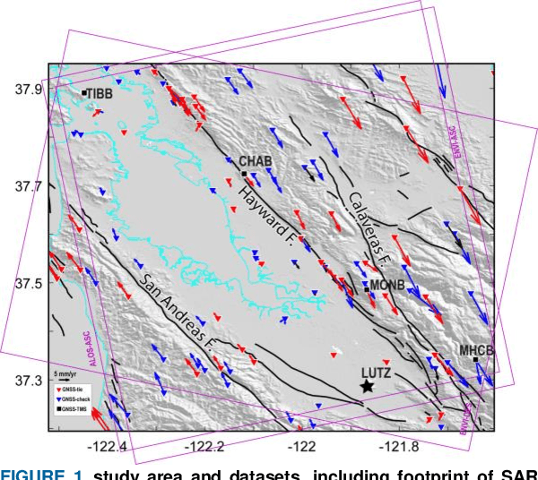
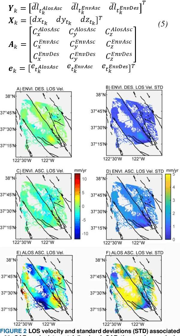
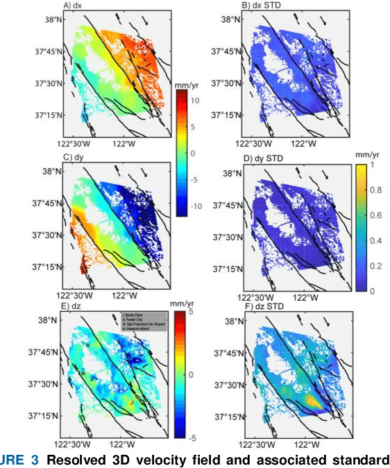
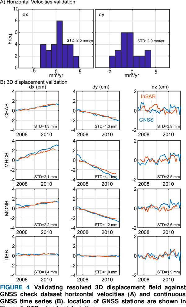
Abstract:The availability of Synthetic Aperture Radar (SAR) data from different sensors and observation of the Global Navigation Satellite System (GNSS) has been growing worldwide. The complementary nature of InSAR and GNSS observations demands methodological advancements for integrating these datasets of variable accuracy, spatiotemporal sampling rate, and geometries to generate seamless maps of 3D time series that account for both observations advantages. Here, I present an approach based on Kalman Filter, which recursively resolves the 3D displacement field time series by combining line-of-sight time series from at least one SAR viewing geometry and horizontal velocities from GNSS networks. I apply this method to 3 overlapping SAR frames in ascending and descending orbits of Envisat C-band and ascending orbit of ALOS L-band acquired over the San Francisco Bay Area from 2007 to 2011. The experimental results and validation tests against independent observations indicate that the presented approach can resolve 3D displacement field time series at mm-level accuracy comparable to GNSS accuracy but at 10s m spatial resolution.
 Add to Chrome
 Add to Firefox
 Add to Edge