Luigi Lombardo
Towards physics-informed neural networks for landslide prediction
Jul 09, 2024Abstract:For decades, solutions to regional scale landslide prediction have mostly relied on data-driven models, by definition, disconnected from the physics of the failure mechanism. The success and spread of such tools came from the ability to exploit proxy variables rather than explicit geotechnical ones, as the latter are prohibitive to acquire over broad landscapes. Our work implements a Physics Informed Neural Network (PINN) approach, thereby adding to a standard data-driven architecture, an intermediate constraint to solve for the permanent deformation typical of Newmark slope stability methods. This translates into a neural network tasked with explicitly retrieving geotechnical parameters from common proxy variables and then minimize a loss function with respect to the available coseismic landside inventory. The results are very promising, because our model not only produces excellent predictive performance in the form of standard susceptibility output, but in the process, also generates maps of the expected geotechnical properties at a regional scale. Such architecture is therefore framed to tackle coseismic landslide prediction, something that, if confirmed in other studies, could open up towards PINN-based near-real-time predictions.
At the junction between deep learning and statistics of extremes: formalizing the landslide hazard definition
Jan 25, 2024


Abstract:The most adopted definition of landslide hazard combines spatial information about landslide location (susceptibility), threat (intensity), and frequency (return period). Only the first two elements are usually considered and estimated when working over vast areas. Even then, separate models constitute the standard, with frequency being rarely investigated. Frequency and intensity are intertwined and depend on each other because larger events occur less frequently and vice versa. However, due to the lack of multi-temporal inventories and joint statistical models, modelling such properties via a unified hazard model has always been challenging and has yet to be attempted. Here, we develop a unified model to estimate landslide hazard at the slope unit level to address such gaps. We employed deep learning, combined with a model motivated by extreme-value theory to analyse an inventory of 30 years of observed rainfall-triggered landslides in Nepal and assess landslide hazard for multiple return periods. We also use our model to further explore landslide hazard for the same return periods under different climate change scenarios up to the end of the century. Our results show that the proposed model performs excellently and can be used to model landslide hazard in a unified manner. Geomorphologically, we find that under both climate change scenarios (SSP245 and SSP885), landslide hazard is likely to increase up to two times on average in the lower Himalayan regions while remaining the same in the middle Himalayan region whilst decreasing slightly in the upper Himalayan region areas.
Deep graphical regression for jointly moderate and extreme Australian wildfires
Aug 28, 2023


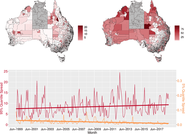
Abstract:Recent wildfires in Australia have led to considerable economic loss and property destruction, and there is increasing concern that climate change may exacerbate their intensity, duration, and frequency. hazard quantification for extreme wildfires is an important component of wildfire management, as it facilitates efficient resource distribution, adverse effect mitigation, and recovery efforts. However, although extreme wildfires are typically the most impactful, both small and moderate fires can still be devastating to local communities and ecosystems. Therefore, it is imperative to develop robust statistical methods to reliably model the full distribution of wildfire spread. We do so for a novel dataset of Australian wildfires from 1999 to 2019, and analyse monthly spread over areas approximately corresponding to Statistical Areas Level 1 and 2 (SA1/SA2) regions. Given the complex nature of wildfire ignition and spread, we exploit recent advances in statistical deep learning and extreme value theory to construct a parametric regression model using graph convolutional neural networks and the extended generalized Pareto distribution, which allows us to model wildfire spread observed on an irregular spatial domain. We highlight the efficacy of our newly proposed model and perform a wildfire hazard assessment for Australia and population-dense communities, namely Tasmania, Sydney, Melbourne, and Perth.
 Add to Chrome
 Add to Firefox
 Add to Edge