Leif Haglund
DisasterInsight: A Multimodal Benchmark for Function-Aware and Grounded Disaster Assessment
Jan 26, 2026Abstract:Timely interpretation of satellite imagery is critical for disaster response, yet existing vision-language benchmarks for remote sensing largely focus on coarse labels and image-level recognition, overlooking the functional understanding and instruction robustness required in real humanitarian workflows. We introduce DisasterInsight, a multimodal benchmark designed to evaluate vision-language models (VLMs) on realistic disaster analysis tasks. DisasterInsight restructures the xBD dataset into approximately 112K building-centered instances and supports instruction-diverse evaluation across multiple tasks, including building-function classification, damage-level and disaster-type classification, counting, and structured report generation aligned with humanitarian assessment guidelines. To establish domain-adapted baselines, we propose DI-Chat, obtained by fine-tuning existing VLM backbones on disaster-specific instruction data using parameter-efficient Low-Rank Adaptation (LoRA). Extensive experiments on state-of-the-art generic and remote-sensing VLMs reveal substantial performance gaps across tasks, particularly in damage understanding and structured report generation. DI-Chat achieves significant improvements on damage-level and disaster-type classification as well as report generation quality, while building-function classification remains challenging for all evaluated models. DisasterInsight provides a unified benchmark for studying grounded multimodal reasoning in disaster imagery.
Comparing Satellite Data for Next-Day Wildfire Predictability
Mar 11, 2025Abstract:Multiple studies have performed next-day fire prediction using satellite imagery. Two main satellites are used to detect wildfires: MODIS and VIIRS. Both satellites provide fire mask products, called MOD14 and VNP14, respectively. Studies have used one or the other, but there has been no comparison between them to determine which might be more suitable for next-day fire prediction. In this paper, we first evaluate how well VIIRS and MODIS data can be used to forecast wildfire spread one day ahead. We find that the model using VIIRS as input and VNP14 as target achieves the best results. Interestingly, the model using MODIS as input and VNP14 as target performs significantly better than using VNP14 as input and MOD14 as target. Next, we discuss why MOD14 might be harder to use for predicting next-day fires. We find that the MOD14 fire mask is highly stochastic and does not correlate with reasonable fire spread patterns. This is detrimental for machine learning tasks, as the model learns irrational patterns. Therefore, we conclude that MOD14 is unsuitable for next-day fire prediction and that VNP14 is a much better option. However, using MODIS input and VNP14 as target, we achieve a significant improvement in predictability. This indicates that an improved fire detection model is possible for MODIS. The full code and dataset is available online: https://github.com/justuskarlsson/wildfire-mod14-vnp14
Exploring Seasonal Variability in the Context of Neural Radiance Fields for 3D Reconstruction on Satellite Imagery
Nov 05, 2024


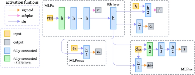
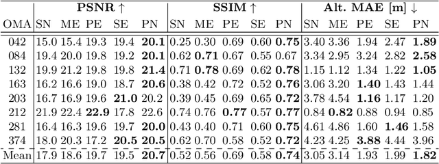
Abstract:In this work, the seasonal predictive capabilities of Neural Radiance Fields (NeRF) applied to satellite images are investigated. Focusing on the utilization of satellite data, the study explores how Sat-NeRF, a novel approach in computer vision, performs in predicting seasonal variations across different months. Through comprehensive analysis and visualization, the study examines the model's ability to capture and predict seasonal changes, highlighting specific challenges and strengths. Results showcase the impact of the sun direction on predictions, revealing nuanced details in seasonal transitions, such as snow cover, color accuracy, and texture representation in different landscapes. Given these results, we propose Planet-NeRF, an extension to Sat-NeRF capable of incorporating seasonal variability through a set of month embedding vectors. Comparative evaluations reveal that Planet-NeRF outperforms prior models in the case where seasonal changes are present. The extensive evaluation combined with the proposed method offers promising avenues for future research in this domain.
Sen2Fire: A Challenging Benchmark Dataset for Wildfire Detection using Sentinel Data
Mar 26, 2024Abstract:Utilizing satellite imagery for wildfire detection presents substantial potential for practical applications. To advance the development of machine learning algorithms in this domain, our study introduces the \textit{Sen2Fire} dataset--a challenging satellite remote sensing dataset tailored for wildfire detection. This dataset is curated from Sentinel-2 multi-spectral data and Sentinel-5P aerosol product, comprising a total of 2466 image patches. Each patch has a size of 512$\times$512 pixels with 13 bands. Given the distinctive sensitivities of various wavebands to wildfire responses, our research focuses on optimizing wildfire detection by evaluating different wavebands and employing a combination of spectral indices, such as normalized burn ratio (NBR) and normalized difference vegetation index (NDVI). The results suggest that, in contrast to using all bands for wildfire detection, selecting specific band combinations yields superior performance. Additionally, our study underscores the positive impact of integrating Sentinel-5 aerosol data for wildfire detection. The code and dataset are available online (https://zenodo.org/records/10881058).
 Add to Chrome
 Add to Firefox
 Add to Edge