Jaime Carrasco
Advancing Forest Fire Prevention: Deep Reinforcement Learning for Effective Firebreak Placement
Apr 12, 2024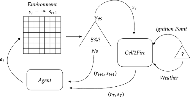
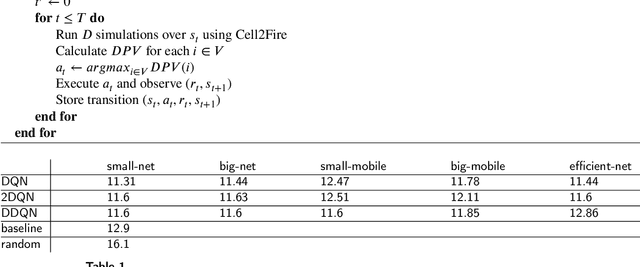
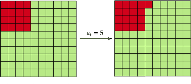

Abstract:Over the past decades, the increase in both frequency and intensity of large-scale wildfires due to climate change has emerged as a significant natural threat. The pressing need to design resilient landscapes capable of withstanding such disasters has become paramount, requiring the development of advanced decision-support tools. Existing methodologies, including Mixed Integer Programming, Stochastic Optimization, and Network Theory, have proven effective but are hindered by computational demands, limiting their applicability. In response to this challenge, we propose using artificial intelligence techniques, specifically Deep Reinforcement Learning, to address the complex problem of firebreak placement in the landscape. We employ value-function based approaches like Deep Q-Learning, Double Deep Q-Learning, and Dueling Double Deep Q-Learning. Utilizing the Cell2Fire fire spread simulator combined with Convolutional Neural Networks, we have successfully implemented a computational agent capable of learning firebreak locations within a forest environment, achieving good results. Furthermore, we incorporate a pre-training loop, initially teaching our agent to mimic a heuristic-based algorithm and observe that it consistently exceeds the performance of these solutions. Our findings underscore the immense potential of Deep Reinforcement Learning for operational research challenges, especially in fire prevention. Our approach demonstrates convergence with highly favorable results in problem instances as large as 40 x 40 cells, marking a significant milestone in applying Reinforcement Learning to this critical issue. To the best of our knowledge, this study represents a pioneering effort in using Reinforcement Learning to address the aforementioned problem, offering promising perspectives in fire prevention and landscape management
Comparison of metaheuristics for the firebreak placement problem: a simulation-based optimization approach
Nov 29, 2023Abstract:The problem of firebreak placement is crucial for fire prevention, and its effectiveness at landscape scale will depend on their ability to impede the progress of future wildfires. To provide an adequate response, it is therefore necessary to consider the stochastic nature of fires, which are highly unpredictable from ignition to extinction. Thus, the placement of firebreaks can be considered a stochastic optimization problem where: (1) the objective function is to minimize the expected cells burnt of the landscape; (2) the decision variables being the location of firebreaks; and (3) the random variable being the spatial propagation/behavior of fires. In this paper, we propose a solution approach for the problem from the perspective of simulation-based optimization (SbO), where the objective function is not available (a black-box function), but can be computed (and/or approximated) by wildfire simulations. For this purpose, Genetic Algorithm and GRASP are implemented. The final implementation yielded favorable results for the Genetic Algorithm, demonstrating strong performance in scenarios with medium to high operational capacity, as well as medium levels of stochasticity
Two Scalable Approaches for Burned-Area Mapping Using U-Net and Landsat Imagery
Nov 29, 2023


Abstract:Monitoring wildfires is an essential step in minimizing their impact on the planet, understanding the many negative environmental, economic, and social consequences. Recent advances in remote sensing technology combined with the increasing application of artificial intelligence methods have improved real-time, high-resolution fire monitoring. This study explores two proposed approaches based on the U-Net model for automating and optimizing the burned-area mapping process. Denoted 128 and AllSizes (AS), they are trained on datasets with a different class balance by cropping input images to different sizes. They are then applied to Landsat imagery and time-series data from two fire-prone regions in Chile. The results obtained after enhancement of model performance by hyperparameter optimization demonstrate the effectiveness of both approaches. Tests based on 195 representative images of the study area show that increasing dataset balance using the AS model yields better performance. More specifically, AS exhibited a Dice Coefficient (DC) of 0.93, an Omission Error (OE) of 0.086, and a Commission Error (CE) of 0.045, while the 128 model achieved a DC of 0.86, an OE of 0.12, and a CE of 0.12. These findings should provide a basis for further development of scalable automatic burned-area mapping tools.
Adjusting Rate of Spread Factors through Derivative-Free Optimization: A New Methodology to Improve the Performance of Forest Fire Simulators
Sep 11, 2019
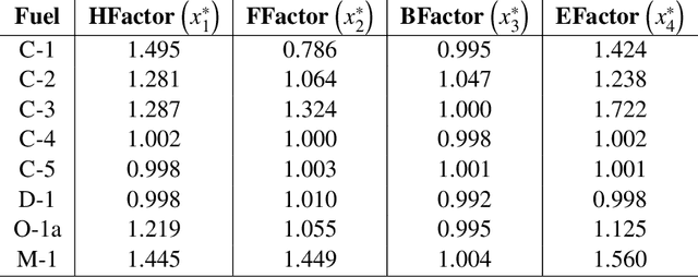

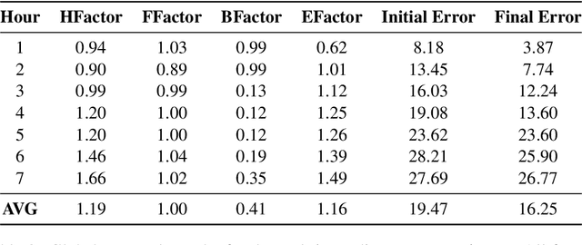
Abstract:In practical applications, it is common that wildfire simulators do not correctly predict the evolution of the fire scar. Usually, this is caused due to multiple factors including inaccuracy in the input data such as land cover classification, moisture, improperly represented local winds, cumulative errors in the fire growth simulation model, high level of discontinuity/heterogeneity within the landscape, among many others. Therefore in practice, it is necessary to adjust the propagation of the fire to obtain better results, either to support suppression activities or to improve the performance of the simulator considering new default parameters for future events, best representing the current fire spread growth phenomenon. In this article, we address this problem through a new methodology using Derivative-Free Optimization (DFO) algorithms for adjusting the Rate of Spread (ROS) factors in a fire simulation growth model called Cell2Fire. To achieve this, we solve an error minimization optimization problem that captures the difference between the simulated and observed fire, which involves the evaluation of the simulator output in each iteration as part of a DFO framework, allowing us to find the best possible factors for each fuel present on the landscape. Numerical results for different objective functions are shown and discussed, including a performance comparison of alternative DFO algorithms.
 Add to Chrome
 Add to Firefox
 Add to Edge