Isabelle Tingzon
Large-scale School Mapping using Weakly Supervised Deep Learning for Universal School Connectivity
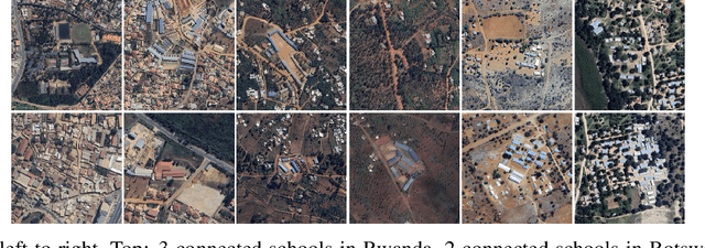
Dec 19, 2024Abstract:Improving global school connectivity is critical for ensuring inclusive and equitable quality education. To reliably estimate the cost of connecting schools, governments and connectivity providers require complete and accurate school location data - a resource that is often scarce in many low- and middle-income countries. To address this challenge, we propose a cost-effective, scalable approach to locating schools in high-resolution satellite images using weakly supervised deep learning techniques. Our best models, which combine vision transformers and convolutional neural networks, achieve AUPRC values above 0.96 across 10 pilot African countries. Leveraging explainable AI techniques, our approach can approximate the precise geographical coordinates of the school locations using only low-cost, classification-level annotations. To demonstrate the scalability of our method, we generate nationwide maps of school location predictions in African countries and present a detailed analysis of our results, using Senegal as our case study. Finally, we demonstrate the immediate usability of our work by introducing an interactive web mapping tool to streamline human-in-the-loop model validation efforts by government partners. This work successfully showcases the real-world utility of deep learning and satellite images for planning regional infrastructure and accelerating universal school connectivity.
Predicting Internet Connectivity in Schools: A Feasibility Study Leveraging Multi-modal Data and Location Encoders in Low-Resource Settings
Dec 13, 2024


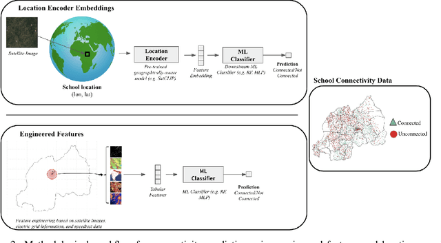
Abstract:Internet connectivity in schools is critical to provide students with the digital literary skills necessary to compete in modern economies. In order for governments to effectively implement digital infrastructure development in schools, accurate internet connectivity information is required. However, traditional survey-based methods can exceed the financial and capacity limits of governments. Open-source Earth Observation (EO) datasets have unlocked our ability to observe and understand socio-economic conditions on Earth from space, and in combination with Machine Learning (ML), can provide the tools to circumvent costly ground-based survey methods to support infrastructure development. In this paper, we present our work on school internet connectivity prediction using EO and ML. We detail the creation of our multi-modal, freely-available satellite imagery and survey information dataset, leverage the latest geographically-aware location encoders, and introduce the first results of using the new European Space Agency phi-lab geographically-aware foundational model to predict internet connectivity in Botswana and Rwanda. We find that ML with EO and ground-based auxiliary data yields the best performance in both countries, for accuracy, F1 score, and False Positive rates, and highlight the challenges of internet connectivity prediction from space with a case study in Kigali, Rwanda. Our work showcases a practical approach to support data-driven digital infrastructure development in low-resource settings, leveraging freely available information, and provide cleaned and labelled datasets for future studies to the community through a unique collaboration between UNICEF and the European Space Agency phi-lab.
Mapping Housing Stock Characteristics from Drone Images for Climate Resilience in the Caribbean
Dec 16, 2023Abstract:Comprehensive information on housing stock is crucial for climate adaptation initiatives aiming to reduce the adverse impacts of climate-extreme hazards in high-risk regions like the Caribbean. In this study, we propose a workflow for rapidly generating critical baseline housing stock data using very high-resolution drone images and deep learning techniques. Specifically, our work leverages the Segment Anything Model and convolutional neural networks for the automated generation of building footprints and roof classification maps. By strengthening local capacity within government agencies to leverage AI and Earth Observation-based solutions, this work seeks to improve the climate resilience of the housing sector in small island developing states in the Caribbean.
Fusing VHR Post-disaster Aerial Imagery and LiDAR Data for Roof Classification in the Caribbean
Aug 20, 2023Abstract:Accurate and up-to-date information on building characteristics is essential for vulnerability assessment; however, the high costs and long timeframes associated with conducting traditional field surveys can be an obstacle to obtaining critical exposure datasets needed for disaster risk management. In this work, we leverage deep learning techniques for the automated classification of roof characteristics from very high-resolution orthophotos and airborne LiDAR data obtained in Dominica following Hurricane Maria in 2017. We demonstrate that the fusion of multimodal earth observation data performs better than using any single data source alone. Using our proposed methods, we achieve F1 scores of 0.93 and 0.92 for roof type and roof material classification, respectively. This work is intended to help governments produce more timely building information to improve resilience and disaster response in the Caribbean.
 Add to Chrome
 Add to Firefox
 Add to Edge