Carlos Miravet
SENER, Madrid, Spain
A PCA-Based Super-Resolution Algorithm for Short Image Sequences
Jan 18, 2012


Abstract:In this paper, we present a novel, learning-based, two-step super-resolution (SR) algorithm well suited to solve the specially demanding problem of obtaining SR estimates from short image sequences. The first step, devoted to increase the sampling rate of the incoming images, is performed by fitting linear combinations of functions generated from principal components (PC) to reproduce locally the sparse projected image data, and using these models to estimate image values at nodes of the high-resolution grid. PCs were obtained from local image patches sampled at sub-pixel level, which were generated in turn from a database of high-resolution images by application of a physically realistic observation model. Continuity between local image models is enforced by minimizing an adequate functional in the space of model coefficients. The second step, dealing with restoration, is performed by a linear filter with coefficients learned to restore residual interpolation artifacts in addition to low-resolution blurring, providing an effective coupling between both steps of the method. Results on a demanding five-image scanned sequence of graphics and text are presented, showing the excellent performance of the proposed method compared to several state-of-the-art two-step and Bayesian Maximum a Posteriori SR algorithms.
An Image-Based Sensor System for Autonomous Rendez-Vous with Uncooperative Satellites
Jul 28, 2008


Abstract:In this paper are described the image processing algorithms developed by SENER, Ingenieria y Sistemas to cope with the problem of image-based, autonomous rendez-vous (RV) with an orbiting satellite. The methods developed have a direct application in the OLEV (Orbital Life Extension Extension Vehicle) mission. OLEV is a commercial mission under development by a consortium formed by Swedish Space Corporation, Kayser-Threde and SENER, aimed to extend the operational life of geostationary telecommunication satellites by supplying them control, navigation and guidance services. OLEV is planned to use a set of cameras to determine the angular position and distance to the client satellite during the complete phases of rendez-vous and docking, thus enabling the operation with satellites not equipped with any specific navigational aid to provide support during the approach. The ability to operate with un-equipped client satellites significantly expands the range of applicability of the system under development, compared to other competing video technologies already tested in previous spatial missions, such as the ones described here below.
A decision support system for ship identification based on the curvature scale space representation
Oct 11, 2005Abstract:In this paper, a decision support system for ship identification is presented. The system receives as input a silhouette of the vessel to be identified, previously extracted from a side view of the object. This view could have been acquired with imaging sensors operating at different spectral ranges (CCD, FLIR, image intensifier). The input silhouette is preprocessed and compared to those stored in a database, retrieving a small number of potential matches ranked by their similarity to the target silhouette. This set of potential matches is presented to the system operator, who makes the final ship identification. This system makes use of an evolved version of the Curvature Scale Space (CSS) representation. In the proposed approach, it is curvature extrema, instead of zero crossings, that are tracked during silhouette evolution, hence improving robustness and enabling to cope successfully with cases where the standard CCS representation is found to be unstable. Also, the use of local curvature was replaced with the more robust concept of lobe concavity, with significant additional gains in performance. Experimental results on actual operational imagery prove the excellent performance and robustness of the developed method.
Accurate and robust image superresolution by neural processing of local image representations
Oct 03, 2005


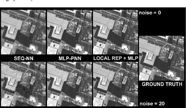
Abstract:Image superresolution involves the processing of an image sequence to generate a still image with higher resolution. Classical approaches, such as bayesian MAP methods, require iterative minimization procedures, with high computational costs. Recently, the authors proposed a method to tackle this problem, based on the use of a hybrid MLP-PNN architecture. In this paper, we present a novel superresolution method, based on an evolution of this concept, to incorporate the use of local image models. A neural processing stage receives as input the value of model coefficients on local windows. The data dimensionality is firstly reduced by application of PCA. An MLP, trained on synthetic sequences with various amounts of noise, estimates the high-resolution image data. The effect of varying the dimension of the network input space is examined, showing a complex, structured behavior. Quantitative results are presented showing the accuracy and robustness of the proposed method.
* 6 pages with 3 figures. ICANN 2005
Semi-automatic vectorization of linear networks on rasterized cartographic maps
Mar 22, 2005Abstract:A system for semi-automatic vectorization of linear networks (roads, rivers, etc.) on rasterized cartographic maps is presented. In this system, human intervention is limited to a graphic, interactive selection of the color attributes of the information to be obtained. Using this data, the system performs a preliminary extraction of the linear network, which is subsequently completed, refined and vectorized by means of an automatic procedure. Results on maps of different sources and scales are included. ----- Se presenta un sistema semi-automatico de vectorizacion de redes de objetos lineales (carreteras, rios, etc.) en mapas cartograficos digitalizados. En este sistema, la intervencion humana queda reducida a la seleccion grafica interactiva de los atributos de color de la informacion a obtener. Con estos datos, el sistema realiza una extraccion preliminar de la red lineal, que se completa, refina y vectoriza mediante un procedimiento automatico. Se presentan resultados de la aplicacion del sistema sobre imagenes digitalizadas de mapas de distinta procedencia y escala.
* 12 pages with 13 figures, in Spanish
A hybrid MLP-PNN architecture for fast image superresolution
Mar 22, 2005


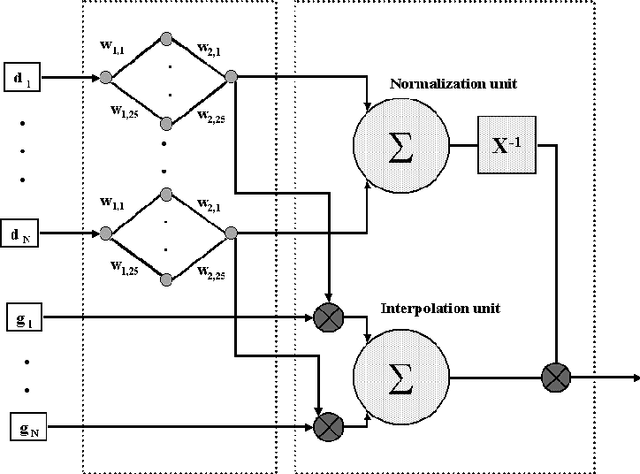
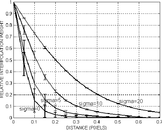
Abstract:Image superresolution methods process an input image sequence of a scene to obtain a still image with increased resolution. Classical approaches to this problem involve complex iterative minimization procedures, typically with high computational costs. In this paper is proposed a novel algorithm for super-resolution that enables a substantial decrease in computer load. First, a probabilistic neural network architecture is used to perform a scattered-point interpolation of the image sequence data. The network kernel function is optimally determined for this problem by a multi-layer perceptron trained on synthetic data. Network parameters dependence on sequence noise level is quantitatively analyzed. This super-sampled image is spatially filtered to correct finite pixel size effects, to yield the final high-resolution estimate. Results on a real outdoor sequence are presented, showing the quality of the proposed method.
* 8 pages with 4 figures. ICANN/ICONIP 2003
 Add to Chrome
 Add to Firefox
 Add to Edge