Antonios Makris
FedGreed: A Byzantine-Robust Loss-Based Aggregation Method for Federated Learning
Aug 25, 2025Abstract:Federated Learning (FL) enables collaborative model training across multiple clients while preserving data privacy by keeping local datasets on-device. In this work, we address FL settings where clients may behave adversarially, exhibiting Byzantine attacks, while the central server is trusted and equipped with a reference dataset. We propose FedGreed, a resilient aggregation strategy for federated learning that does not require any assumptions about the fraction of adversarial participants. FedGreed orders clients' local model updates based on their loss metrics evaluated against a trusted dataset on the server and greedily selects a subset of clients whose models exhibit the minimal evaluation loss. Unlike many existing approaches, our method is designed to operate reliably under heterogeneous (non-IID) data distributions, which are prevalent in real-world deployments. FedGreed exhibits convergence guarantees and bounded optimality gaps under strong adversarial behavior. Experimental evaluations on MNIST, FMNIST, and CIFAR-10 demonstrate that our method significantly outperforms standard and robust federated learning baselines, such as Mean, Trimmed Mean, Median, Krum, and Multi-Krum, in the majority of adversarial scenarios considered, including label flipping and Gaussian noise injection attacks. All experiments were conducted using the Flower federated learning framework.
Robust Federated Learning under Adversarial Attacks via Loss-Based Client Clustering
Aug 18, 2025Abstract:Federated Learning (FL) enables collaborative model training across multiple clients without sharing private data. We consider FL scenarios wherein FL clients are subject to adversarial (Byzantine) attacks, while the FL server is trusted (honest) and has a trustworthy side dataset. This may correspond to, e.g., cases where the server possesses trusted data prior to federation, or to the presence of a trusted client that temporarily assumes the server role. Our approach requires only two honest participants, i.e., the server and one client, to function effectively, without prior knowledge of the number of malicious clients. Theoretical analysis demonstrates bounded optimality gaps even under strong Byzantine attacks. Experimental results show that our algorithm significantly outperforms standard and robust FL baselines such as Mean, Trimmed Mean, Median, Krum, and Multi-Krum under various attack strategies including label flipping, sign flipping, and Gaussian noise addition across MNIST, FMNIST, and CIFAR-10 benchmarks using the Flower framework.
WEST GCN-LSTM: Weighted Stacked Spatio-Temporal Graph Neural Networks for Regional Traffic Forecasting
May 01, 2024
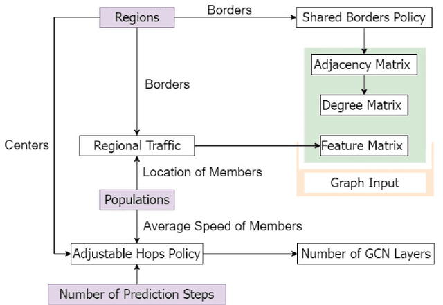
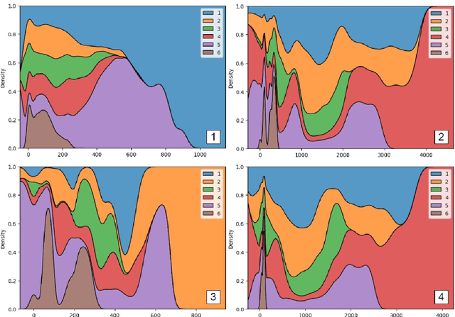
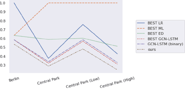
Abstract:Regional traffic forecasting is a critical challenge in urban mobility, with applications to various fields such as the Internet of Everything. In recent years, spatio-temporal graph neural networks have achieved state-of-the-art results in the context of numerous traffic forecasting challenges. This work aims at expanding upon the conventional spatio-temporal graph neural network architectures in a manner that may facilitate the inclusion of information regarding the examined regions, as well as the populations that traverse them, in order to establish a more efficient prediction model. The end-product of this scientific endeavour is a novel spatio-temporal graph neural network architecture that is referred to as WEST (WEighted STacked) GCN-LSTM. Furthermore, the inclusion of the aforementioned information is conducted via the use of two novel dedicated algorithms that are referred to as the Shared Borders Policy and the Adjustable Hops Policy. Through information fusion and distillation, the proposed solution manages to significantly outperform its competitors in the frame of an experimental evaluation that consists of 19 forecasting models, across several datasets. Finally, an additional ablation study determined that each of the components of the proposed solution contributes towards enhancing its overall performance.
An evaluation of time series forecasting models on water consumption data: A case study of Greece
Mar 30, 2023


Abstract:In recent years, the increased urbanization and industrialization has led to a rising water demand and resources, thus increasing the gap between demand and supply. Proper water distribution and forecasting of water consumption are key factors in mitigating the imbalance of supply and demand by improving operations, planning and management of water resources. To this end, in this paper, several well-known forecasting algorithms are evaluated over time series, water consumption data from Greece, a country with diverse socio-economic and urbanization issues. The forecasting algorithms are evaluated on a real-world dataset provided by the Water Supply and Sewerage Company of Greece revealing key insights about each algorithm and its use.
TraClets: Harnessing the power of computer vision for trajectory classification
May 30, 2022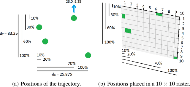
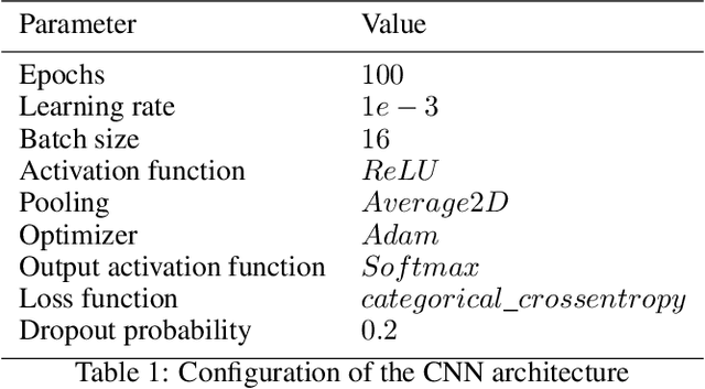
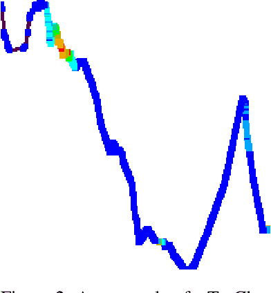

Abstract:Due to the advent of new mobile devices and tracking sensors in recent years, huge amounts of data are being produced every day. Therefore, novel methodologies need to emerge that dive through this vast sea of information and generate insights and meaningful information. To this end, researchers have developed several trajectory classification algorithms over the years that are able to annotate tracking data. Similarly, in this research, a novel methodology is presented that exploits image representations of trajectories, called TraClets, in order to classify trajectories in an intuitive humans way, through computer vision techniques. Several real-world datasets are used to evaluate the proposed approach and compare its classification performance to other state-of-the-art trajectory classification algorithms. Experimental results demonstrate that TraClets achieves a classification performance that is comparable to, or in most cases, better than the state-of-the-art, acting as a universal, high-accuracy approach for trajectory classification.
 Add to Chrome
 Add to Firefox
 Add to Edge