Ahmad Gholizadeh Lonbar
Comparative Analysis of Segment Anything Model and U-Net for Breast Tumor Detection in Ultrasound and Mammography Images
Jun 21, 2023


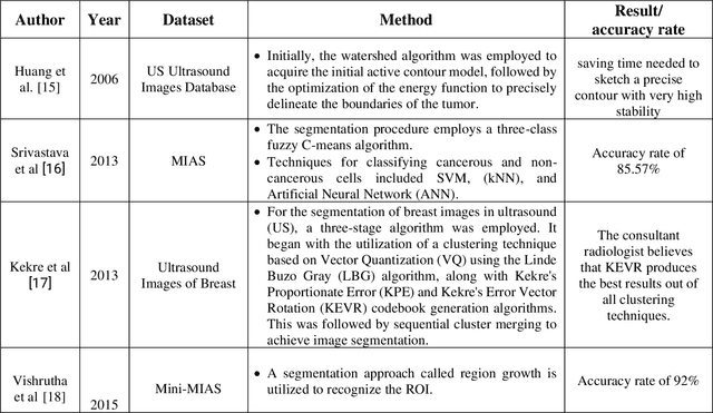
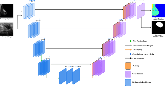
Abstract:In this study, the main objective is to develop an algorithm capable of identifying and delineating tumor regions in breast ultrasound (BUS) and mammographic images. The technique employs two advanced deep learning architectures, namely U-Net and pretrained SAM, for tumor segmentation. The U-Net model is specifically designed for medical image segmentation and leverages its deep convolutional neural network framework to extract meaningful features from input images. On the other hand, the pretrained SAM architecture incorporates a mechanism to capture spatial dependencies and generate segmentation results. Evaluation is conducted on a diverse dataset containing annotated tumor regions in BUS and mammographic images, covering both benign and malignant tumors. This dataset enables a comprehensive assessment of the algorithm's performance across different tumor types. Results demonstrate that the U-Net model outperforms the pretrained SAM architecture in accurately identifying and segmenting tumor regions in both BUS and mammographic images. The U-Net exhibits superior performance in challenging cases involving irregular shapes, indistinct boundaries, and high tumor heterogeneity. In contrast, the pretrained SAM architecture exhibits limitations in accurately identifying tumor areas, particularly for malignant tumors and objects with weak boundaries or complex shapes. These findings highlight the importance of selecting appropriate deep learning architectures tailored for medical image segmentation. The U-Net model showcases its potential as a robust and accurate tool for tumor detection, while the pretrained SAM architecture suggests the need for further improvements to enhance segmentation performance.
Supervised Multi-Regional Segmentation Machine Learning Architecture for Digital Twin Applications in Coastal Regions
May 23, 2023


Abstract:This study explores the use of a digital twin model and deep learning method to build a global terrain and altitude map based on USGS information. The goal is to artistically represent various landforms while incorporating precise elevation modifications in the terrain map and encoding land height in the altitude map. A random selection of 5000 segments from the worldwide map guarantees the inclusion of significant characteristics in the subsets, with rescaling according to latitude accounting for distortions caused by map projection. The process of generating segmentation maps involves using unsupervised clustering and classification methods, segmenting the terrain into seven groups: Water, Grassland, Forest, Hills, Desert, Mountain, and Tundra. Each group is assigned a unique color, and median filtering is used to improve map characteristics. Random parameters are added to provide diversity and avoid duplication in overlapping image sets. The U-Net network is deployed for the segmentation task, with training conducted on the seven terrain classes. Cross-validation is carried out every 10 epochs to gauge the model's performance. The segmentation maps produced accurately categorize the terrain, as evidenced by the ROC curve and AUC values. The main goal of this research is to create a digital twin model of Florida's coastal area. This is achieved through the application of deep learning methods and satellite imagery from Google Earth, resulting in a detailed depiction of the coast of Florida. The digital twin acts as both a physical and a simulation model of the area, emphasizing its capability to capture and replicate real-world locations. The model effectively creates a global terrain and altitude map with precise segmentation and capture of important land features. The results confirm the effectiveness of the digital twin, especially in depicting Florida's coastline.
Application of Segment Anything Model for Civil Infrastructure Defect Assessment
Apr 25, 2023


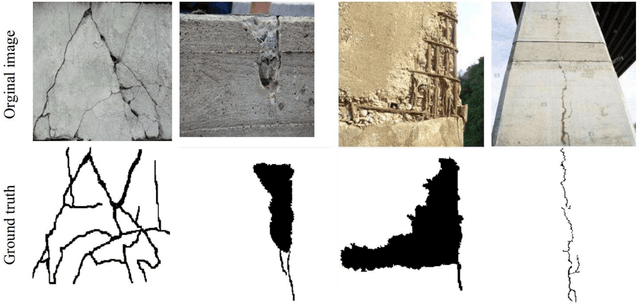
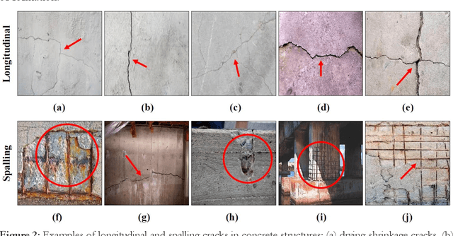
Abstract:This research assesses the performance of two deep learning models, SAM and U-Net, for detecting cracks in concrete structures. The results indicate that each model has its own strengths and limitations for detecting different types of cracks. Using the SAM's unique crack detection approach, the image is divided into various parts that identify the location of the crack, making it more effective at detecting longitudinal cracks. On the other hand, the U-Net model can identify positive label pixels to accurately detect the size and location of spalling cracks. By combining both models, more accurate and comprehensive crack detection results can be achieved. The importance of using advanced technologies for crack detection in ensuring the safety and longevity of concrete structures cannot be overstated. This research can have significant implications for civil engineering, as the SAM and U-Net model can be used for a variety of concrete structures, including bridges, buildings, and roads, improving the accuracy and efficiency of crack detection and saving time and resources in maintenance and repair. In conclusion, the SAM and U-Net model presented in this study offer promising solutions for detecting cracks in concrete structures and leveraging the strengths of both models that can lead to more accurate and comprehensive results.
 Add to Chrome
 Add to Firefox
 Add to Edge