 Add to Chrome
 Add to Firefox
 Add to Edge
Utilizing geospatial data for assessing energy security: Mapping small solar home systems using unmanned aerial vehicles and deep learning
Paper and Code
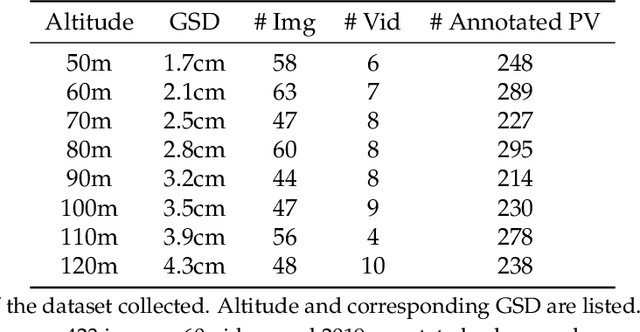
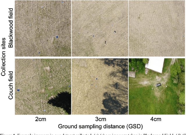
Solar home systems (SHS), a cost-effective solution for rural communities far from the grid in developing countries, are small solar panels and associated equipment that provides power to a single household. A crucial resource for targeting further investment of public and private resources, as well as tracking the progress of universal electrification goals, is shared access to high-quality data on individual SHS installations including information such as location and power capacity. Though recent studies utilizing satellite imagery and machine learning to detect solar panels have emerged, they struggle to accurately locate many SHS due to limited image resolution (some small solar panels only occupy several pixels in satellite imagery). In this work, we explore the viability and cost-performance tradeoff of using automatic SHS detection on unmanned aerial vehicle (UAV) imagery as an alternative to satellite imagery. More specifically, we explore three questions: (i) what is the detection performance of SHS using drone imagery; (ii) how expensive is the drone data collection, compared to satellite imagery; and (iii) how well does drone-based SHS detection perform in real-world scenarios. We collect and publicly-release a dataset of high-resolution drone imagery encompassing SHS imaged under real-world conditions and use this dataset and a dataset from Rwanda to evaluate the capabilities of deep learning models to recognize SHS, including those that are too small to be reliably recognized in satellite imagery. The results suggest that UAV imagery may be a viable alternative to identify very small SHS from perspectives of both detection accuracy and financial costs of data collection. UAV-based data collection may be a practical option for supporting electricity access planning strategies for achieving sustainable development goals and for monitoring the progress towards those goals.