A Spacecraft Dataset for Detection, Segmentation and Parts Recognition
Paper and Code
Jun 15, 2021


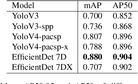
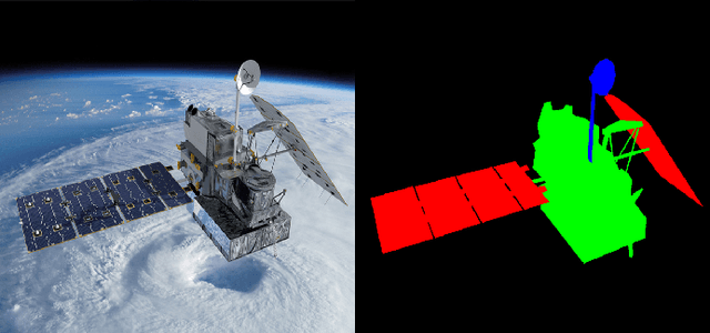
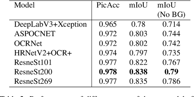
Virtually all aspects of modern life depend on space technology. Thanks to the great advancement of computer vision in general and deep learning-based techniques in particular, over the decades, the world witnessed the growing use of deep learning in solving problems for space applications, such as self-driving robot, tracers, insect-like robot on cosmos and health monitoring of spacecraft. These are just some prominent examples that has advanced space industry with the help of deep learning. However, the success of deep learning models requires a lot of training data in order to have decent performance, while on the other hand, there are very limited amount of publicly available space datasets for the training of deep learning models. Currently, there is no public datasets for space-based object detection or instance segmentation, partly because manually annotating object segmentation masks is very time consuming as they require pixel-level labelling, not to mention the challenge of obtaining images from space. In this paper, we aim to fill this gap by releasing a dataset for spacecraft detection, instance segmentation and part recognition. The main contribution of this work is the development of the dataset using images of space stations and satellites, with rich annotations including bounding boxes of spacecrafts and masks to the level of object parts, which are obtained with a mixture of automatic processes and manual efforts. We also provide evaluations with state-of-the-art methods in object detection and instance segmentation as a benchmark for the dataset. The link for downloading the proposed dataset can be found on https://github.com/Yurushia1998/SatelliteDataset.
 Add to Chrome
 Add to Firefox
 Add to Edge