Youngjun Choe
Open-source data pipeline for street-view images: a case study on community mobility during COVID-19 pandemic
Jan 23, 2024


Abstract:Street View Images (SVI) are a common source of valuable data for researchers. Researchers have used SVI data for estimating pedestrian volumes, demographic surveillance, and to better understand built and natural environments in cityscapes. However, the most common source of publicly available SVI data is Google Street View. Google Street View images are collected infrequently, making temporal analysis challenging, especially in low population density areas. Our main contribution is the development of an open-source data pipeline for processing 360-degree video recorded from a car-mounted camera. The video data is used to generate SVIs, which then can be used as an input for temporal analysis. We demonstrate the use of the pipeline by collecting a SVI dataset over a 38-month longitudinal survey of Seattle, WA, USA during the COVID-19 pandemic. The output of our pipeline is validated through statistical analyses of pedestrian traffic in the images. We confirm known results in the literature and provide new insights into outdoor pedestrian traffic patterns. This study demonstrates the feasibility and value of collecting and using SVI for research purposes beyond what is possible with currently available SVI data. Limitations and future improvements on the data pipeline and case study are also discussed.
Post-Hurricane Damage Assessment Using Satellite Imagery and Geolocation Features
Dec 15, 2020


Abstract:Gaining timely and reliable situation awareness after hazard events such as a hurricane is crucial to emergency managers and first responders. One effective way to achieve that goal is through damage assessment. Recently, disaster researchers have been utilizing imagery captured through satellites or drones to quantify the number of flooded/damaged buildings. In this paper, we propose a mixed data approach, which leverages publicly available satellite imagery and geolocation features of the affected area to identify damaged buildings after a hurricane. The method demonstrated significant improvement from performing a similar task using only imagery features, based on a case study of Hurricane Harvey affecting Greater Houston area in 2017. This result opens door to a wide range of possibilities to unify the advancement in computer vision algorithms such as convolutional neural networks and traditional methods in damage assessment, for example, using flood depth or bare-earth topology. In this work, a creative choice of the geolocation features was made to provide extra information to the imagery features, but it is up to the users to decide which other features can be included to model the physical behavior of the events, depending on their domain knowledge and the type of disaster. The dataset curated in this work is made openly available (DOI: 10.17603/ds2-3cca-f398).
Splitting Gaussian Process Regression for Streaming Data
Oct 06, 2020


Abstract:Gaussian processes offer a flexible kernel method for regression. While Gaussian processes have many useful theoretical properties and have proven practically useful, they suffer from poor scaling in the number of observations. In particular, the cubic time complexity of updating standard Gaussian process models make them generally unsuitable for application to streaming data. We propose an algorithm for sequentially partitioning the input space and fitting a localized Gaussian process to each disjoint region. The algorithm is shown to have superior time and space complexity to existing methods, and its sequential nature permits application to streaming data. The algorithm constructs a model for which the time complexity of updating is tightly bounded above by a pre-specified parameter. To the best of our knowledge, the model is the first local Gaussian process regression model to achieve linear memory complexity. Theoretical continuity properties of the model are proven. We demonstrate the efficacy of the resulting model on multi-dimensional regression tasks for streaming data.
Benchmark Dataset for Automatic Damaged Building Detection from Post-Hurricane Remotely Sensed Imagery
Dec 13, 2018


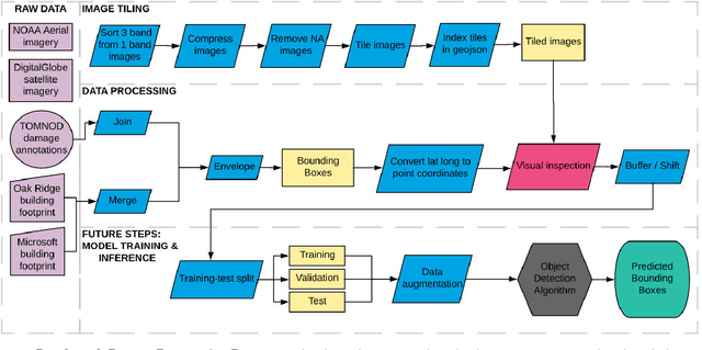
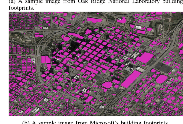
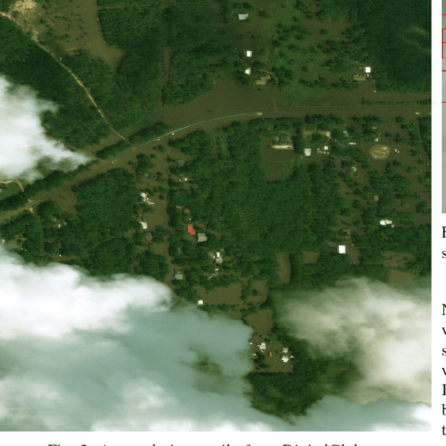
Abstract:Rapid damage assessment is of crucial importance to emergency responders during hurricane events, however, the evaluation process is often slow, labor-intensive, costly, and error-prone. New advances in computer vision and remote sensing open possibilities to observe the Earth at a different scale. However, substantial pre-processing work is still required in order to apply state-of-the-art methodology for emergency response. To enable the comparison of methods for automatic detection of damaged buildings from post-hurricane remote sensing imagery taken from both airborne and satellite sensors, this paper presents the development of benchmark datasets from publicly available data. The major contributions of this work include (1) a scalable framework for creating benchmark datasets of hurricane-damaged buildings and (2) public sharing of the resulting benchmark datasets for Greater Houston area after Hurricane Harvey in 2017. The proposed approach can be used to build other hurricane-damaged building datasets on which researchers can train and test object detection models to automatically identify damaged buildings.
Deep Learning Based Damage Detection on Post-Hurricane Satellite Imagery
Jul 04, 2018


Abstract:After a hurricane, damage assessment is critical to emergency managers and first responders. To improve the efficiency and accuracy of damage assessment, instead of using windshield survey, we propose to automatically detect damaged buildings using image classification algorithms. The method is applied to the case study of 2017 Hurricane Harvey.
 Add to Chrome
 Add to Firefox
 Add to Edge