Xiangxi Tian
T-GMSI: A transformer-based generative model for spatial interpolation under sparse measurements
Dec 13, 2024


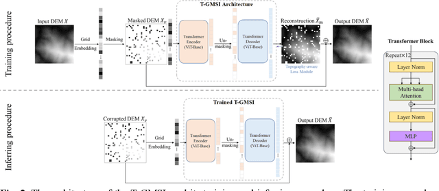
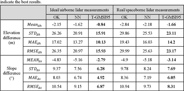
Abstract:Generating continuous environmental models from sparsely sampled data is a critical challenge in spatial modeling, particularly for topography. Traditional spatial interpolation methods often struggle with handling sparse measurements. To address this, we propose a Transformer-based Generative Model for Spatial Interpolation (T-GMSI) using a vision transformer (ViT) architecture for digital elevation model (DEM) generation under sparse conditions. T-GMSI replaces traditional convolution-based methods with ViT for feature extraction and DEM interpolation while incorporating a terrain feature-aware loss function for enhanced accuracy. T-GMSI excels in producing high-quality elevation surfaces from datasets with over 70% sparsity and demonstrates strong transferability across diverse landscapes without fine-tuning. Its performance is validated through extensive experiments, outperforming traditional methods such as ordinary Kriging (OK) and natural neighbor (NN) and a conditional generative adversarial network (CGAN)-based model (CEDGAN). Compared to OK and NN, T-GMSI reduces root mean square error (RMSE) by 40% and 25% on airborne lidar data and by 23% and 10% on spaceborne lidar data. Against CEDGAN, T-GMSI achieves a 20% RMSE improvement on provided DEM data, requiring no fine-tuning. The ability of model on generalizing to large, unseen terrains underscores its transferability and potential applicability beyond topographic modeling. This research establishes T-GMSI as a state-of-the-art solution for spatial interpolation on sparse datasets and highlights its broader utility for other sparse data interpolation challenges.
 Add to Chrome
 Add to Firefox
 Add to Edge