Tuong Vy Nguyen
Generating Synthetic Satellite Imagery for Rare Objects: An Empirical Comparison of Models and Metrics
Sep 02, 2024


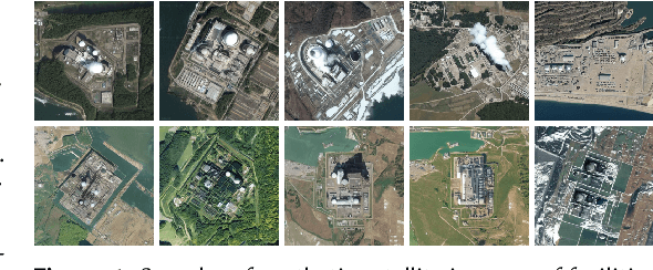
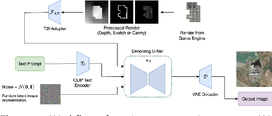
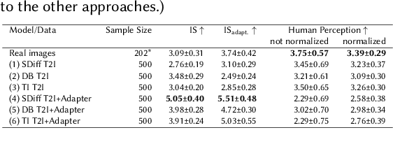
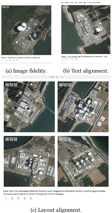
Abstract:Generative deep learning architectures can produce realistic, high-resolution fake imagery -- with potentially drastic societal implications. A key question in this context is: How easy is it to generate realistic imagery, in particular for niche domains. The iterative process required to achieve specific image content is difficult to automate and control. Especially for rare classes, it remains difficult to assess fidelity, meaning whether generative approaches produce realistic imagery and alignment, meaning how (well) the generation can be guided by human input. In this work, we present a large-scale empirical evaluation of generative architectures which we fine-tuned to generate synthetic satellite imagery. We focus on nuclear power plants as an example of a rare object category - as there are only around 400 facilities worldwide, this restriction is exemplary for many other scenarios in which training and test data is limited by the restricted number of occurrences of real-world examples. We generate synthetic imagery by conditioning on two kinds of modalities, textual input and image input obtained from a game engine that allows for detailed specification of the building layout. The generated images are assessed by commonly used metrics for automatic evaluation and then compared with human judgement from our conducted user studies to assess their trustworthiness. Our results demonstrate that even for rare objects, generation of authentic synthetic satellite imagery with textual or detailed building layouts is feasible. In line with previous work, we find that automated metrics are often not aligned with human perception -- in fact, we find strong negative correlations between commonly used image quality metrics and human ratings.
Using Game Engines and Machine Learning to Create Synthetic Satellite Imagery for a Tabletop Verification Exercise
Apr 17, 2024


Abstract:Satellite imagery is regarded as a great opportunity for citizen-based monitoring of activities of interest. Relevant imagery may however not be available at sufficiently high resolution, quality, or cadence -- let alone be uniformly accessible to open-source analysts. This limits an assessment of the true long-term potential of citizen-based monitoring of nuclear activities using publicly available satellite imagery. In this article, we demonstrate how modern game engines combined with advanced machine-learning techniques can be used to generate synthetic imagery of sites of interest with the ability to choose relevant parameters upon request; these include time of day, cloud cover, season, or level of activity onsite. At the same time, resolution and off-nadir angle can be adjusted to simulate different characteristics of the satellite. While there are several possible use-cases for synthetic imagery, here we focus on its usefulness to support tabletop exercises in which simple monitoring scenarios can be examined to better understand verification capabilities enabled by new satellite constellations and very short revisit times.
Generating Synthetic Satellite Imagery With Deep-Learning Text-to-Image Models -- Technical Challenges and Implications for Monitoring and Verification
Apr 11, 2024Abstract:Novel deep-learning (DL) architectures have reached a level where they can generate digital media, including photorealistic images, that are difficult to distinguish from real data. These technologies have already been used to generate training data for Machine Learning (ML) models, and large text-to-image models like DALL-E 2, Imagen, and Stable Diffusion are achieving remarkable results in realistic high-resolution image generation. Given these developments, issues of data authentication in monitoring and verification deserve a careful and systematic analysis: How realistic are synthetic images? How easily can they be generated? How useful are they for ML researchers, and what is their potential for Open Science? In this work, we use novel DL models to explore how synthetic satellite images can be created using conditioning mechanisms. We investigate the challenges of synthetic satellite image generation and evaluate the results based on authenticity and state-of-the-art metrics. Furthermore, we investigate how synthetic data can alleviate the lack of data in the context of ML methods for remote-sensing. Finally we discuss implications of synthetic satellite imagery in the context of monitoring and verification.
* https://resources.inmm.org/annual-meeting-proceedings/generating-synthetic-satellite-imagery-deep-learning-text-image-models
 Add to Chrome
 Add to Firefox
 Add to Edge