 Add to Chrome
 Add to Firefox
 Add to Edge
ChromaFormer: A Scalable and Accurate Transformer Architecture for Land Cover Classification
Mar 11, 2025Remote sensing imagery from systems such as Sentinel provides full coverage of the Earth's surface at around 10-meter resolution. The remote sensing community has transitioned to extensive use of deep learning models due to their high performance on benchmarks such as the UCMerced and ISPRS Vaihingen datasets. Convolutional models such as UNet and ResNet variations are commonly employed for remote sensing but typically only accept three channels, as they were developed for RGB imagery, while satellite systems provide more than ten. Recently, several transformer architectures have been proposed for remote sensing, but they have not been extensively benchmarked and are typically used on small datasets such as Salinas Valley. Meanwhile, it is becoming feasible to obtain dense spatial land-use labels for entire first-level administrative divisions of some countries. Scaling law observations suggest that substantially larger multi-spectral transformer models could provide a significant leap in remote sensing performance in these settings. In this work, we propose ChromaFormer, a family of multi-spectral transformer models, which we evaluate across orders of magnitude differences in model parameters to assess their performance and scaling effectiveness on a densely labeled imagery dataset of Flanders, Belgium, covering more than 13,500 km^2 and containing 15 classes. We propose a novel multi-spectral attention strategy and demonstrate its effectiveness through ablations. Furthermore, we show that models many orders of magnitude larger than conventional architectures, such as UNet, lead to substantial accuracy improvements: a UNet++ model with 23M parameters achieves less than 65% accuracy, while a multi-spectral transformer with 655M parameters achieves over 95% accuracy on the Biological Valuation Map of Flanders.
Biological Valuation Map of Flanders: A Sentinel-2 Imagery Analysis
Jan 26, 2024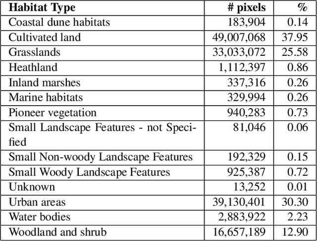
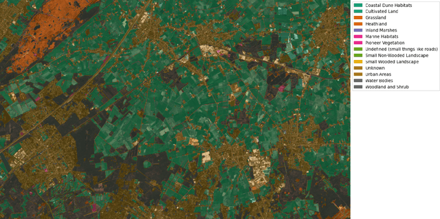
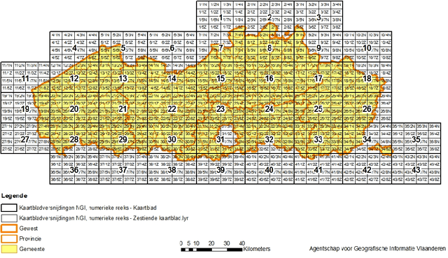
In recent years, machine learning has become crucial in remote sensing analysis, particularly in the domain of Land-use/Land-cover (LULC). The synergy of machine learning and satellite imagery analysis has demonstrated significant productivity in this field, as evidenced by several studies. A notable challenge within this area is the semantic segmentation mapping of land usage over extensive territories, where the accessibility of accurate land-use data and the reliability of ground truth land-use labels pose significant difficulties. For example, providing a detailed and accurate pixel-wise labeled dataset of the Flanders region, a first-level administrative division of Belgium, can be particularly insightful. Yet there is a notable lack of regulated, formalized datasets and workflows for such studies in many regions globally. This paper introduces a comprehensive approach to addressing these gaps. We present a densely labeled ground truth map of Flanders paired with Sentinel-2 satellite imagery. Our methodology includes a formalized dataset division and sampling method, utilizing the topographic map layout 'Kaartbladversnijdingen,' and a detailed semantic segmentation model training pipeline. Preliminary benchmarking results are also provided to demonstrate the efficacy of our approach.