Santiago Peña Luque
Assimilation of SWOT Altimetry Data for Riverine Flood Reanalysis: From Synthetic to Real Data
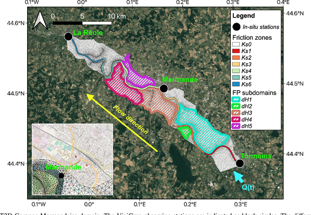
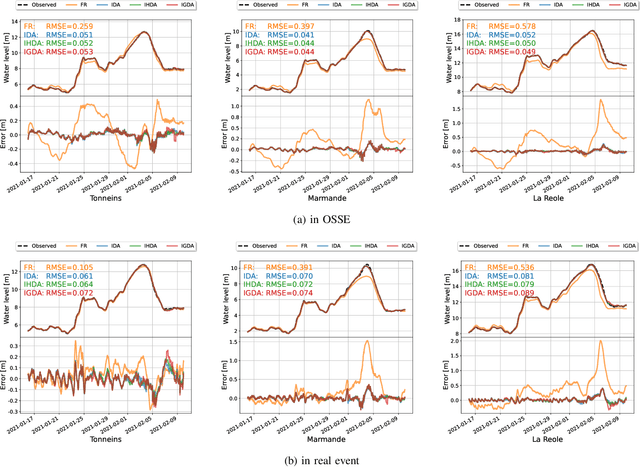
Apr 30, 2025Abstract:Floods are one of the most common and devastating natural disasters worldwide. The contribution of remote sensing is important for reducing the impact of flooding both during the event itself and for improving hydrodynamic models by reducing their associated uncertainties. This article presents the innovative capabilities of the Surface Water and Ocean Topography (SWOT) mission, especially its river node products, to enhance the accuracy of riverine flood reanalysis, performed on a 50-km stretch of the Garonne River. The experiments incorporate various data assimilation strategies, based on the ensemble Kalman filter (EnKF), which allows for sequential updates of model parameters based on available observations. The experimental results show that while SWOT data alone offers some improvements, combining it with in-situ water level measurements provides the most accurate representation of flood dynamics, both at gauge stations and along the river. The study also investigates the impact of different SWOT revisit frequencies on the models performance, revealing that assimilating more frequent SWOT observations leads to more reliable flood reanalyses. In the real event, it was demonstrated that the assimilation of SWOT and in-situ data accurately reproduces the water level dynamics, offering promising prospects for future flood monitoring systems. Overall, this study emphasizes the complementary strengths of Earth Observation data in improving the representation of the flood dynamics in the riverbed and the floodplains.
Assimilation of SWOT Altimetry and Sentinel-1 Flood Extent Observations for Flood Reanalysis -- A Proof-of-Concept
Mar 21, 2024Abstract:In spite of astonishing advances and developments in remote sensing technologies, meeting the spatio-temporal requirements for flood hydrodynamic modeling remains a great challenge for Earth Observation. The assimilation of multi-source remote sensing data in 2D hydrodynamic models participates to overcome such a challenge. The recently launched Surface Water and Ocean Topography (SWOT) wide-swath altimetry satellite provides a global coverage of water surface elevation at a high resolution. SWOT provides complementary observation to radar and optical images, increasing the opportunity to observe and monitor flood events. This research work focuses on the assimilation of 2D flood extent maps derived from Sentinel-1 C-SAR imagery data, and water surface elevation from SWOT as well as in-situ water level measurements. An Ensemble Kalman Filter (EnKF) with a joint state-parameter analysis is implemented on top of a 2D hydrodynamic TELEMAC-2D model to account for errors in roughness, input forcing and water depth in floodplain subdomains. The proposed strategy is carried out in an Observing System Simulation Experiment based on the 2021 flood event over the Garonne Marmandaise catchment. This work makes the most of the large volume of heterogeneous data from space for flood prediction in hindcast mode paves the way for nowcasting.
Reducing Uncertainties of a Chained Hydrologic-hydraulic Model to Improve Flood Forecasting Using Multi-source Earth Observation Data
Jun 14, 2023Abstract:The challenges in operational flood forecasting lie in producing reliable forecasts given constrained computational resources and within processing times that are compatible with near-real-time forecasting. Flood hydrodynamic models exploit observed data from gauge networks, e.g. water surface elevation (WSE) and/or discharge that describe the forcing time-series at the upstream and lateral boundary conditions of the model. A chained hydrologic-hydraulic model is thus interesting to allow extended lead time forecasts and overcome the limits of forecast when using only observed gauge measurements. This research work focuses on comprehensively reducing the uncertainties in the model parameters, hydraulic state and especially the forcing data in order to improve the overall flood reanalysis and forecast performance. It aims at assimilating two main complementary EO data sources, namely in-situ WSE and SAR-derived flood extent observations.
Dealing With Non-Gaussianity of SAR-derived Wet Surface Ratio for Flood Extent Representation Improvement
Jun 14, 2023Abstract:Owing to advances in data assimilation, notably Ensemble Kalman Filter (EnKF), flood simulation and forecast capabilities have greatly improved in recent years. The motivation of the research work is to reduce comprehensively the uncertainties in the model parameters, forcing and hydraulic state, and consequently improve the overall flood reanalysis and forecast capability, especially in the floodplain. It aims at assimilating SAR-derived (typically from Sentinel-1 mission) flood extent observations, expressed in terms of wet surface ratio. The non-Gaussianity of the observation errors associated with the SAR flood observations violates a major hypothesis regarding the EnKF and jeopardizes the optimality of the filter analysis. Therefore, a special treatment of such non-Gaussianity with a Gaussian anamorphosis process is thus proposed. This strategy was validated and applied over the Garonne Marmandaise catchment (Southwest of France) represented with the TELEMAC-2D hydrodynamic model, focusing on a major flood event that occurred in December 2019. The assimilation of the SAR-derived wet surface ratio observations, in complement to the in-situ water surface elevations, is illustrated to consequentially improve the flood representation.
Gaussian Anamorphosis for Ensemble Kalman Filter Analysis of SAR-Derived Wet Surface Ratio Observations
Apr 03, 2023


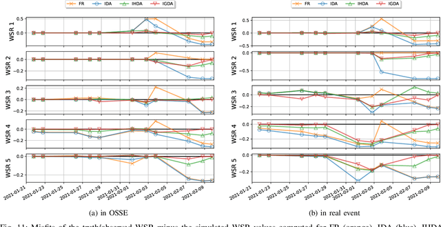
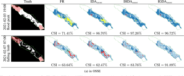
Abstract:Flood simulation and forecast capability have been greatly improved thanks to advances in data assimilation (DA) strategies incorporating various types of observations; many are derived from spatial Earth Observation. This paper focuses on the assimilation of 2D flood observations derived from Synthetic Aperture Radar (SAR) images acquired during a flood event with a dual state-parameter Ensemble Kalman Filter (EnKF). Binary wet/dry maps are here expressed in terms of wet surface ratios (WSR) over a number of subdomains of the floodplain. This ratio is further assimilated jointly with in-situ water-level observations to improve the flow dynamics within the floodplain. However, the non-Gaussianity of the observation errors associated with SAR-derived measurements break a major hypothesis for the application of the EnKF, thus jeopardizing the optimality of the filter analysis. The novelty of this paper lies in the treatment of the non-Gaussianity of the SAR-derived WSR observations with a Gaussian anamorphosis process (GA). This DA strategy was validated and applied over the Garonne Marmandaise catchment (South-west of France) represented with the TELEMAC-2D hydrodynamic model, first in a twin experiment and then for a major flood event that occurred in January-February 2021. It was shown that assimilating SAR-derived WSR observations, in complement to the in-situ water-level observations significantly improves the representation of the flood dynamics. Also, the GA transformation brings further improvement to the DA analysis, while not being a critical component in the DA strategy. This study heralds a reliable solution for flood forecasting over poorly gauged catchments thanks to available remote-sensing datasets.
 Add to Chrome
 Add to Firefox
 Add to Edge