Sajid Ghuffar
Deep Learning for automated multi-scale functional field boundaries extraction using multi-date Sentinel-2 and PlanetScope imagery: Case Study of Netherlands and Pakistan
Nov 24, 2024


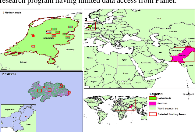
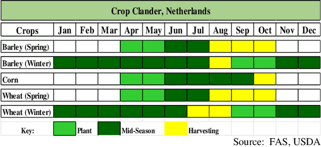
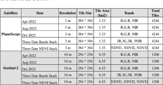
Abstract:This study explores the effectiveness of multi-temporal satellite imagery for better functional field boundary delineation using deep learning semantic segmentation architecture on two distinct geographical and multi-scale farming systems of Netherlands and Pakistan. Multidate images of April, August and October 2022 were acquired for PlanetScope and Sentinel-2 in sub regions of Netherlands and November 2022, February and March 2023 for selected area of Dunyapur in Pakistan. For Netherlands, Basic registration crop parcels (BRP) vector layer was used as labeled training data. while self-crafted field boundary vector data were utilized for Pakistan. Four deep learning models with UNET architecture were evaluated using different combinations of multi-date images and NDVI stacks in the Netherlands subregions. A comparative analysis of IoU scores assessed the effectiveness of the proposed multi-date NDVI stack approach. These findings were then applied for transfer learning, using pre-trained models from the Netherlands on the selected area in Pakistan. Additionally, separate models were trained using self-crafted field boundary data for Pakistan, and combined models were developed using data from both the Netherlands and Pakistan. Results indicate that multi-date NDVI stacks provide additional temporal context, reflecting crop growth over different times of the season. The study underscores the critical role of multi-scale ground information from diverse geographical areas in developing robust and universally applicable models for field boundary delineation. The results also highlight the importance of fine spatial resolution for extraction of field boundaries in regions with small scale framing. The findings can be extended to multi-scale implementations for improved automatic field boundary delineation in heterogeneous agricultural environments.
A pipeline for automated processing of Corona KH-4 stereo imagery
Jan 19, 2022


Abstract:The Corona KH-4 reconnaissance satellite missions from 1962-1972 acquired panoramic stereo imagery with high spatial resolution of 1.8-7.5 m. The potential of 800,000+ declassified Corona images has not been leveraged due to the complexities arising from handling of panoramic imaging geometry, film distortions and limited availability of the metadata required for georeferencing of the Corona imagery. This paper presents Corona Stereo Pipeline (CoSP): A pipeline for processing of Corona KH-4 stereo panoramic imagery. CoSP utlizes a deep learning based feature matcher SuperGlue to automatically match features point between Corona KH-4 images and recent satellite imagery to generate Ground Control Points (GCPs). To model the imaging geometry and the scanning motion of the panoramic KH-4 cameras, a rigorous camera model consisting of modified collinearity equations with time dependent exterior orientation parameters is employed. The results show that using the entire frame of the Corona image, bundle adjustment using well-distributed GCPs results in an average standard deviation (SD) of less than 2 pixels. The distortion pattern of image residuals of GCPs and y-parallax in epipolar resampled images suggest that film distortions due to long term storage as likely cause of systematic deviations. Compared to the SRTM DEM, the Corona DEM computed using CoSP achieved a Normalized Median Absolute Deviation (NMAD) of elevation differences of ~4 m over an area of approx. 4000 $km^2$. We show that the proposed pipeline can be applied to sequence of complex scenes involving high relief and glacierized terrain and that the resulting DEMs can be used to compute long term glacier elevation changes over large areas.
Automated Classification of Airborne Laser Scanning Point Clouds
Apr 16, 2014


Abstract:Making sense of the physical world has always been at the core of mapping. Up until recently, this has always dependent on using the human eye. Using airborne lasers, it has become possible to quickly "see" more of the world in many more dimensions. The resulting enormous point clouds serve as data sources for applications far beyond the original mapping purposes ranging from flooding protection and forestry to threat mitigation. In order to process these large quantities of data, novel methods are required. In this contribution, we develop models to automatically classify ground cover and soil types. Using the logic of machine learning, we critically review the advantages of supervised and unsupervised methods. Focusing on decision trees, we improve accuracy by including beam vector components and using a genetic algorithm. We find that our approach delivers consistently high quality classifications, surpassing classical methods.
 Add to Chrome
 Add to Firefox
 Add to Edge