S Manthira Moorthi
CVPR MultiEarth 2023 Deforestation Estimation Challenge:SpaceVision4Amazon
Jul 10, 2023Abstract:In this paper, we present a deforestation estimation method based on attention guided UNet architecture using Electro-Optical (EO) and Synthetic Aperture Radar (SAR) satellite imagery. For optical images, Landsat-8 and for SAR imagery, Sentinel-1 data have been used to train and validate the proposed model. Due to the unavailability of temporally and spatially collocated data, individual model has been trained for each sensor. During training time Landsat-8 model achieved training and validation pixel accuracy of 93.45% and Sentinel-2 model achieved 83.87% pixel accuracy. During the test set evaluation, the model achieved pixel accuracy of 84.70% with F1-Score of 0.79 and IoU of 0.69.
Monte-Carlo Siamese Policy on Actor for Satellite Image Super Resolution
Apr 08, 2020
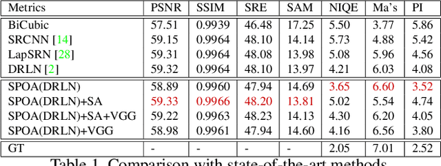
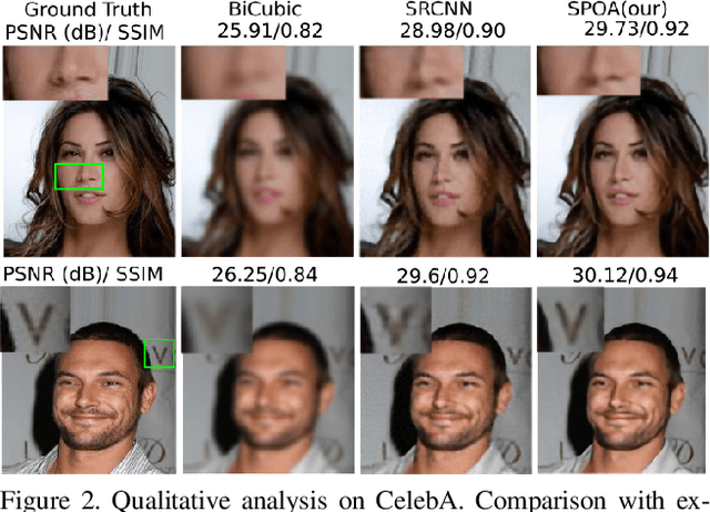
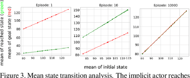
Abstract:In the past few years supervised and adversarial learning have been widely adopted in various complex computer vision tasks. It seems natural to wonder whether another branch of artificial intelligence, commonly known as Reinforcement Learning (RL) can benefit such complex vision tasks. In this study, we explore the plausible usage of RL in super resolution of remote sensing imagery. Guided by recent advances in super resolution, we propose a theoretical framework that leverages the benefits of supervised and reinforcement learning. We argue that a straightforward implementation of RL is not adequate to address ill-posed super resolution as the action variables are not fully known. To tackle this issue, we propose to parameterize action variables by matrices, and train our policy network using Monte-Carlo sampling. We study the implications of parametric action space in a model-free environment from theoretical and empirical perspective. Furthermore, we analyze the quantitative and qualitative results on both remote sensing and non-remote sensing datasets. Based on our experiments, we report considerable improvement over state-of-the-art methods by encapsulating supervised models in a reinforcement learning framework.
S2A: Wasserstein GAN with Spatio-Spectral Laplacian Attention for Multi-Spectral Band Synthesis
Apr 08, 2020


Abstract:Intersection of adversarial learning and satellite image processing is an emerging field in remote sensing. In this study, we intend to address synthesis of high resolution multi-spectral satellite imagery using adversarial learning. Guided by the discovery of attention mechanism, we regulate the process of band synthesis through spatio-spectral Laplacian attention. Further, we use Wasserstein GAN with gradient penalty norm to improve training and stability of adversarial learning. In this regard, we introduce a new cost function for the discriminator based on spatial attention and domain adaptation loss. We critically analyze the qualitative and quantitative results compared with state-of-the-art methods using widely adopted evaluation metrics. Our experiments on datasets of three different sensors, namely LISS-3, LISS-4, and WorldView-2 show that attention learning performs favorably against state-of-the-art methods. Using the proposed method we provide an additional data product in consistent with existing high resolution bands. Furthermore, we synthesize over 4000 high resolution scenes covering various terrains to analyze scientific fidelity. At the end, we demonstrate plausible large scale real world applications of the synthesized band.
DeepSWIR: A Deep Learning Based Approach for the Synthesis of Short-Wave InfraRed Band using Multi-Sensor Concurrent Datasets
May 07, 2019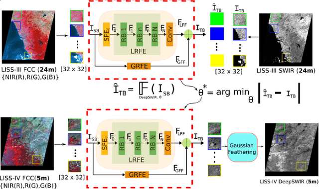
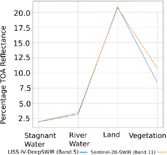
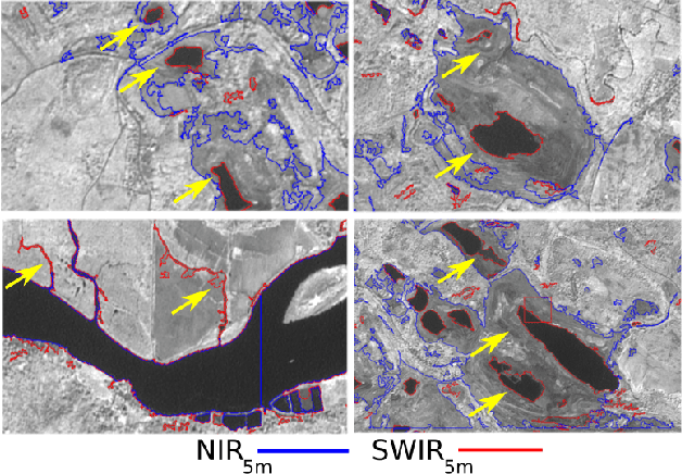
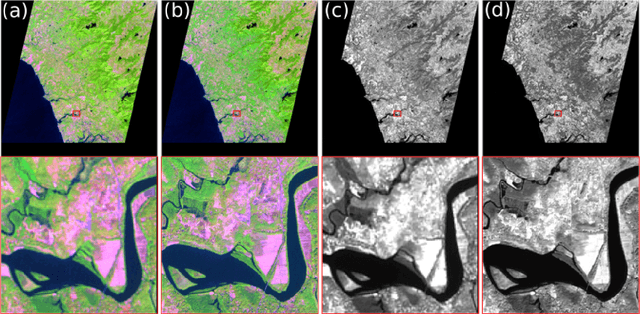
Abstract:Convolutional Neural Network (CNN) is achieving remarkable progress in various computer vision tasks. In the past few years, the remote sensing community has observed Deep Neural Network (DNN) finally taking off in several challenging fields. In this study, we propose a DNN to generate a predefined High Resolution (HR) synthetic spectral band using an ensemble of concurrent Low Resolution (LR) bands and existing HR bands. Of particular interest, the proposed network, namely DeepSWIR, synthesizes Short-Wave InfraRed (SWIR) band at 5m Ground Sampling Distance (GSD) using Green (G), Red (R) and Near InfraRed (NIR) bands at both 24m and 5m GSD, and SWIR band at 24m GSD. To our knowledge, the highest spatial resolution of commercially deliverable SWIR band is at 7.5m GSD. Also, we propose a Gaussian feathering based image stitching approach in light of processing large satellite imagery. To experimentally validate the synthesized HR SWIR band, we critically analyse the qualitative and quantitative results produced by DeepSWIR using state-of-the-art evaluation metrics. Further, we convert the synthesized DN values to Top Of Atmosphere (TOA) reflectance and compare with the corresponding band of Sentinel-2B. Finally, we show one real world application of the synthesized band by using it to map wetland resources over our region of interest.
 Add to Chrome
 Add to Firefox
 Add to Edge