Preben Mogensen
Towards Reliable Connectivity: Measurement-Driven Assessment of Starlink and OneWeb Non-Terrestrial and 5G Terrestrial Networks
Dec 22, 2025


Abstract:The emergence of commercial satellite communications networks, such as Starlink and OneWeb, has significantly transformed the communications landscape over the last years. As a complement to terrestrial cellular networks, non-terrestrial systems enable coverage extension and reliability enhancement beyond the limits of conventional infrastructure. Currently, the high reliance on terrestrial networks exposes communications to vulnerabilities in the event of terrestrial infrastructure failures, e.g., due to natural disasters. Therefore, this work proposes the joint evaluation of Key Performance Indicators (KPIs) for two non-terrestrial satellite networks (Starlink and OneWeb) and two terrestrial cellular networks to assess the current performance of these technologies across three different environments: (i) urban, (ii) suburban, and (iii) forest scenarios. Additionally, multi-connectivity techniques are explored to determine the benefits in connectivity when two technologies are used simultaneously. For instance, the outage probability of Starlink and OneWeb in urban areas is reduced from approximately 12-21\% to 2\% when both solutions are employed together. Finally, the joint analysis of KPIs in both terrestrial and non-terrestrial networks demonstrates that their integration enhances coverage, improves performance, and increases reliability, highlighting the benefits of combining satellite and terrestrial systems in the analyzed environments.
Multi-Connectivity Solutions for Rural Areas: Integrating Terrestrial 5G and Satellite Networks to Support Innovative IoT Use Cases
Nov 11, 2024Abstract:5G cellular networks are now a reality and promise to improve key performance indicators (KPIs), such as Gbps data rates and latencies in the order of milliseconds. While some of these KPIs are achievable in urban scenarios, rural areas often face challenging connectivity conditions due to the lack of terrestrial network (TN) infrastructure. To solve this problem, non-terrestrial networks (NTNs) such as satellite-based solutions, have been introduced to provide coverage in remote regions. Therefore, a multi-connectivity approach can be integrated to simultaneously serve an end-user by merging satellite and cellular links in a joint approach. This study explores, using experimental data, the benefits of both TN-TN and TN-NTN multi-connectivity in rural environments. The results obtained demonstrate that a traditional single-connectivity approach may not be sufficient to provide service to rural environments due to the KPIs requirements given several use cases within these rural areas. The multi-connectivity strategy, which jointly integrates 5G and satellite networks, meets the network availability requirements for latency, downlink throughput, and uplink throughput KPIs at least 98%, 99%, and 95% of the time, respectively, for several use cases, such as precision agriculture, livestock monitoring, and forest management. These include applications like microclimate monitoring, remote operational support, early pest detection, and real-time tracking of livestock transport.
Observations on Large-Scale Attenuation Effects in a 26 GHz Urban Micro-Cell Environment
Apr 08, 2024Abstract:This letter presents a measurement campaign carried out in an FR2 urban outdoor environment in a live experimental network deployment. The radio propagation analysis from a physical perspective at 26 GHz is essential for the correct deployment and dimensioning of future communication networks. This study summarises and evaluates some of the typical effects encountered in a communications scenario such as penetration losses in a building, losses due to vegetation or the human body, or diffraction/scattering propagation around corners in street canyon-like environment given a FR2 live network.
FR2 5G Networks for Industrial Scenarios: An Experimental Characterization and Beam Management Procedures in Operational Conditions
Aug 17, 2023


Abstract:Industrial environments constitute a challenge in terms of radio propagation due to the presence of machinery and the mobility of the different agents, especially at mmWave bands. This paper presents an experimental evaluation of a FR2 5G network deployed in an operational factory scenario at 26 GHz. The experimental characterization, performed with autonomous mobile robots that self-navigate the industrial lab, leads to the analysis of the received power along the factory and the evaluation of reference path gain models. The proposed assessment deeply analyzes the physical layer of the communication network under operational conditions. Thus, two different network configurations are assessed by measuring the power received in the entire factory, providing a comparison between deployments. Additionally, beam management procedures, such as beam recovery, beam sweeping or beam switching, are analyzed since they are crucial in environments where mobile agents are involved. They aim for a zero interruption approach based on reliable communications. The results analysis shows that beam recovery procedures can perform a beam switching to an alternative serving beam with power losses of less than 1.6 dB on average. Beam sweeping analysis demonstrates the prevalence of the direct component in Line-of-Sight conditions despite the strong scattering component and large-scale fading in the environment.
DRaGon: Mining Latent Radio Channel Information from Geographical Data Leveraging Deep Learning
Dec 15, 2021


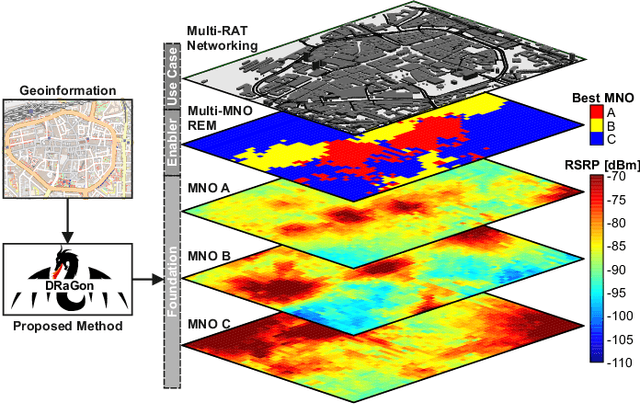
Abstract:Radio channel modeling is one of the most fundamental aspects in the process of designing, optimizing, and simulating wireless communication networks. In this field, long-established approaches such as analytical channel models and ray tracing techniques represent the de-facto standard methodologies. However, as demonstrated by recent results, there remains an untapped potential to innovate this research field by enriching model-based approaches with machine learning techniques. In this paper, we present Deep RAdio channel modeling from GeOinformatioN (DRaGon) as a novel machine learning-enabled method for automatic generation of Radio Environmental Maps (REMs) from geographical data. For achieving accurate path loss prediction results, DRaGon combines determining features extracted from a three-dimensional model of the radio propagation environment with raw images of the receiver area within a deep learning model. In a comprehensive performance evaluation and validation campaign, we compare the accuracy of the proposed approach with real world measurements, ray tracing analyses, and well-known channel models. It is found that the combination of expert knowledge from the communications domain and the data analysis capabilities of deep learning allows to achieve a significantly higher prediction accuracy than the reference methods.
 Add to Chrome
 Add to Firefox
 Add to Edge