Peter Kettig
Enhancing Flood Forecasting with Dual State-Parameter Estimation and Ensemble-based SAR Data Assimilation
Nov 14, 2022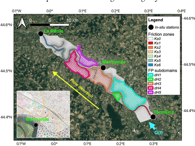
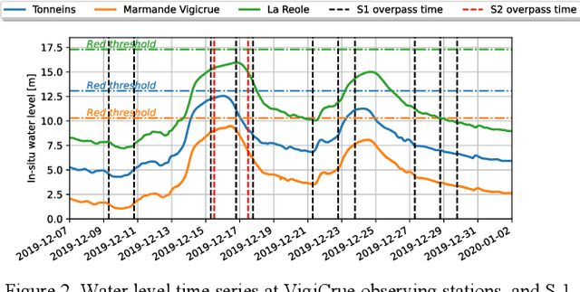
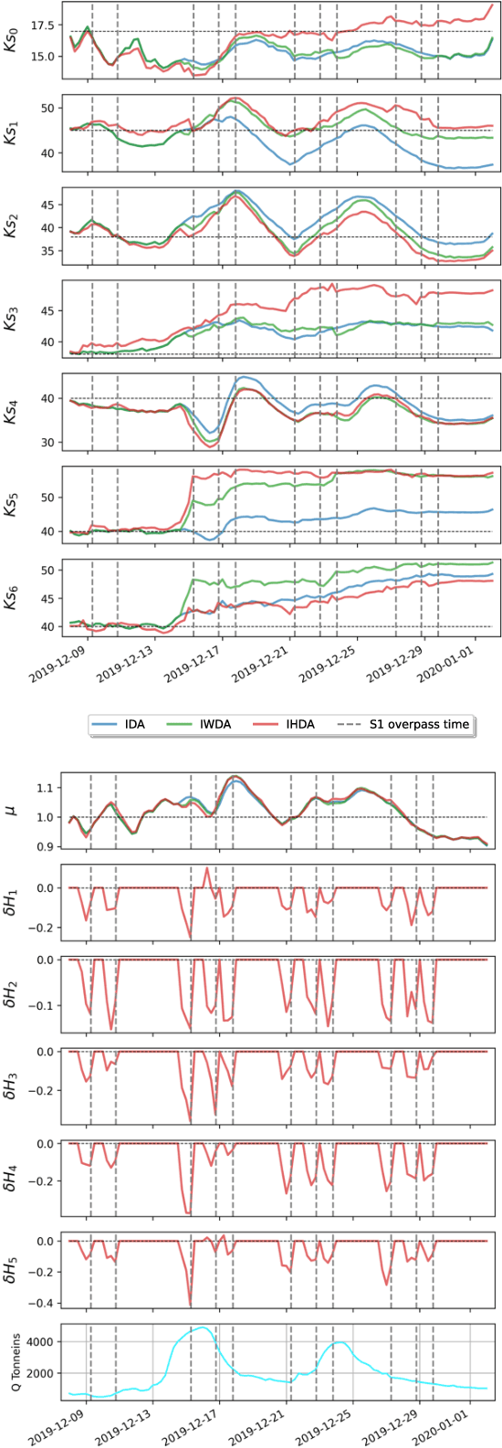
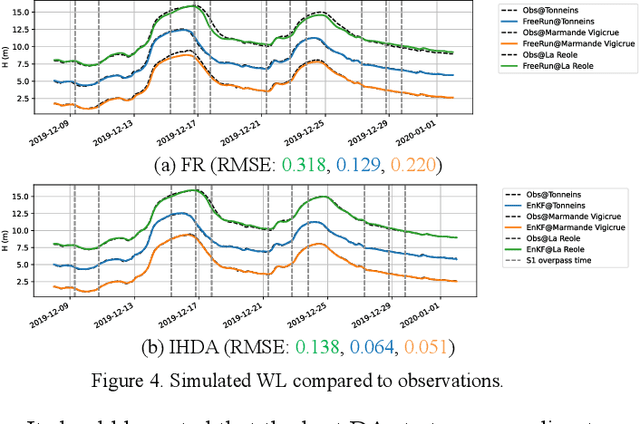
Abstract:Ensemble data assimilation in flood forecasting depends strongly on the density, frequency and statistics of errors associated with the observation network. This work focuses on the assimilation of 2D flood extent data, expressed in terms of wet surface ratio, in addition to the in-situ water level data. The objective is to improve the representation of the flood plain dynamics with a TELEMAC-2D model and an Ensemble Kalman Filter (EnKF). The EnKF control vector is composed of friction coefficients and corrective parameters to the input forcing. It is augmented with the water level state averaged over selected subdomains of the floodplain. This work focuses on the 2019 flood event that occurred over the Garonne Marmandaise catchment. The merits of assimilating SAR-derived flood plain data complementary to in-situ water level observations are shown in the control parameter and observation spaces with 1D and 2D assessment metrics. It was also shown that the assimilation of Wet surface Ratio in the flood plain complementary to in-situ data in the river bed brings significative improvement when a corrective term on flood plain hydraulic state is included in the control vector. Yet, it has barely no impact in the river bed that is sufficiently well described by in-situ data. We highlighted that the correction of the hydraulic state in the flood plain significantly improved the flood dynamics, especially during the recession. This proof-of-concept study paves the way towards near-real-time flood forecast, making the most of remote sensing-derived flood observations.
Assimilation of SAR-derived Flood Observations for Improving Fluvial Flood Forecast
May 17, 2022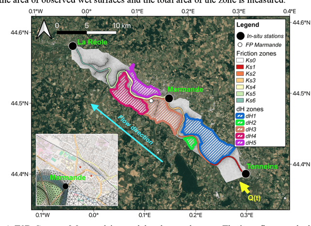

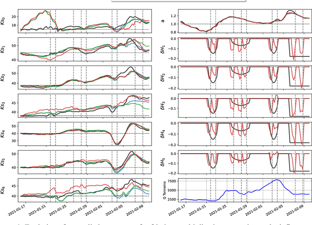

Abstract:As the severity and occurrence of flood events tend to intensify with climate change, the need for flood forecasting capability increases. In this regard, the Flood Detection, Alert and rapid Mapping (FloodDAM) project, funded by Space for Climate Observatory initiatives, was set out to develop pre-operational tools dedicated to enabling quick responses in flood-prone areas, and to improve the reactivity of decision support systems. This work focuses on the assimilation of 2D flood extent data (expressed in terms of wet surface ratios) and in-situ water level data to improve the representation of the flood plain dynamics with a Telemac-2D model and an Ensemble Kalman Filter (EnKF). The EnKF control vector was composed friction coefficients and corrective parameter to the input forcing. It is then augmented with the water level state averaged over several floodplain zones. This work was conducted in the context of Observing System Simulation Experiments (OSSE) based on a real flood event occurred in January-February 2021 on the Garonne Marmandaise catchment. This allows to validate the observation operator associated to the wet surface ratio observations as well as the dual state-parameter sequential correction implemented in this work. The merits of assimilating SAR- derived flood plain data complementary to in-situ water level observations are shown in the control parameter and observation spaces with 1D and 2D assessment metrics. It was also shown that the correction of the hydraulic state significantly improved the flood dynamics, especially during the recession. This proof-of-concept study paves the way towards near-real-time flood forecast, making the most of remote sensing-derived flood observations.
Validation and Improvement of Data Assimilation for Flood Hydrodynamic Modelling Using SAR Imagery Data
Sep 26, 2021


Abstract:Relevant comprehension of flood hazards has emerged as a crucial necessity, especially as the severity and the occurrence of flood events intensify with climate changes. Flood simulation and forecast capability have been greatly improved thanks to advances in data assimilation. This approach combines in-situ gauge measurements with hydrodynamic models, aiming to correct the hydraulic states and reduce the uncertainties in the model parameters, e.g., friction coefficients, inflow discharge. These methods depend strongly on the availability and quality of observations, thus requiring other data sources to improve the flood simulation and forecast quality. Sentinel-1 images collected during a flood event were used to classify an observed scene into dry and wet areas. The study area concerns the Garonne Marmandaise catchment, and focuses on recent flood event in January-February 2021. In this paper, seven experiments are carried out, two in free run modes (FR1 and FR2) and five in data assimilation modes (DA1 to DA5). A model-observation bias was diagnosed and corrected over the beginning of the flood event. Quantitative assessments are carried out involving 1D metrics at Vigicrue observing stations and 2D metrics with respect to the Sentinel-1 derived flood extent maps. They demonstrate improvements on flood extent representation thanks to the data assimilation and bias correction.
Improvement of Flood Extent Representation with Remote Sensing Data and Data Assimilation Applied to Hydrodynamic Numerical Models
Sep 17, 2021


Abstract:Flood simulation and forecast capability have been greatly improved thanks to advances in data assimilation. Such an approach combines in-situ gauge measurements with numerical hydrodynamic models to correct the hydraulic states and reduce the uncertainties in the model parameters. However, these methods depend strongly on the availability and quality of observations, thus necessitating other data sources to improve the flood simulation and forecast performances. Using Sentinel-1 images, a flood extent mapping method was carried out by applying a Random Forest algorithm trained on past flood events using manually delineated flood maps. The study area concerns a 50-km reach of the Garonne Marmandaise catchment. Two recent flood events are simulated in analysis and forecast modes, with a +24h lead time. This study demonstrates the merits of using SAR-derived flood extent maps to validate and improve the forecast results based on hydrodynamic numerical models with Telemac2D-EnKF. Quantitative 1D and 2D metrics were computed to assess water level time-series and flood extents between the simulations and observations. It was shown that the free run experiment without DA under-estimates flooding. On the other hand, the validation of DA results with respect to independent SAR-derived flood extent allows to diagnose a model-observation bias that leads to over-flooding. Once this bias is taken into account, DA provides a sequential correction of area-based friction coefficients and inflow discharge, yielding a better flood extent representation. This study paves the way towards a reliable solution for flood forecasting over poorly gauged catchments, thanks to available remote sensing datasets.
 Add to Chrome
 Add to Firefox
 Add to Edge