Mateusz Żarski
Beyond Accuracy: Uncovering the Role of Similarity Perception and its Alignment with Semantics in Supervised Learning
May 27, 2025Abstract:Similarity manifests in various forms, including semantic similarity that is particularly important, serving as an approximation of human object categorization based on e.g. shared functionalities and evolutionary traits. It also offers practical advantages in computational modeling via lexical structures such as WordNet with constant and interpretable similarity. As in the domain of deep vision, there is still not enough focus on the phenomena regarding the similarity perception emergence. We introduce Deep Similarity Inspector (DSI) -- a systematic framework to inspect how deep vision networks develop their similarity perception and its alignment with semantic similarity. Our experiments show that both Convolutional Neural Networks' (CNNs) and Vision Transformers' (ViTs) develop a rich similarity perception during training with 3 phases (initial similarity surge, refinement, stabilization), with clear differences between CNNs and ViTs. Besides the gradual mistakes elimination, the mistakes refinement phenomenon can be observed.
Semantic Depth Matters: Explaining Errors of Deep Vision Networks through Perceived Class Similarities
Apr 14, 2025Abstract:Understanding deep neural network (DNN) behavior requires more than evaluating classification accuracy alone; analyzing errors and their predictability is equally crucial. Current evaluation methodologies lack transparency, particularly in explaining the underlying causes of network misclassifications. To address this, we introduce a novel framework that investigates the relationship between the semantic hierarchy depth perceived by a network and its real-data misclassification patterns. Central to our framework is the Similarity Depth (SD) metric, which quantifies the semantic hierarchy depth perceived by a network along with a method of evaluation of how closely the network's errors align with its internally perceived similarity structure. We also propose a graph-based visualization of model semantic relationships and misperceptions. A key advantage of our approach is that leveraging class templates -- representations derived from classifier layer weights -- is applicable to already trained networks without requiring additional data or experiments. Our approach reveals that deep vision networks encode specific semantic hierarchies and that high semantic depth improves the compliance between perceived class similarities and actual errors.
Multi-step feature fusion for natural disaster damage assessment on satellite images
Oct 29, 2024Abstract:Quick and accurate assessment of the damage state of buildings after natural disasters is crucial for undertaking properly targeted rescue and subsequent recovery operations, which can have a major impact on the safety of victims and the cost of disaster recovery. The quality of such a process can be significantly improved by harnessing the potential of machine learning methods in computer vision. This paper presents a novel damage assessment method using an original multi-step feature fusion network for the classification of the damage state of buildings based on pre- and post-disaster large-scale satellite images. We introduce a novel convolutional neural network (CNN) module that performs feature fusion at multiple network levels between pre- and post-disaster images in the horizontal and vertical directions of CNN network. An additional network element - Fuse Module - was proposed to adapt any CNN model to analyze image pairs in the issue of pair classification. We use, open, large-scale datasets (IDA-BD and xView2) to verify, that the proposed method is suitable to improve on existing state-of-the-art architectures. We report over a 3 percentage point increase in the accuracy of the Vision Transformer model.
* 10 pages, for associated Github repository: https://github.com/MatZar01/EQ_vis
Computer Vision based inspection on post-earthquake with UAV synthetic dataset
Oct 11, 2022


Abstract:The area affected by the earthquake is vast and often difficult to entirely cover, and the earthquake itself is a sudden event that causes multiple defects simultaneously, that cannot be effectively traced using traditional, manual methods. This article presents an innovative approach to the problem of detecting damage after sudden events by using an interconnected set of deep machine learning models organized in a single pipeline and allowing for easy modification and swapping models seamlessly. Models in the pipeline were trained with a synthetic dataset and were adapted to be further evaluated and used with unmanned aerial vehicles (UAVs) in real-world conditions. Thanks to the methods presented in the article, it is possible to obtain high accuracy in detecting buildings defects, segmenting constructions into their components and estimating their technical condition based on a single drone flight.
Hard hat wearing detection based on head keypoint localization
Jun 21, 2021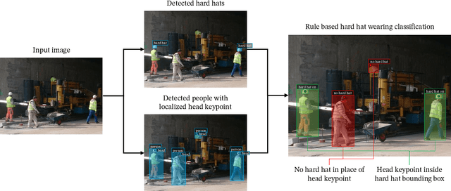
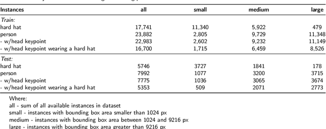
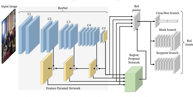
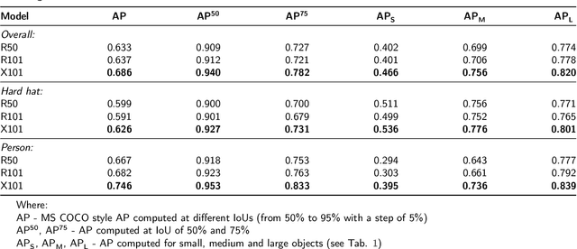
Abstract:In recent years, a lot of attention is paid to deep learning methods in the context of vision-based construction site safety systems, especially regarding personal protective equipment. However, despite all this attention, there is still no reliable way to establish the relationship between workers and their hard hats. To answer this problem a combination of deep learning, object detection and head keypoint localization, with simple rule-based reasoning is proposed in this article. In tests, this solution surpassed the previous methods based on the relative bounding box position of different instances, as well as direct detection of hard hat wearers and non-wearers. The results show that the conjunction of novel deep learning methods with humanly-interpretable rule-based systems can result in a solution that is both reliable and can successfully mimic manual, on-site supervision. This work is the next step in the development of fully autonomous construction site safety systems and shows that there is still room for improvement in this area.
Transfer learning for leveraging computer vision in infrastructure maintenance
Apr 26, 2020
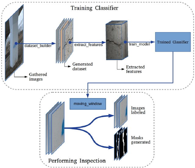
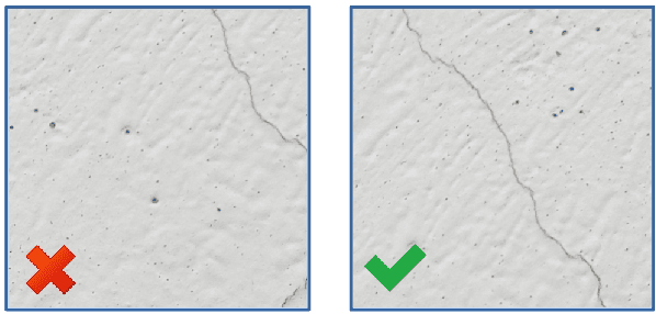

Abstract:Monitoring the technical condition of infrastructure is a crucial element to its maintenance. Currently, the applied methods are outdated, labour intensive and highly inaccurate. At the same time, the latest methods using Artificial Intelligence techniques, despite achieving satisfactory results in the detection of infrastructure damage, are severely limited in their application due to two main factors - labour-intensive gathering of new datasets and high demand for computing power. In the presented work, we propose to utilize Transfer Learning techniques and computer vision to overcome these limiting factor and fully harness the advantages of Artificial Intelligence methods. We describe a framework which enables hassle-free development of unique infrastructure defects detectors on digital images, achieving the accuracy of above 90%. The framework supports semi-automatic creation of new datasets and has modest computing power requirements. It is implemented in the form of a ready-to-use software package distributed under an open software licence and available for the public. Thus, it can be used to immediately implement the methods proposed in this paper in the process of infrastructure management by government units, regardless of their financial capabilities. With the help of introduced framework it is possible to improve the efficiency of infrastructure management and the quality of its life cycle documentation globally, leading to a more accurate mapping of the processes taking place in the infrastructure's life cycle for better infrastructure planning in the future.
 Add to Chrome
 Add to Firefox
 Add to Edge