Lulin Zhang
BRDF-NeRF: Neural Radiance Fields with Optical Satellite Images and BRDF Modelling
Sep 18, 2024Abstract:Understanding the anisotropic reflectance of complex Earth surfaces from satellite imagery is crucial for numerous applications. Neural radiance fields (NeRF) have become popular as a machine learning technique capable of deducing the bidirectional reflectance distribution function (BRDF) of a scene from multiple images. However, prior research has largely concentrated on applying NeRF to close-range imagery, estimating basic Microfacet BRDF models, which fall short for many Earth surfaces. Moreover, high-quality NeRFs generally require several images captured simultaneously, a rare occurrence in satellite imaging. To address these limitations, we propose BRDF-NeRF, developed to explicitly estimate the Rahman-Pinty-Verstraete (RPV) model, a semi-empirical BRDF model commonly employed in remote sensing. We assess our approach using two datasets: (1) Djibouti, captured in a single epoch at varying viewing angles with a fixed Sun position, and (2) Lanzhou, captured over multiple epochs with different viewing angles and Sun positions. Our results, based on only three to four satellite images for training, demonstrate that BRDF-NeRF can effectively synthesize novel views from directions far removed from the training data and produce high-quality digital surface models (DSMs).
SparseSat-NeRF: Dense Depth Supervised Neural Radiance Fields for Sparse Satellite Images
Sep 01, 2023


Abstract:Digital surface model generation using traditional multi-view stereo matching (MVS) performs poorly over non-Lambertian surfaces, with asynchronous acquisitions, or at discontinuities. Neural radiance fields (NeRF) offer a new paradigm for reconstructing surface geometries using continuous volumetric representation. NeRF is self-supervised, does not require ground truth geometry for training, and provides an elegant way to include in its representation physical parameters about the scene, thus potentially remedying the challenging scenarios where MVS fails. However, NeRF and its variants require many views to produce convincing scene's geometries which in earth observation satellite imaging is rare. In this paper we present SparseSat-NeRF (SpS-NeRF) - an extension of Sat-NeRF adapted to sparse satellite views. SpS-NeRF employs dense depth supervision guided by crosscorrelation similarity metric provided by traditional semi-global MVS matching. We demonstrate the effectiveness of our approach on stereo and tri-stereo Pleiades 1B/WorldView-3 images, and compare against NeRF and Sat-NeRF. The code is available at https://github.com/LulinZhang/SpS-NeRF
Feature matching for multi-epoch historical aerial images
Dec 08, 2021


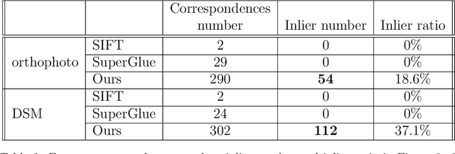
Abstract:Historical imagery is characterized by high spatial resolution and stereo-scopic acquisitions, providing a valuable resource for recovering 3D land-cover information. Accurate geo-referencing of diachronic historical images by means of self-calibration remains a bottleneck because of the difficulty to find sufficient amount of feature correspondences under evolving landscapes. In this research, we present a fully automatic approach to detecting feature correspondences between historical images taken at different times (i.e., inter-epoch), without auxiliary data required. Based on relative orientations computed within the same epoch (i.e., intra-epoch), we obtain DSMs (Digital Surface Model) and incorporate them in a rough-to-precise matching. The method consists of: (1) an inter-epoch DSMs matching to roughly co-register the orientations and DSMs (i.e, the 3D Helmert transformation), followed by (2) a precise inter-epoch feature matching using the original RGB images. The innate ambiguity of the latter is largely alleviated by narrowing down the search space using the co-registered data. With the inter-epoch features, we refine the image orientations and quantitatively evaluate the results (1) with DoD (Difference of DSMs), (2) with ground check points, and (3) by quantifying ground displacement due to an earthquake. We demonstrate that our method: (1) can automatically georeference diachronic historical images; (2) can effectively mitigate systematic errors induced by poorly estimated camera parameters; (3) is robust to drastic scene changes. Compared to the state-of-the-art, our method improves the image georeferencing accuracy by a factor of 2. The proposed methods are implemented in MicMac, a free, open-source photogrammetric software.
* 34 pages
 Add to Chrome
 Add to Firefox
 Add to Edge