 Add to Chrome
 Add to Firefox
 Add to Edge
Physical Scales Matter: The Role of Receptive Fields and Advection in Satellite-Based Thunderstorm Nowcasting with Convolutional Neural Networks
Apr 14, 2025


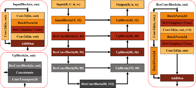
The focus of nowcasting development is transitioning from physically motivated advection methods to purely data-driven Machine Learning (ML) approaches. Nevertheless, recent work indicates that incorporating advection into the ML value chain has improved skill for radar-based precipitation nowcasts. However, the generality of this approach and the underlying causes remain unexplored. This study investigates the generality by probing the approach on satellite-based thunderstorm nowcasts for the first time. Resorting to a scale argument, we then put forth an explanation when and why skill improvements can be expected. In essence, advection guarantees that thunderstorm patterns relevant for nowcasting are contained in the receptive field at long lead times. To test our hypotheses, we train ResU-Nets solving segmentation tasks with lightning observations as ground truth. The input of the Baseline Neural Network (BNN) are short time series of multispectral satellite imagery and lightning observations, whereas the Advection-Informed Neural Network (AINN) additionally receives the Lagrangian persistence nowcast of all input channels at the desired lead time. Overall, we find only a minor skill improvement of the AINN over the BNN when considering fully averaged scores. However, assessing skill conditioned on lead time and wind speed, we demonstrate that our scale argument correctly predicts the onset of skill improvement of the AINN over the BNN after 2h lead time. We confirm that generally advection becomes gradually more important with longer lead times and higher wind speeds. Our work accentuates the importance of considering and incorporating the underlying physical scales when designing ML based forecasting models.
Increasing NWP Thunderstorm Predictability Using Ensemble Data and Machine Learning
Feb 18, 2025While numerical weather prediction (NWP) models are essential for forecasting thunderstorms hours in advance, NWP uncertainty, which increases with lead time, limits the predictability of thunderstorm occurrence. This study investigates how ensemble NWP data and machine learning (ML) can enhance the skill of thunderstorm forecasts. Using our recently introduced neural network model, SALAMA 1D, which identifies thunderstorm occurrence in operational forecasts of the convection-permitting ICON-D2-EPS model for Central Europe, we demonstrate that ensemble-averaging significantly improves forecast skill. Notably, an 11-hour ensemble forecast matches the skill level of a 5-hour deterministic forecast. To explain this improvement, we derive an analytic expression linking skill differences to correlations between ensemble members, which aligns with observed performance gains. This expression generalizes to any binary classification model that processes ensemble members individually. Additionally, we show that ML models like SALAMA 1D can identify patterns of thunderstorm occurrence which remain predictable for longer lead times compared to raw NWP output. Our findings quantitatively explain the benefits of ensemble-averaging and encourage the development of ML methods for thunderstorm forecasting and beyond.
Inferring Thunderstorm Occurrence from Vertical Profiles of Convection-Permitting Simulations: Physical Insights from a Physical Deep Learning Model
Sep 30, 2024Thunderstorms have significant social and economic impacts due to heavy precipitation, hail, lightning, and strong winds, necessitating reliable forecasts. Thunderstorm forecasts based on numerical weather prediction (NWP) often rely on single-level surrogate predictors, like convective available potential energy and precipitation rate, derived from vertical profiles of three-dimensional atmospheric variables. In this study, we develop SALAMA 1D, a deep neural network that directly infers the probability of thunderstorm occurrence from vertical profiles of ten atmospheric variables, bypassing single-level predictors. By training the model on convection-permitting NWP forecasts, we allow SALAMA 1D to flexibly identify convective patterns, with the goal of enhancing forecast accuracy. The model's architecture is physically motivated: sparse connections encourage interactions at similar height levels, while a shuffling mechanism prevents the model from learning non-physical patterns tied to the vertical grid. SALAMA 1D is trained over Central Europe with lightning observations as the ground truth. Comparative analysis against a baseline machine learning model that uses single-level predictors shows SALAMA 1D's superior skill across various metrics and lead times of up to at least 11 hours. Moreover, increasing the number of forecasts used to compile the training set improves skill, even when training set size is kept constant. Sensitivity analysis using saliency maps indicates that the model reconstructs environmental lapse rates and rediscovers patterns consistent with established theoretical understandings, such as positive buoyancy, convective inhibition, and ice particle formation near the tropopause, while ruling out thunderstorm occurrence based on the absence of mid-level graupel and cloud cover.
A machine-learning approach to thunderstorm forecasting through post-processing of simulation data
Mar 15, 2023Thunderstorms pose a major hazard to society and economy, which calls for reliable thunderstorm forecasts. In this work, we introduce SALAMA, a feedforward neural network model for identifying thunderstorm occurrence in numerical weather prediction (NWP) data. The model is trained on convection-resolving ensemble forecasts over Central Europe and lightning observations. Given only a set of pixel-wise input parameters that are extracted from NWP data and related to thunderstorm development, SALAMA infers the probability of thunderstorm occurrence in a reliably calibrated manner. For lead times up to eleven hours, we find a forecast skill superior to classification based only on convective available potential energy. Varying the spatiotemporal criteria by which we associate lightning observations with NWP data, we show that the time scale for skillful thunderstorm predictions increases linearly with the spatial scale of the forecast.