Jane Uhd Jepsen
Towards Targeted Change Detection with Heterogeneous Remote Sensing Images for Forest Mortality Mapping
Feb 28, 2022


Abstract:In this paper we develop a method for mapping forest mortality in the forest-tundra ecotone using satellite data from heterogeneous sensors. We use medium resolution imagery in order to provide the complex pattern of forest mortality in this sparsely forested area, which has been induced by an outbreak of geometrid moths. Specifically, Landsat-5 Thematic Mapper images from before the event are used, with RADARSAT-2 providing the post-event images. We obtain the difference images for both multispectral optical and synthetic aperture radar (SAR) by using a recently developed deep learning method for translating between the two domains. These differences are stacked with the original pre- and post-event images in order to let our algorithm also learn how the areas appear before and after the change event. By doing this, and focusing on learning only the changes of interest with one-class classification (OCC), we obtain good results with very little training data.
Guided Nonlocal Means Estimation of Polarimetric Covariance for Canopy State Classification
Jun 17, 2021


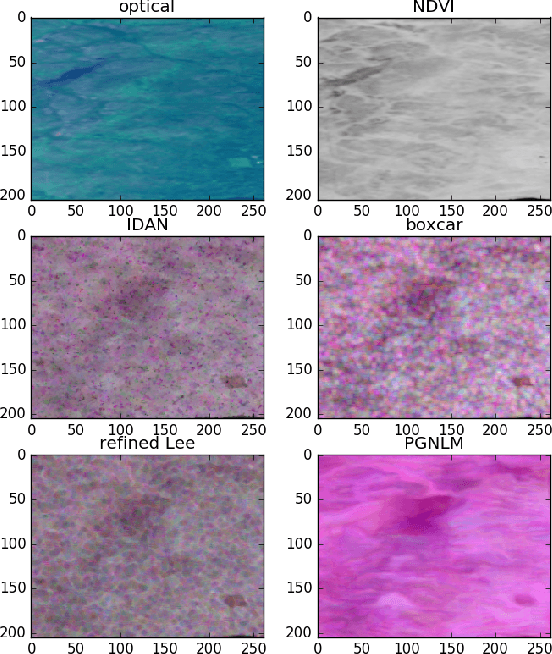
Abstract:We have developed a nonlocal algorithm for estimating polarimetric synthetic aperture radar (PolSAR) covariance matrices on single-look complex (SLC) format resolution. The algorithm is inspired by recent work with guided nonlocal means (NLM) speckle filtering, where a co-registered optical image is used to aid the filtering. Based on patch-wise dissimilarities in the SAR and optical domains we set the weights used for the nonlocal average of the outer product of the lexicographic target vectors which form the estimate. By use of this method we show that the estimated covariance matrices preserve the local structure better than previous filtering methods and improve the separation of live from defoliated and dead forest. The detail preserving nature of the algorithm also means that it can be applicable in other settings where preserving the SLC format resolution is necessary.
Polarimetric Guided Nonlocal Means Covariance Matrix Estimation for Defoliation Mapping
Jan 24, 2020

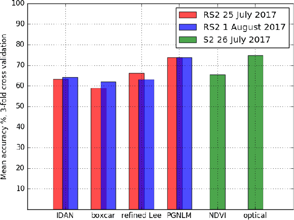
Abstract:In this study we investigate the potential for using Synthetic Aperture Radar (SAR) data to provide high resolution defoliation and regrowth mapping of trees in the tundra-forest ecotone. Using in situ measurements collected in 2017 we calculated the proportion of both live and defoliated tree crown for 165 $10 m \times 10 m$ ground plots along six transects. Quad-polarimetric SAR data from RADARSAT-2 was collected from the same area, and the complex multilook polarimetric covariance matrix was calculated using a novel extension of guided nonlocal means speckle filtering. The nonlocal approach allows us to preserve the high spatial resolution of single-look complex data, which is essential for accurate mapping of the sparsely scattered trees in the study area. Using a standard random forest classification algorithm, our filtering results in a $73.8 \%$ classification accuracy, higher than traditional speckle filtering methods, and on par with the classification accuracy based on optical data.
 Add to Chrome
 Add to Firefox
 Add to Edge