Hamed Farahmand
A Spatial-temporal Graph Deep Learning Model for Urban Flood Nowcasting Leveraging Heterogeneous Community Features
Nov 17, 2021


Abstract:The objective of this study is to develop and test a novel structured deep-learning modeling framework for urban flood nowcasting by integrating physics-based and human-sensed features. We present a new computational modeling framework including an attention-based spatial-temporal graph convolution network (ASTGCN) model and different streams of data that are collected in real-time, preprocessed, and fed into the model to consider spatial and temporal information and dependencies that improve flood nowcasting. The novelty of the computational modeling framework is threefold; first, the model is capable of considering spatial and temporal dependencies in inundation propagation thanks to the spatial and temporal graph convolutional modules; second, it enables capturing the influence of heterogeneous temporal data streams that can signal flooding status, including physics-based features such as rainfall intensity and water elevation, and human-sensed data such as flood reports and fluctuations of human activity. Third, its attention mechanism enables the model to direct its focus on the most influential features that vary dynamically. We show the application of the modeling framework in the context of Harris County, Texas, as the case study and Hurricane Harvey as the flood event. Results indicate that the model provides superior performance for the nowcasting of urban flood inundation at the census tract level, with a precision of 0.808 and a recall of 0.891, which shows the model performs better compared with some other novel models. Moreover, ASTGCN model performance improves when heterogeneous dynamic features are added into the model that solely relies on physics-based features, which demonstrates the promise of using heterogenous human-sensed data for flood nowcasting,
Predicting Road Flooding Risk with Machine Learning Approaches Using Crowdsourced Reports and Fine-grained Traffic Data
Aug 30, 2021


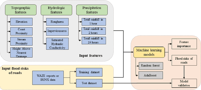
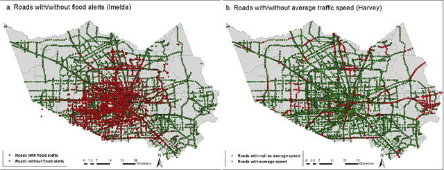
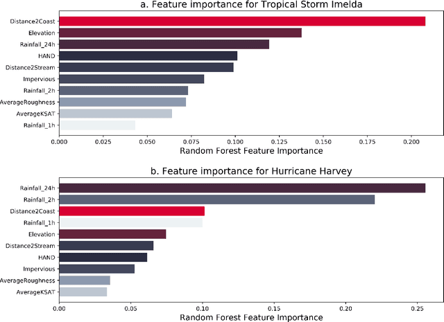
Abstract:The objective of this study is to predict road flooding risks based on topographic, hydrologic, and temporal precipitation features using machine learning models. Predictive flood monitoring of road network flooding status plays an essential role in community hazard mitigation, preparedness, and response activities. Existing studies related to the estimation of road inundations either lack observed road inundation data for model validations or focus mainly on road inundation exposure assessment based on flood maps. This study addresses this limitation by using crowdsourced and fine-grained traffic data as an indicator of road inundation, and topographic, hydrologic, and temporal precipitation features as predictor variables. Two tree-based machine learning models (random forest and AdaBoost) were then tested and trained for predicting road inundations in the contexts of 2017 Hurricane Harvey and 2019 Tropical Storm Imelda in Harris County, Texas. The findings from Hurricane Harvey indicate that precipitation is the most important feature for predicting road inundation susceptibility, and that topographic features are more essential than hydrologic features for predicting road inundations in both storm cases. The random forest and AdaBoost models had relatively high AUC scores (0.860 and 0.810 for Harvey respectively and 0.790 and 0.720 for Imelda respectively) with the random forest model performing better in both cases. The random forest model showed stable performance for Harvey, while varying significantly for Imelda. This study advances the emerging field of smart flood resilience in terms of predictive flood risk mapping at the road level. For example, such models could help impacted communities and emergency management agencies develop better preparedness and response strategies with improved situational awareness of road inundation likelihood as an extreme weather event unfolds.
A Hybrid Deep Learning Model for Predictive Flood Warning and Situation Awareness using Channel Network Sensors Data
Jun 15, 2020


Abstract:The objective of this study is to create and test a hybrid deep learning model, FastGRNN-FCN (Fast, Accurate, Stable and Tiny Gated Recurrent Neural Network-Fully Convolutional Neural Network), for urban flood prediction and situation awareness using channel network sensors data. The study used Harris County, Texas as the testbed, and obtained channel sensor data from three historical flood events (e.g., 2016 Tax Day Flood, 2016 Memorial Day flood, and 2017 Hurricane Harvey Flood) for training and validating the hybrid deep learning model. The flood data are divided into a multivariate time series and used as the model input. Each input comprises nine variables, including information of the studied channel sensor and its predecessor and successor sensors in the channel network. Precision-recall curve and F-measure are used to identify the optimal set of model parameters. The optimal model with a weight of 1 and a critical threshold of 0.63 are obtained through one hundred iterations based on examining different weights and thresholds. The test accuracy and F-measure eventually reach 97.8% and 0.8, respectively. The model is then tested in predicting the 2019 Imelda flood in Houston and the results show an excellent match with the empirical flood. The results show that the model enables accurate prediction of the spatial-temporal flood propagation and recession and provides emergency response officials with a situation awareness and predictive flood warning tool for prioritizing the flood response and resource allocation strategies.
 Add to Chrome
 Add to Firefox
 Add to Edge