Fernanda B. J. R. Dallaqua
ForestEyes Project: Conception, Enhancements, and Challenges
Aug 24, 2022


Abstract:Rainforests play an important role in the global ecosystem. However, significant regions of them are facing deforestation and degradation due to several reasons. Diverse government and private initiatives were created to monitor and alert for deforestation increases from remote sensing images, using different ways to deal with the notable amount of generated data. Citizen Science projects can also be used to reach the same goal. Citizen Science consists of scientific research involving nonprofessional volunteers for analyzing, collecting data, and using their computational resources to outcome advancements in science and to increase the public's understanding of problems in specific knowledge areas such as astronomy, chemistry, mathematics, and physics. In this sense, this work presents a Citizen Science project called ForestEyes, which uses volunteer's answers through the analysis and classification of remote sensing images to monitor deforestation regions in rainforests. To evaluate the quality of those answers, different campaigns/workflows were launched using remote sensing images from Brazilian Legal Amazon and their results were compared to an official groundtruth from the Amazon Deforestation Monitoring Project PRODES. In this work, the first two workflows that enclose the State of Rond\^onia in the years 2013 and 2016 received more than $35,000$ answers from $383$ volunteers in the $2,050$ created tasks in only two and a half weeks after their launch. For the other four workflows, even enclosing the same area (Rond\^onia) and different setups (e.g., image segmentation method, image resolution, and detection target), they received $51,035$ volunteers' answers gathered from $281$ volunteers in $3,358$ tasks. In the performed experiments...
Neuroevolution-based Classifiers for Deforestation Detection in Tropical Forests
Aug 23, 2022


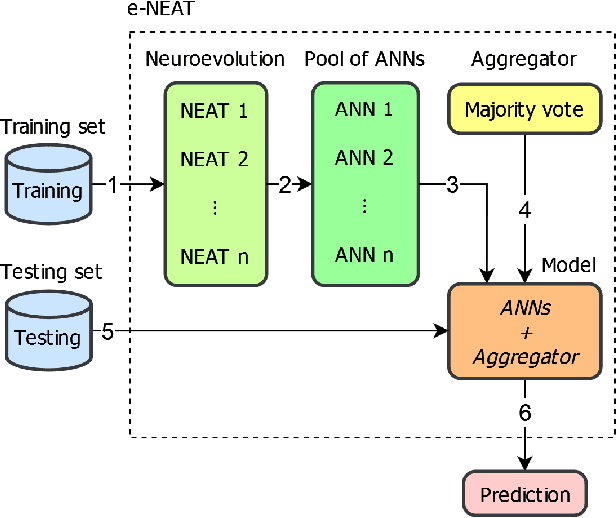
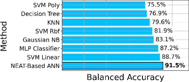
Abstract:Tropical forests represent the home of many species on the planet for flora and fauna, retaining billions of tons of carbon footprint, promoting clouds and rain formation, implying a crucial role in the global ecosystem, besides representing the home to countless indigenous peoples. Unfortunately, millions of hectares of tropical forests are lost every year due to deforestation or degradation. To mitigate that fact, monitoring and deforestation detection programs are in use, in addition to public policies for the prevention and punishment of criminals. These monitoring/detection programs generally use remote sensing images, image processing techniques, machine learning methods, and expert photointerpretation to analyze, identify and quantify possible changes in forest cover. Several projects have proposed different computational approaches, tools, and models to efficiently identify recent deforestation areas, improving deforestation monitoring programs in tropical forests. In this sense, this paper proposes the use of pattern classifiers based on neuroevolution technique (NEAT) in tropical forest deforestation detection tasks. Furthermore, a novel framework called e-NEAT has been created and achieved classification results above $90\%$ for balanced accuracy measure in the target application using an extremely reduced and limited training set for learning the classification models. These results represent a relative gain of $6.2\%$ over the best baseline ensemble method compared in this paper
 Add to Chrome
 Add to Firefox
 Add to Edge