E. Ulises Moya-Sánchez
Towards more efficient agricultural practices via transformer-based crop type classification
Nov 04, 2024


Abstract:Machine learning has great potential to increase crop production and resilience to climate change. Accurate maps of where crops are grown are a key input to a number of downstream policy and research applications. In this proposal, we present preliminary work showing that it is possible to accurately classify crops from time series derived from Sentinel 1 and 2 satellite imagery in Mexico using a pixel-based binary crop/non-crop time series transformer model. We also find preliminary evidence that meta-learning approaches supplemented with data from similar agro-ecological zones may improve model performance. Due to these promising results, we propose further development of this method with the goal of accurate multi-class crop classification in Jalisco, Mexico via meta-learning with a dataset comprising similar agro-ecological zones.
Agave crop segmentation and maturity classification with deep learning data-centric strategies using very high-resolution satellite imagery
Mar 21, 2023Abstract:The responsible and sustainable agave-tequila production chain is fundamental for the social, environment and economic development of Mexico's agave regions. It is therefore relevant to develop new tools for large scale automatic agave region monitoring. In this work, we present an Agave tequilana Weber azul crop segmentation and maturity classification using very high resolution satellite imagery, which could be useful for this task. To achieve this, we solve real-world deep learning problems in the very specific context of agave crop segmentation such as lack of data, low quality labels, highly imbalanced data, and low model performance. The proposed strategies go beyond data augmentation and data transfer combining active learning and the creation of synthetic images with human supervision. As a result, the segmentation performance evaluated with Intersection over Union (IoU) value increased from 0.72 to 0.90 in the test set. We also propose a method for classifying agave crop maturity with 95\% accuracy. With the resulting accurate models, agave production forecasting can be made available for large regions. In addition, some supply-demand problems such excessive supplies of agave or, deforestation, could be detected early.
Jalisco's multiclass land cover analysis and classification using a novel lightweight convnet with real-world multispectral and relief data
Jan 26, 2022Abstract:The understanding of global climate change, agriculture resilience, and deforestation control rely on the timely observations of the Land Use and Land Cover Change (LULCC). Recently, some deep learning (DL) methods have been adapted to make an automatic classification of Land Cover (LC) for global and homogeneous data. However, most of these DL models can not apply effectively to real-world data. i.e. a large number of classes, multi-seasonal data, diverse climate regions, high imbalance label dataset, and low-spatial resolution. In this work, we present our novel lightweight (only 89k parameters) Convolution Neural Network (ConvNet) to make LC classification and analysis to handle these problems for the Jalisco region. In contrast to the global approaches, the regional data provide the context-specificity that is required for policymakers to plan the land use and management, conservation areas, or ecosystem services. In this work, we combine three real-world open data sources to obtain 13 channels. Our embedded analysis anticipates the limited performance in some classes and gives us the opportunity to group the most similar, as a result, the test accuracy performance increase from 73 % to 83 %. We hope that this research helps other regional groups with limited data sources or computational resources to attain the United Nations Sustainable Development Goal (SDG) concerning Life on Land.
A trainable monogenic ConvNet layer robust in front of large contrast changes in image classification
Sep 14, 2021


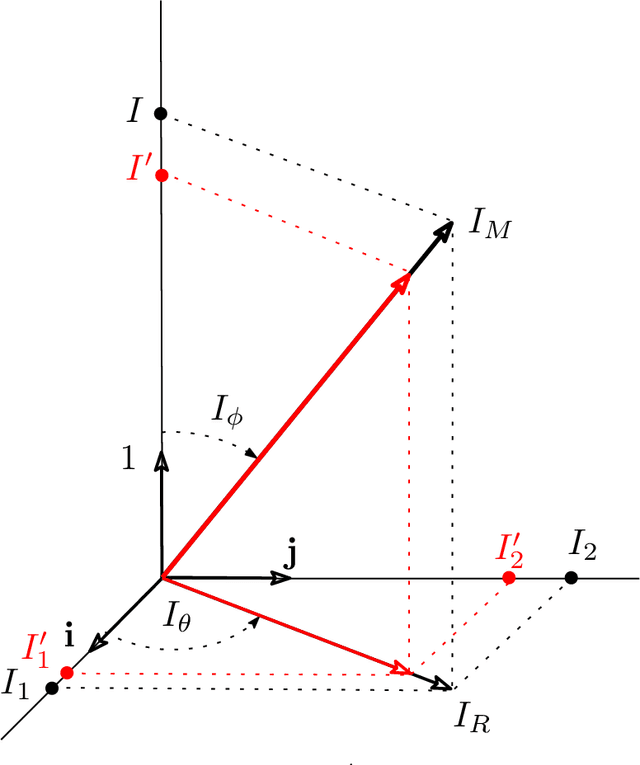
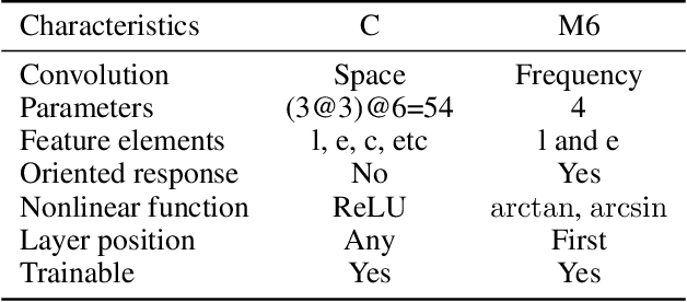
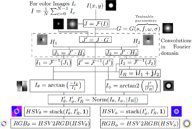
Abstract:Convolutional Neural Networks (ConvNets) at present achieve remarkable performance in image classification tasks. However, current ConvNets cannot guarantee the capabilities of the mammalian visual systems such as invariance to contrast and illumination changes. Some ideas to overcome the illumination and contrast variations usually have to be tuned manually and tend to fail when tested with other types of data degradation. In this context, we present a new bio-inspired {entry} layer, M6, which detects low-level geometric features (lines, edges, and orientations) which are similar to patterns detected by the V1 visual cortex. This new trainable layer is capable of coping with image classification even with large contrast variations. The explanation for this behavior is the monogenic signal geometry, which represents each pixel value in a 3D space using quaternions, a fact that confers a degree of explainability to the networks. We compare M6 with a conventional convolutional layer (C) and a deterministic quaternion local phase layer (Q9). The experimental setup {is designed to evaluate the robustness} of our M6 enriched ConvNet model and includes three architectures, four datasets, three types of contrast degradation (including non-uniform haze degradations). The numerical results reveal that the models with M6 are the most robust in front of any kind of contrast variations. This amounts to a significant enhancement of the C models, which usually have reasonably good performance only when the same training and test degradation are used, except for the case of maximum degradation. Moreover, the Structural Similarity Index Measure (SSIM) is used to analyze and explain the robustness effect of the M6 feature maps under any kind of contrast degradations.
 Add to Chrome
 Add to Firefox
 Add to Edge