Binh Nguyen Thanh
Deep4Air: A Novel Deep Learning Framework for Airport Airside Surveillance
Oct 02, 2020


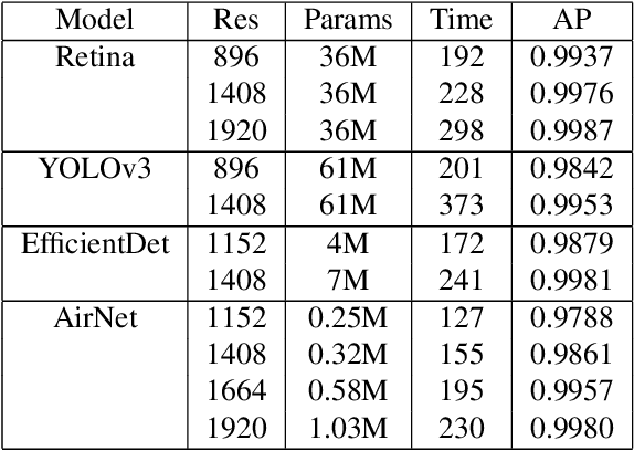
Abstract:An airport runway and taxiway (airside) area is a highly dynamic and complex environment featuring interactions between different types of vehicles (speed and dimension), under varying visibility and traffic conditions. Airport ground movements are deemed safety-critical activities, and safe-separation procedures must be maintained by Air Traffic Controllers (ATCs). Large airports with complicated runway-taxiway systems use advanced ground surveillance systems. However, these systems have inherent limitations and a lack of real-time analytics. In this paper, we propose a novel computer-vision based framework, namely "Deep4Air", which can not only augment the ground surveillance systems via the automated visual monitoring of runways and taxiways for aircraft location, but also provide real-time speed and distance analytics for aircraft on runways and taxiways. The proposed framework includes an adaptive deep neural network for efficiently detecting and tracking aircraft. The experimental results show an average precision of detection and tracking of up to 99.8% on simulated data with validations on surveillance videos from the digital tower at George Bush Intercontinental Airport. The results also demonstrate that "Deep4Air" can locate aircraft positions relative to the airport runway and taxiway infrastructure with high accuracy. Furthermore, aircraft speed and separation distance are monitored in real-time, providing enhanced safety management.
 Add to Chrome
 Add to Firefox
 Add to Edge