A Benoit
LISTIC
Deep learning based automatic detection of offshore oil slicks using SAR data and contextual information
Apr 13, 2022Abstract:Ocean surface monitoring, especially oil slick detection, has become mandatory due to its importance for oil exploration and risk prevention on ecosystems. For years, the detection task has been performed manually by photo-interpreters using Synthetic Aperture Radar (SAR) images with the help of contextual data such as wind. This tedious manual work cannot handle the increasing amount of data collected by the available sensors and thus requires automation. Literature reports conventional and semi-automated detection methods that generally focus either on oil slicks originating from anthropogenic (spills) or natural (seeps) sources on limited data collections. As an extension, this paper presents the automation of offshore oil slicks on an extensive database with both kinds of slicks. It builds upon the slick annotations of specialized photo-interpreters on Sentinel-1 SAR data for 4 years over 3 exploration and monitoring areas worldwide. All the considered SAR images and related annotation relate to real oil slick monitoring scenarios. Further, wind estimation is systematically computed to enrich the data collection. Paper contributions are the following : (i) a performance comparison of two deep learning approaches: semantic segmentation using FC-DenseNet and instance segmentation using Mask-RCNN. (ii) the introduction of meteorological information (wind speed) is deemed valuable for oil slick detection in the performance evaluation. The main results of this study show the effectiveness of slick detection by deep learning approaches, in particular FC-DenseNet, which captures more than 92% of oil instances in our test set. Furthermore, a strong correlation between model performances and contextual information such as slick size and wind speed is demonstrated in the performance evaluation. This work opens perspectives to design models that can fuse SAR and wind information to reduce the false alarm rate.
Deep learning for dehazing: Comparison and analysis
Jun 28, 2018


Abstract:We compare a recent dehazing method based on deep learning, Dehazenet, with traditional state-of-the-art approaches , on benchmark data with reference. Dehazenet estimates the depth map from transmission factor on a single color image, which is used to inverse the Koschmieder model of imaging in the presence of haze. In this sense, the solution is still attached to the Koschmieder model. We demonstrate that the transmission is very well estimated by the network, but also that this method exhibits the same limitation than others due to the use of the same imaging model.
Three dimensional Deep Learning approach for remote sensing image classification
Jun 15, 2018


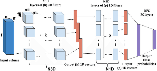
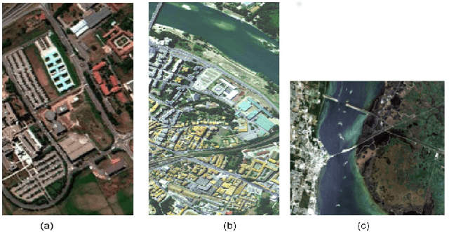
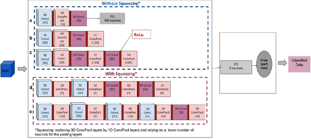
Abstract:Recently, a variety of approaches has been enriching the field of Remote Sensing (RS) image processing and analysis. Unfortunately, existing methods remain limited faced to the rich spatio-spectral content of today's large datasets. It would seem intriguing to resort to Deep Learning (DL) based approaches at this stage with regards to their ability to offer accurate semantic interpretation of the data. However, the specificity introduced by the coexistence of spectral and spatial content in the RS datasets widens the scope of the challenges presented to adapt DL methods to these contexts. Therefore, the aim of this paper is firstly to explore the performance of DL architectures for the RS hyperspectral dataset classification and secondly to introduce a new three-dimensional DL approach that enables a joint spectral and spatial information process. A set of three-dimensional schemes is proposed and evaluated. Experimental results based on well knownhyperspectral datasets demonstrate that the proposed method is able to achieve a better classification rate than state of the art methods with lower computational costs.
 Add to Chrome
 Add to Firefox
 Add to Edge